- Discover
-
Expertise
-
Alternative Delivery
- I-275 at I-4 Downtown Tampa Interchange Design-Build
- Wekiva Parkway Section 8 Interchange
- US 17/92 Interchange at SR 436
- SR 9B Extension from I-95 to US 1
- A. Max Brewer Bridge Replacement
- I-95 Widening from the Indian River/Brevard County Line to Malabar Road
- SR 528 (Beachline Expressway) at Innovation Way Interchange
- SR 570 Polk Parkway Widening from I-4 to Pace Road
- I-95 Express Lanes and Ramp Signals – Phase 3A-1
- Pollard Road Extension over Peace Creek
- I-485 Widening from I-77 to Rea Road
- Monroe Bypass/Connector Design-Build
- Construction Services
- Ecological Services
-
Federal Services
- Range of the Future Study
- US Coast Guard Air Station (Clearwater)
- Ascension Island Fire Station Renovation
- Patrick Space Force Base Water Lines Repair
- Patrick Space Force Base Living Shoreline Restoration
- P-505 Electrical Hardening and Black Start CHP at Marine Corps Air Station Beaufort
- Naval Station at Guantanamo Bay Survey Services
- Repair Phillips Parkway and Speed Limit Study
- Ascension Island Auxiliary Airfield Surveying and Mapping Services
-
Geographic Information Systems (GIS)
- Thermal Design/Comprehensive Campus LiDAR Collection
- Greater Orlando Aviation Authority (GOAA) Strategic Commerical Land Development Program
- University of Florida Sanitary Sewer GIS Mapping
- Ascension Island Auxiliary Airfield GIS Integration
- Santa Rosa County School District's School Transportation & Capacity GIS Analysis
- Gainesville Community Redevelopment Agency Socioeconomic Analysis and Site Suitability Report
- Real Estate Site Suitability and Development Analysis
- SR 836 (Dolphin Expressway) GIS Asset Inventory of Pre-Post Construction
- Alachua County Public Schools GIS and School Planning Professional Services
- Patrick Air Force Base Living Shoreline Restoration GIS Analysis
- Florida Army National Guard Readiness Center GIS Inventory & Integration
- Comprehensive Transit Study Puerto Rico GIS Analysis
- Land Development
- Structural Engineering
-
Subsurface Utility Engineering (SUE)
- Thermal Design/Comprehensive Campus LiDAR Collection
- P-505 Electrical Hardening and Black Start CHP at Marine Corps Air Station Beaufort
- Resurface & Safety Improvements Turnpike Mainline
- University of Florida Rabon Utility Mapping
- FP&L Subsurface Utility Engineering Continuing On-Call Contract
- Lockheed Martin Subsurface Utility Engineering Services
- Palm Coast Parkway Subsurface Utility Engineering Services
- Surveying & Mapping/Geospatial
-
Traffic Impact Analysis
- 505 West Chapel Hill Street
- 5th Street Station
- Beale Farm Industrial Park
- Blue Mountain Mist Resort
- The Villages at McCullers Walk
- Fredericksburg National Baseball Stadium
- Hendrick Southpoint Auto Mall
- Apex Friendship Elementary School
- Whole Foods Center
- Barclay West
- Grove 98
- Pullen Drive Extension/Catholic Diocese
- Trails/Parks & Recreation Facilities
- Transportation
-
Utilities Engineering
- Ascension Island Fire Station Renovation
- M-1 Canal Water Main Extension
- 5th Street Bridge Utility Replacement
- Captain’s Cove Wastewater Plant Revisions & Permit Renewal
- City of Fort Myers Downtown Utility & Streetscape Improvement
- Florida Caverns State Park Lift Station Rehab
- Tween Waters Inn Wastewater Plant Permit Renewal
- City of Fort Myers Wastewater Capacity Studies
- Patrick Air Force Base Water Lines Repair
- Big Lagoon Boat Ramp Wastewater System
- St. Joseph State Park Septic Tank Replacement
- WildBlue Development Wastewater Modeling
- A-1 Gator Wastewater Capacity Increase
- Visualization Services
- Water Resources/Stormwater Management
-
Alternative Delivery
- Careers
- News
- #DRMPerspective
- Team With Us
- Locations
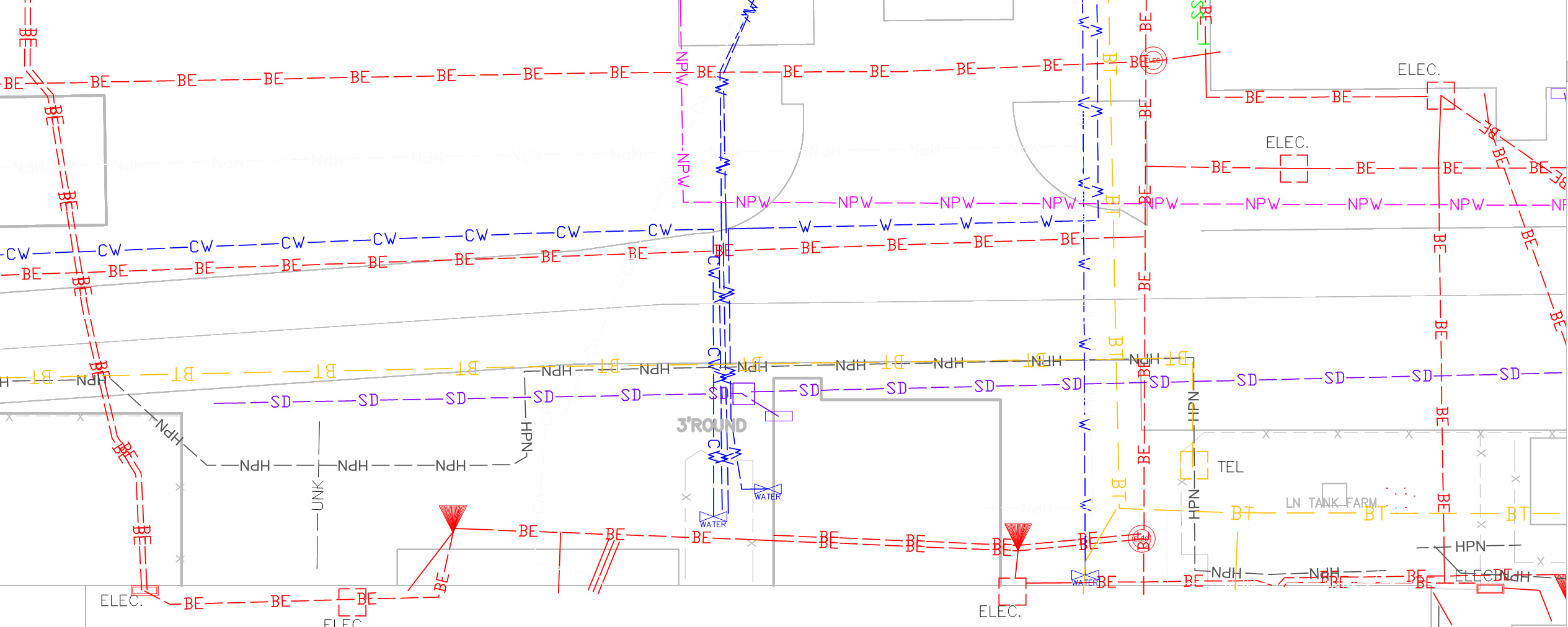
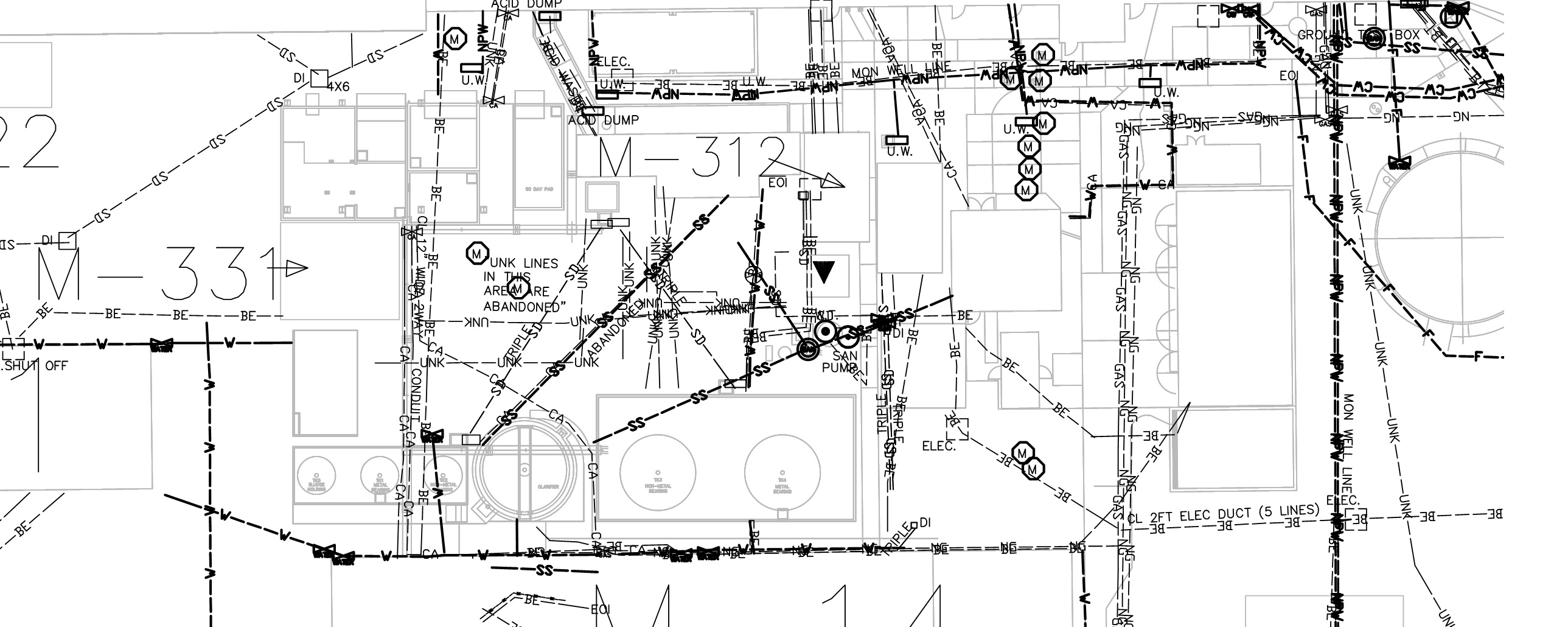
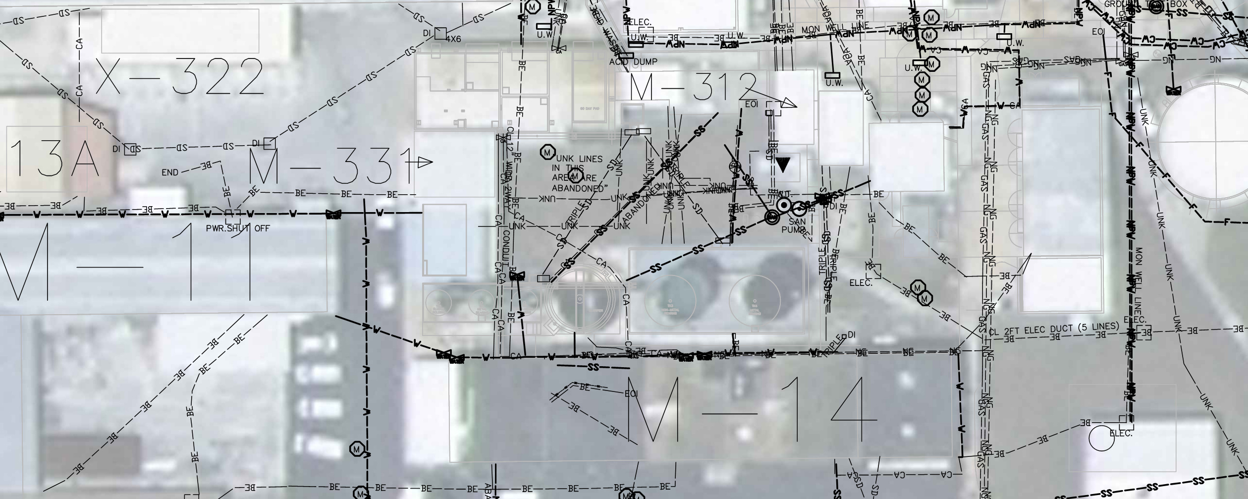
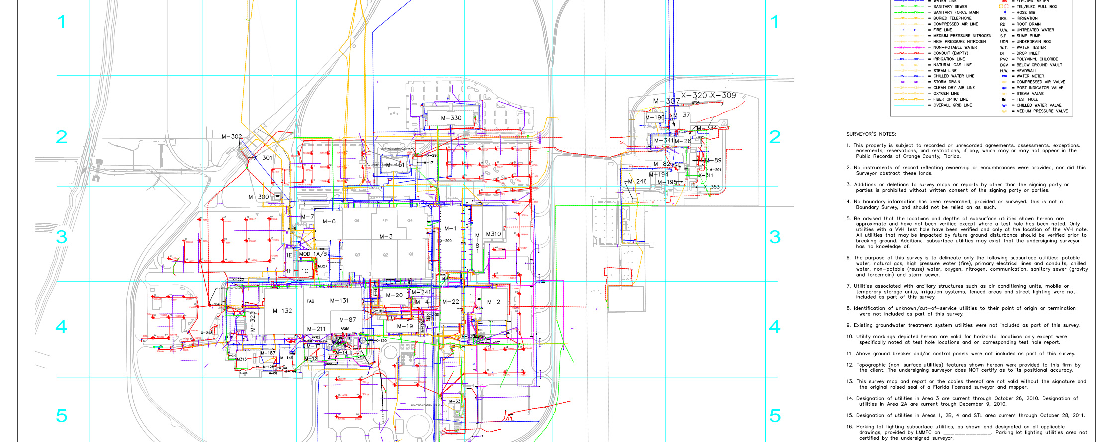
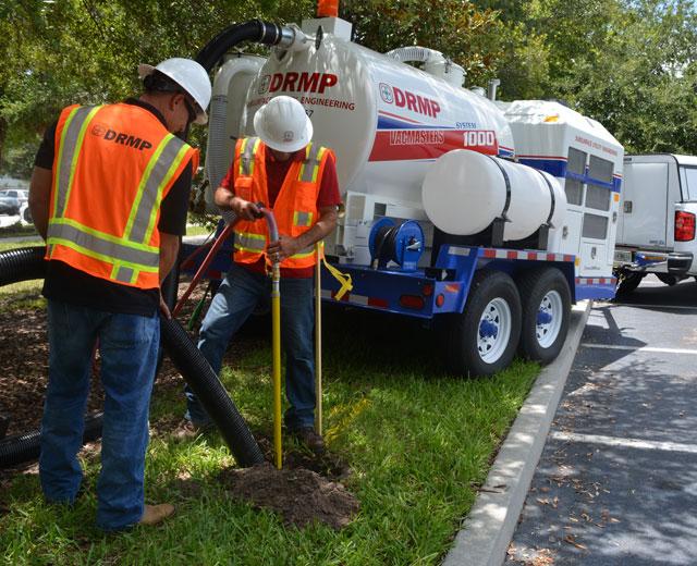
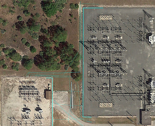
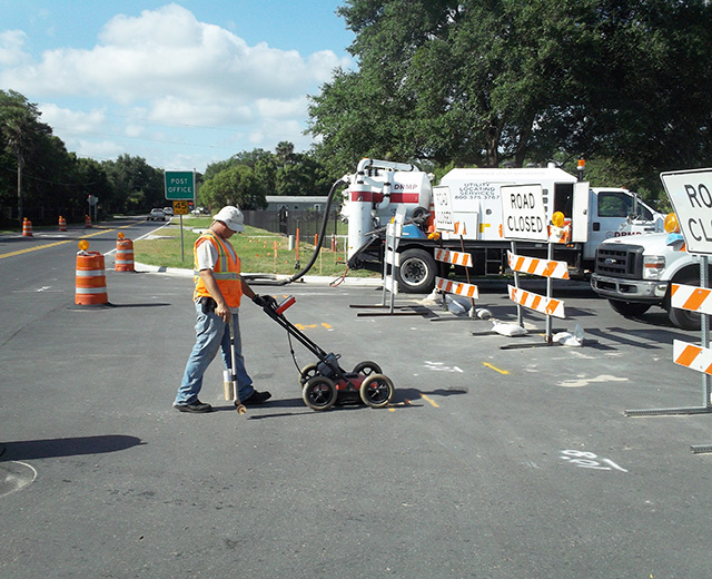
Lockheed Martin Subsurface Utility Engineering Services
Lockheed Martin requested their engineering consultant to update their utility records within the limits of their Sand Lake Road Missile and Fire Control facility. The existing utility records they had been using were outdated and often inaccurate due to 50 years of reconstruction and updating underground facilities on the plant property.
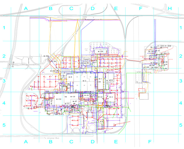
DRMP provided updated underground utility information by starting with Quality Level “D” Utility Research which established all utility owners and secured as-builts and other utility information to begin designation. A Quality Level “C” Site Visit Investigation was then conducted of the areas defined within the project limits and on site investigation was performed to establish utility connection points to assist during designation and to identify any safety hazards that might be encountered during the designation phase. Quality Level “B” Designation of the project was coordinated with the engineering consultant and Lockheed Martin personnel to mark the most critical areas first by using Electromagnetic (EM), Ground Penetrating Radar (GPR) and the Utility As-builts, collected during the research phase. Once each area was completed, a field sketch of utilities was created by the designation teams and given to survey technicians for the mapping effort. Survey information was collected and added to the topographic view of the areas marked and plans where checked for accuracy and sent back to the engineering consultant for their quality edits. This process produced the most accurate utility prints of the project available for main plant operations and new construction within the plant. Once the critical areas were established from the Designation phase, a Test Hole Plan was produced. Quality Level “A” Location was performed of the test holes with vacuum excavation to establish the exact horizontal and vertical position at each critical location. A survey was then performed of the test hole, data collected and adjusted utility mapping using the survey and test hole data forms to complete mapping effort to develop the most accurate inventory of underground utilities created to date.
DRMP produced a set of utility maps for the plant identifying existing utility lines, both active and abandoned, and provided this information in a CAD format. This allowed Lockheed Martin to have an accurate assessment of existing underground utilities in the main plant area for future construction and troubleshooting infrastructure problems. By providing the information in a CAD format, Lockheed Martin has an added advantage to continue to update their information as they reconstruct areas. The format also provides the ability to export to another database format, such as a ArcGIS.
Key Facts
Location:
Florida
Client:
Lockheed Martin
Size:
2080 Acres
Highlights:
- Utility designation
- Utility location
- Utility mapping
- Utility survey
- Quality Level A locates
- Quality Level B locates
- Quality Level C locates
- Quality Level D locates