- Discover
-
Expertise
-
Alternative Delivery
- I-275 at I-4 Downtown Tampa Interchange Design-Build
- Wekiva Parkway Section 8 Interchange
- US 17/92 Interchange at SR 436
- SR 9B Extension from I-95 to US 1
- A. Max Brewer Bridge Replacement
- I-95 Widening from the Indian River/Brevard County Line to Malabar Road
- SR 528 (Beachline Expressway) at Innovation Way Interchange
- SR 570 Polk Parkway Widening from I-4 to Pace Road
- I-95 Express Lanes and Ramp Signals – Phase 3A-1
- Pollard Road Extension over Peace Creek
- I-485 Widening from I-77 to Rea Road
- Monroe Bypass/Connector Design-Build
- Construction Services
- Ecological Services
-
Federal Services
- Range of the Future Study
- US Coast Guard Air Station (Clearwater)
- Ascension Island Fire Station Renovation
- Patrick Space Force Base Water Lines Repair
- Patrick Space Force Base Living Shoreline Restoration
- P-505 Electrical Hardening and Black Start CHP at Marine Corps Air Station Beaufort
- Naval Station at Guantanamo Bay Survey Services
- Repair Phillips Parkway and Speed Limit Study
- Ascension Island Auxiliary Airfield Surveying and Mapping Services
-
Geographic Information Systems (GIS)
- Thermal Design/Comprehensive Campus LiDAR Collection
- Greater Orlando Aviation Authority (GOAA) Strategic Commerical Land Development Program
- University of Florida Sanitary Sewer GIS Mapping
- Ascension Island Auxiliary Airfield GIS Integration
- Santa Rosa County School District's School Transportation & Capacity GIS Analysis
- Gainesville Community Redevelopment Agency Socioeconomic Analysis and Site Suitability Report
- Real Estate Site Suitability and Development Analysis
- SR 836 (Dolphin Expressway) GIS Asset Inventory of Pre-Post Construction
- Alachua County Public Schools GIS and School Planning Professional Services
- Patrick Air Force Base Living Shoreline Restoration GIS Analysis
- Florida Army National Guard Readiness Center GIS Inventory & Integration
- Comprehensive Transit Study Puerto Rico GIS Analysis
- Land Development
- Structural Engineering
-
Subsurface Utility Engineering (SUE)
- Thermal Design/Comprehensive Campus LiDAR Collection
- P-505 Electrical Hardening and Black Start CHP at Marine Corps Air Station Beaufort
- Resurface & Safety Improvements Turnpike Mainline
- University of Florida Rabon Utility Mapping
- FP&L Subsurface Utility Engineering Continuing On-Call Contract
- Lockheed Martin Subsurface Utility Engineering Services
- Palm Coast Parkway Subsurface Utility Engineering Services
- Surveying & Mapping/Geospatial
-
Traffic Impact Analysis
- 505 West Chapel Hill Street
- 5th Street Station
- Beale Farm Industrial Park
- Blue Mountain Mist Resort
- The Villages at McCullers Walk
- Fredericksburg National Baseball Stadium
- Hendrick Southpoint Auto Mall
- Apex Friendship Elementary School
- Whole Foods Center
- Barclay West
- Grove 98
- Pullen Drive Extension/Catholic Diocese
- Trails/Parks & Recreation Facilities
- Transportation
-
Utilities Engineering
- Ascension Island Fire Station Renovation
- M-1 Canal Water Main Extension
- 5th Street Bridge Utility Replacement
- Captain’s Cove Wastewater Plant Revisions & Permit Renewal
- City of Fort Myers Downtown Utility & Streetscape Improvement
- Florida Caverns State Park Lift Station Rehab
- Tween Waters Inn Wastewater Plant Permit Renewal
- City of Fort Myers Wastewater Capacity Studies
- Patrick Air Force Base Water Lines Repair
- Big Lagoon Boat Ramp Wastewater System
- St. Joseph State Park Septic Tank Replacement
- WildBlue Development Wastewater Modeling
- A-1 Gator Wastewater Capacity Increase
- Visualization Services
- Water Resources/Stormwater Management
-
Alternative Delivery
- Careers
- News
- #DRMPerspective
- Team With Us
- Locations

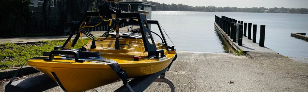
DRMP’s Investment in the Z-Boat Takes Hydrographic Surveying to a New Level
March 21st, 2023


DRMP has invested in a new piece of equipment, the Teledyne Z-Boat 1800T (Trimble Edition), for its survey fleet that will potentially provide cost savings for clients, additional service offerings, and increased safety for the firm’s staff.
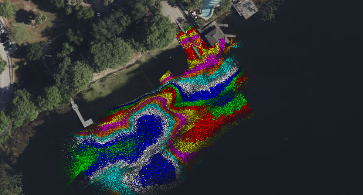
The Z-Boat is a high performance portable remotely operated survey boat that collects hydrographic survey data. Hydrographic surveys measure the depth and bottom configuration of bodies of water.
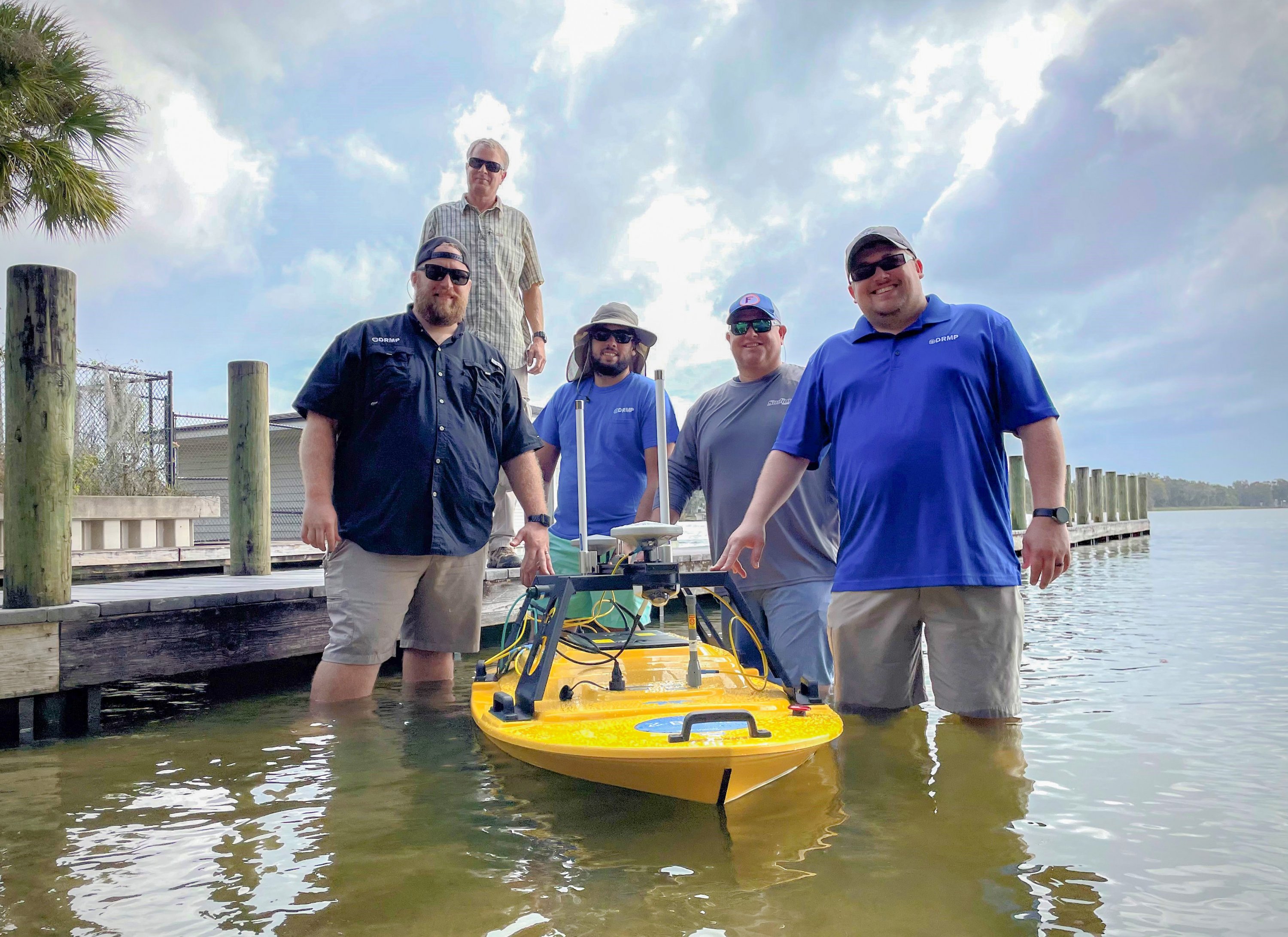
Prior to investing in the boat, our surveyors either had to subcontract the work out for clients; conduct hydrographic surveys by hand using conventional methods, such as a single surveyor wading in water with a survey rod; or using manned craft while hanging equipment over the edge to take measurements.
Along with a safer method of performing surveys, the Z-Boat opens the door to more opportunities for our clients. Our goal in the future is to provide more bridge surveys and seagrass mapping for our Survey and Mapping market sector.
Client Benefits
The Z-Boat is a more efficient way of collecting data and allows us a fast deployment option that is ideal for nearshore, canals, ponds, lakes, and other shallow water environments.
Instead of having crews manually paddle a boat around and take survey shots by hand, we can collect the data in a few minutes versus a few hours, which can provide a cost savings for clients. We use the data to create surveys or update existing ones.
DRMP’s initial interest in unmanned survey vehicles (USV) for hydrographic surveys started during a pursuit for a water management district’s survey and mapping contract. The idea was to invest in technology to continue our strides in mobile data collection and give ourselves more opportunities to provide different types of services to our clients. We ended up winning first place on that contract and plan on pursuing similar contracts in the future.
Added Safety
The Z-Boat’s innovative technology allows surveyors to perform work on the water using a safe, efficient, and cost-effective approach. In Florida, our surveyors must be watchful of encounters with alligators and venomous snakes while wading in waters. Our crews would have to take time to safely clear the area and keep a lookout the entire time they are in the water. The Z-Boat provides a safe alternative.
For one particular job, we had to survey a lake that was closed to human activity due to bacteria. However, we had no issues accessing the lake with the Z-Boat.
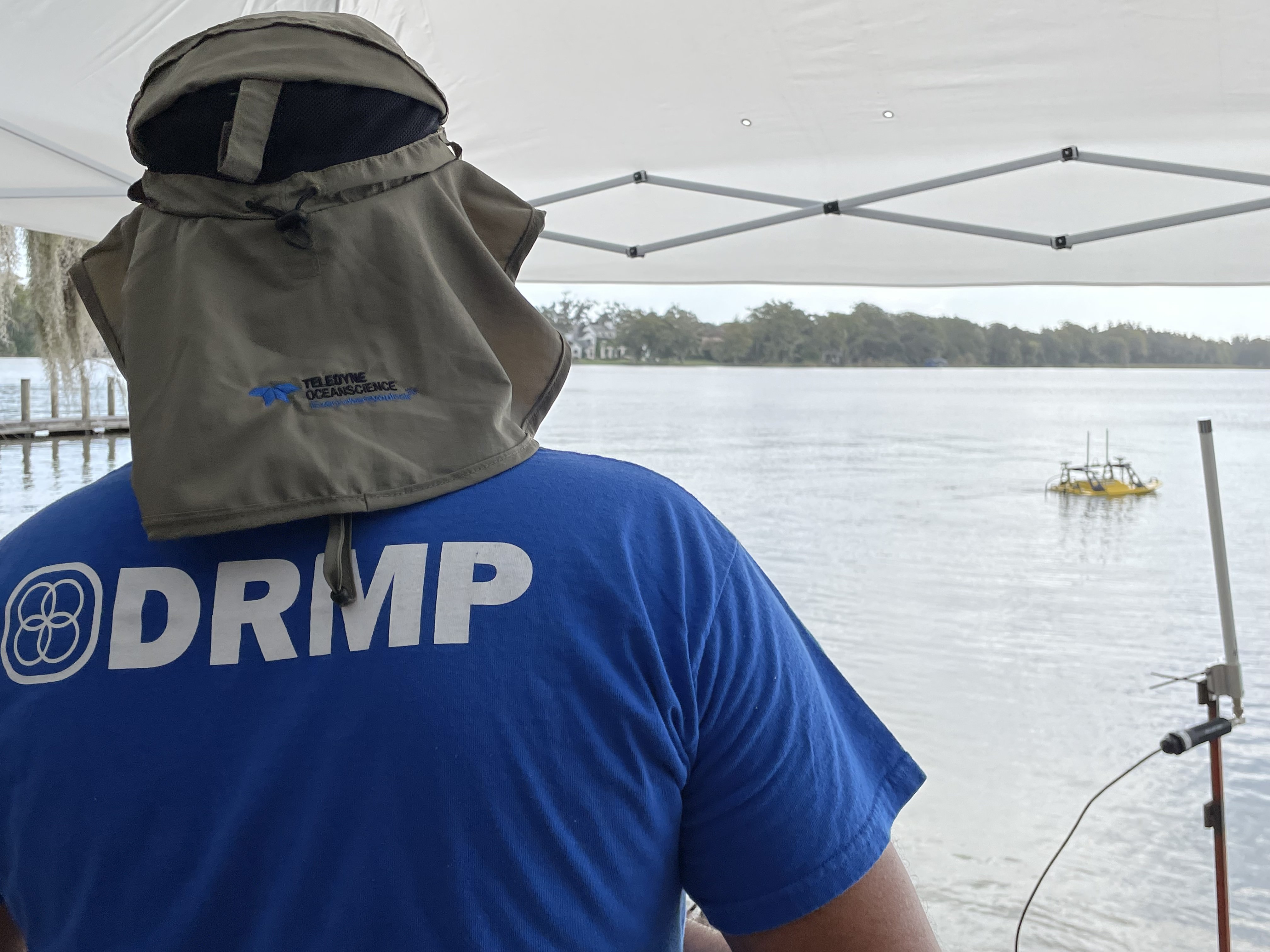
The boat is equipped with an Odom Hydrographic MB2 Multibeam Echosounder, integrated IMU, dual GNSS receivers, autonomous waypoint navigation, and an HD camera, allowing the operators to have full control and remotely view the data being collected in real-time.
Using the Multibeam sensor, we are getting survey grade data for the entire water body, instead of just survey data points at given intervals. This allows the final survey product to be more accurate and gives the client a better overall picture of what is going on under water.
So far, we have used the boat for quality assurance and quality control (QA/QC) of existing survey data on ponds, to collect the survey data for a boat ramp at a lake, and to provide survey as-builts for a pond.
Mission Not Impossible
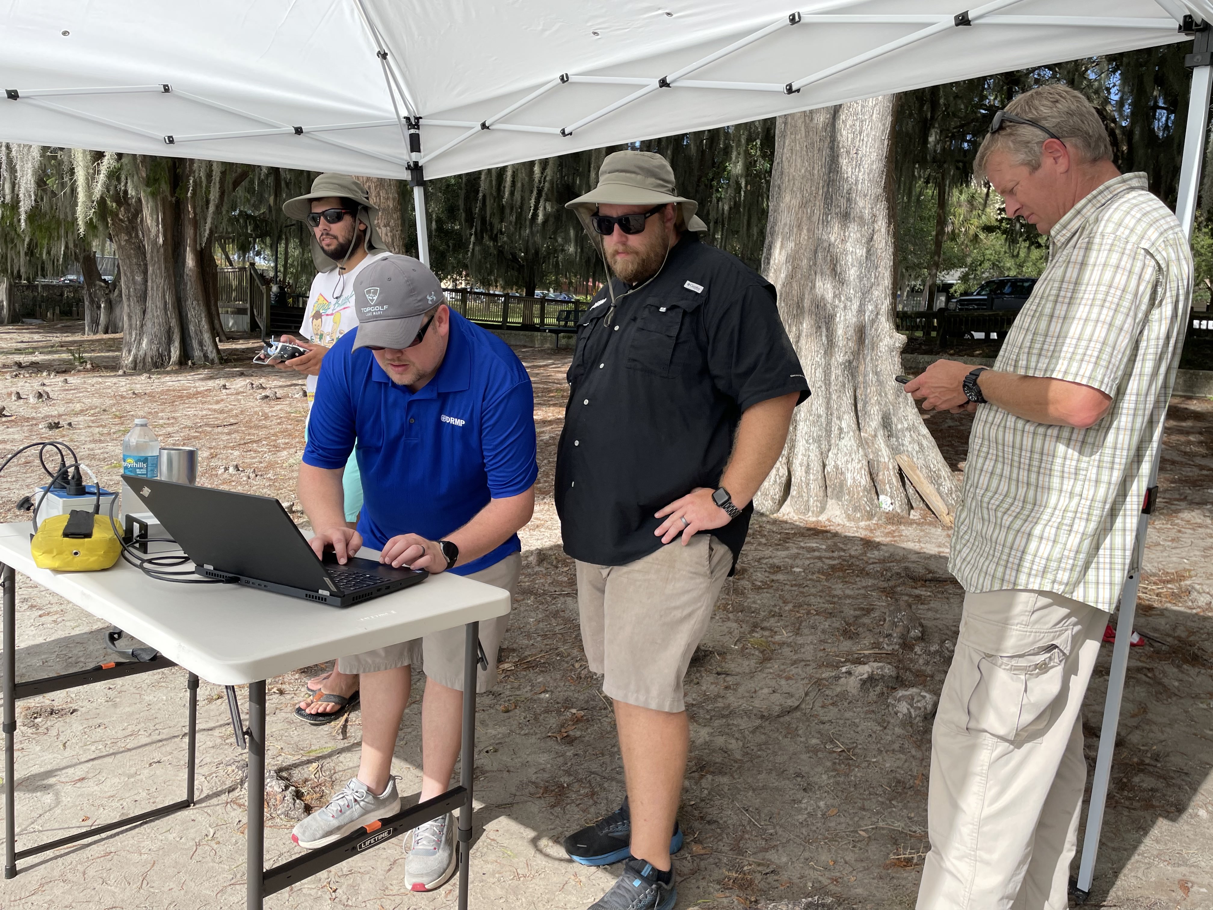
While the mission planning for the autonomous driving unit can be difficult – sometimes based on the site conditions— the manual driving of the boat is easy to maneuver. If the site is open and clear, you can plan a mission for the boat to collect data, and it will drive itself until the mission is complete. This is similar to how our UAS LiDAR system works.
Overall, this boat is quite user friendly and can be loaded and unloaded into the water with just two people. The battery life on the boat can last up to six hours, and the remote control can reach up to 2 kilometers.
DRMP’s Geospatial Services Group (Mobile LiDAR and UAS LiDAR) has been the main team to be trained on this equipment. Our goal is to cross-train other staff to use this technology. Ultimately, my team will be responsible for the boat’s maintenance, software, and data processing.
As technology continues to advance, DRMP is committed to investing in pioneering equipment that allows employees to do their jobs more safely and efficiently while providing clients with top-notch service and minimizing costs.
.jpg?v=1679079712255)
Brent Bass, PE, SIT, is a DRMP Advanced Survey Technology Department Manager
Posted in the categories All, Surveying & Mapping.

Categories
- All
- Featured Posts
- Alternative Delivery
- Construction Services
- Ecological Services
- Geographic Information Systems
- Land Development
- Structural Engineering
- Subsurface Utility Engineering
- Surveying & Mapping
- Transportation
- Water Resources/Stormwater Management
- Federal Services
- Project Development & Environment
- NEPA
- Transportation Planning/Project Development
- Utilities Engineering
Contributors
- Michael K. Albano, PE
- Bruno J. Arriola, PE, ENV SP
- Martha Ayers
- Brent Bass, PE, PSM
- Cody Bayer, PE
- Donald W. Brown, PE
- Kyle Brown, PE
- Michael Bywaletz, PE, CPESC, ENV SP
- Zach J. Carnahan, PE
- Brian Crowl, PE
- Patrick Day, PE
- Nick DeVito, PE
- Matt Floyd, PSM
- Deshon M. Fox, PE
- Scott Garth, PE, LEED AP ND
- Ryan M. Grab, CST II
- Robyn Hartz
- TJ Lallathin, Jr., PE, DBIA
- Kelly Marton, GISP
- Meaghan McCarthy
- George McLatchey, PWS, CEP
- Shawn McLemore, PE
- Jeff Miller
- Ryan Mitchell, PE
- Lisa Moon, PE
- Megan E. Mott, PE
- Josh Norman
- Julian Poole, PE
- Mark Prochak, PE
- Abby Rains
- Leo Rodriguez, PE
- Kimberly Santiago-Ortiz, PE
- Rachel L. Schmidt, PWS
- Logan Shappell
- Brian V. Smith
- Rynal Stephenson, PE
- Deston Taylor, EI
- August Thick, PLS
- Ron Wallace, PE
- Steven L. Wallace, PE
- Orville Williams
- Amanda E. Woods, PE


