- Discover
-
Expertise
-
Alternative Delivery
- I-275 at I-4 Downtown Tampa Interchange Design-Build
- Wekiva Parkway Section 8 Interchange
- US 17/92 Interchange at SR 436
- SR 9B Extension from I-95 to US 1
- A. Max Brewer Bridge Replacement
- I-95 Widening from the Indian River/Brevard County Line to Malabar Road
- SR 528 (Beachline Expressway) at Innovation Way Interchange
- SR 570 Polk Parkway Widening from I-4 to Pace Road
- I-95 Express Lanes and Ramp Signals – Phase 3A-1
- Pollard Road Extension over Peace Creek
- I-485 Widening from I-77 to Rea Road
- Monroe Bypass/Connector Design-Build
- Construction Services
- Ecological Services
-
Federal Services
- Range of the Future Study
- US Coast Guard Air Station (Clearwater)
- Ascension Island Fire Station Renovation
- Patrick Space Force Base Water Lines Repair
- Patrick Space Force Base Living Shoreline Restoration
- P-505 Electrical Hardening and Black Start CHP at Marine Corps Air Station Beaufort
- Naval Station at Guantanamo Bay Survey Services
- Repair Phillips Parkway and Speed Limit Study
- Ascension Island Auxiliary Airfield Surveying and Mapping Services
-
Geographic Information Systems (GIS)
- Thermal Design/Comprehensive Campus LiDAR Collection
- Greater Orlando Aviation Authority (GOAA) Strategic Commerical Land Development Program
- University of Florida Sanitary Sewer GIS Mapping
- Ascension Island Auxiliary Airfield GIS Integration
- Santa Rosa County School District's School Transportation & Capacity GIS Analysis
- Gainesville Community Redevelopment Agency Socioeconomic Analysis and Site Suitability Report
- Real Estate Site Suitability and Development Analysis
- SR 836 (Dolphin Expressway) GIS Asset Inventory of Pre-Post Construction
- Alachua County Public Schools GIS and School Planning Professional Services
- Patrick Air Force Base Living Shoreline Restoration GIS Analysis
- Florida Army National Guard Readiness Center GIS Inventory & Integration
- Comprehensive Transit Study Puerto Rico GIS Analysis
- Land Development
- Structural Engineering
-
Subsurface Utility Engineering (SUE)
- Thermal Design/Comprehensive Campus LiDAR Collection
- P-505 Electrical Hardening and Black Start CHP at Marine Corps Air Station Beaufort
- Resurface & Safety Improvements Turnpike Mainline
- University of Florida Rabon Utility Mapping
- FP&L Subsurface Utility Engineering Continuing On-Call Contract
- Lockheed Martin Subsurface Utility Engineering Services
- Palm Coast Parkway Subsurface Utility Engineering Services
- Surveying & Mapping/Geospatial
-
Traffic Impact Analysis
- 505 West Chapel Hill Street
- 5th Street Station
- Beale Farm Industrial Park
- Blue Mountain Mist Resort
- The Villages at McCullers Walk
- Fredericksburg National Baseball Stadium
- Hendrick Southpoint Auto Mall
- Apex Friendship Elementary School
- Whole Foods Center
- Barclay West
- Grove 98
- Pullen Drive Extension/Catholic Diocese
- Trails/Parks & Recreation Facilities
- Transportation
-
Utilities Engineering
- Ascension Island Fire Station Renovation
- M-1 Canal Water Main Extension
- 5th Street Bridge Utility Replacement
- Captain’s Cove Wastewater Plant Revisions & Permit Renewal
- City of Fort Myers Downtown Utility & Streetscape Improvement
- Florida Caverns State Park Lift Station Rehab
- Tween Waters Inn Wastewater Plant Permit Renewal
- City of Fort Myers Wastewater Capacity Studies
- Patrick Air Force Base Water Lines Repair
- Big Lagoon Boat Ramp Wastewater System
- St. Joseph State Park Septic Tank Replacement
- WildBlue Development Wastewater Modeling
- A-1 Gator Wastewater Capacity Increase
- Visualization Services
- Water Resources/Stormwater Management
-
Alternative Delivery
- Careers
- News
- #DRMPerspective
- Team With Us
- Locations

Expertise Highlight: DRMP SUE Team Overcomes Project Challenges with Persistence and Precision
November 30th, 2023


Navigating the intricacies of mapping underground utility lines on the surface for engineering projects can pose significant challenges. Such was the case when DRMP’s Jacksonville Team of Subsurface Utility Engineering (SUE) experts were subcontracted to support the extension of the Jacksonville Electric Authority’s (JEA) downtown chilled water facilities.
We were a subconsultant on this project to Four Waters Engineering, a female-owned Disadvantaged Business Enterprise (DBE), a designation that levels the playing field and gives minority business owners a fair opportunity to compete for State-funded contracts.
SUE services provide an accurate map of existing underground utilities, playing a crucial role in project planning and design. Applying SUE reduces unnecessary utility relocations, identifies unexpected conflicts with design elements, enhances construction phase safety, and reduces professional liability risk for the design engineer.
The purpose of this project was to extend water chiller services for a multi-story building just a block away from JEA’s District Energy System (DES). The DES provides chilled water for various customers, including the City of Jacksonville. JEA is a community-owned utility that provides electric, water, and sewer services in Jacksonville and is the eighth-largest community-owned electric utility in the United States and the largest one in Florida.
The multi-story building for this project houses a database center on the first floor and residences above it. The building needs three new underground utility lines put in for the installation of a more efficient and modern air-conditioning system. The construction of the chiller extension will provide much more efficient cooling for the residents and businesses that are housed in the building.
There are a lot of communications in the basement of this building, and across the street is a major Regional Hub for AT&T Communications, creating a dense underground utility urban block. Many of the long communication utility lines along the East Coast, and some to South America and the Caribbean, are routed through this hub, adding a layer of complexity that made the task at hand exceptionally challenging.
Not Your Typical SUE Scenario
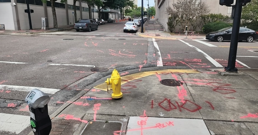
Situated within the urban confines of a city block, our project faced a formidable challenge – the densely populated space was intertwined with numerous power duct banks, water and sewer lines, a network of gas pipelines, and dozens of fiber conduits, all closely packed with minimal room to squeeze in the proposed new chilled water lines.
Due to the dense urban setting and its proximity to the Duval County Courthouse, there was a large amount of vehicular and pedestrian traffic to control and maintain an open path for while we excavated the potential conflict verification test holes. Complicating matters further, we could not work at night to avoid the traffic because of residential noise restrictions.
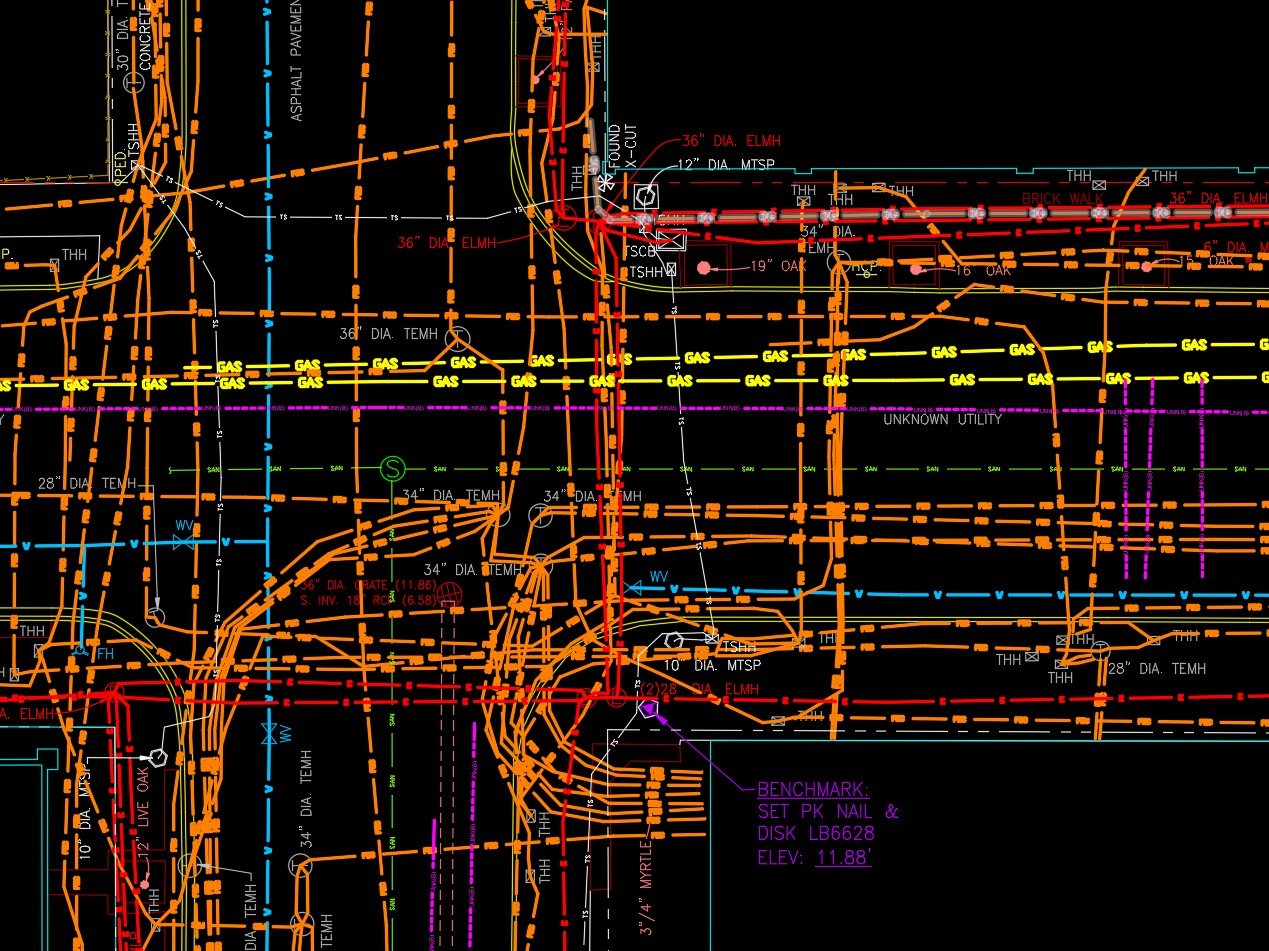
DRMP identified a staggering 97 utility lines within a block and a half and performed vacuum excavation at 65 test hole locations to provide the engineers with verified vertical and horizontal (VVH) test hole reports on the utilities identified as potential conflicts. The task demanded extraordinary precision from our SUE field crews, considering the vast array of utilities, each varying in generational and material composition.
The sheer volume of 97 underground lines for a single block surpassed the norm, even in downtown areas known for urban congestion. This presented a unique set of challenges. The Project Site is 700 linear feet in length, and a total of 14,425 linear feet of underground utilities were identified and marked. This number does not include the sanitary and stormwater gravity systems.
After the utilities were marked on the surface, survey crews came through and collected the data. The Survey was drafted in AutoCAD Civil 3D and provided to the Design Team to analyze and design a new path of least resistance for the construction of new lines.
Utility Line Detection Methods
The main two methods used to detect underground utility lines from the surface are the deployment of electromagnetic locators (EM) and ground penetrating radar (GPR). These are known as surface geophysical techniques and are long-standing standards employed for mapping utilities.
EM locators trace underground utilities, such as pipes, cables, and other conductive facilities. We place a high frequency tone on the structures at a connection point that we can detect with a receiver from the surface to pick up the signals emitted from the targeted lines along their path. This method is only effective at detecting metallic utilities that can conduct electricity as opposed to non-metallic utilities. When detecting non-metallic utilities or older degraded utilities that have become poor conductors, other technologies, such as ground penetrating radar (GPR), must be used.
GPR systems come in all shapes and sizes and all broadcast a radar signal into the ground, some of which bounces back off the utilities and other structures. These signals must be analyzed by an experienced technician to delineate non-conductive utilities from the surface.
We used all available methods of detection for this project and did a lot of climbing around the basement of the buildings to isolate each of the utility lines. There were hundreds of utility lines, but we marked 97 with paint above ground because many of the lines were going to the same duct banks.
Extensive Coordination
This project required extensive coordination with the buildings’ management teams to secure access to the basements flanking both sides of the block, the apartments, and the fiber hub, where utilities were accessed for detecting out into the street.
The project was completed on a tight timeline due to budget constraints because it was the end of the fiscal year for the client. We had two weeks of field time for the mapping of the utilities and another three weeks of vacuum excavation, a second phase to excavate and verify the utilities to make sure there was enough room to put the new utility lines in.
This was an intense job that required skill and expertise. In the sweltering climate of Florida, it brings us satisfaction to know that our efforts will contribute to making the lives of our residents a little more comfortable and cooler.
Ryan M. Grab, CST II, serves as an Assistant Subsurface Utility Engineering (SUE) Division Manager for DRMP’s Survey and Mapping/Geospatial Market Sector.
Posted in the categories All, Subsurface Utility Engineering, Surveying & Mapping, Utilities Engineering.

Categories
- All
- Featured Posts
- Alternative Delivery
- Construction Services
- Ecological Services
- Geographic Information Systems
- Land Development
- Structural Engineering
- Subsurface Utility Engineering
- Surveying & Mapping
- Transportation
- Water Resources/Stormwater Management
- Federal Services
- Project Development & Environment
- NEPA
- Transportation Planning/Project Development
- Utilities Engineering
Contributors
- Michael K. Albano, PE
- Bruno J. Arriola, PE, ENV SP
- Martha Ayers
- Brent Bass, PE, PSM
- Cody Bayer, PE
- Donald W. Brown, PE
- Kyle Brown, PE
- Michael Bywaletz, PE, CPESC, ENV SP
- Zach J. Carnahan, PE
- Brian Crowl, PE
- Patrick Day, PE
- Nick DeVito, PE
- Matt Floyd, PSM
- Deshon M. Fox, PE
- Scott Garth, PE, LEED AP ND
- Ryan M. Grab, CST II
- Robyn Hartz
- TJ Lallathin, Jr., PE, DBIA
- Kelly Marton, GISP
- Meaghan McCarthy
- George McLatchey, PWS, CEP
- Shawn McLemore, PE
- Jeff Miller
- Ryan Mitchell, PE
- Lisa Moon, PE
- Megan E. Mott, PE
- Josh Norman
- Julian Poole, PE
- Mark Prochak, PE
- Abby Rains
- Leo Rodriguez, PE
- Kimberly Santiago-Ortiz, PE
- Rachel L. Schmidt, PWS
- Logan Shappell
- Brian V. Smith
- Rynal Stephenson, PE
- Deston Taylor, EI
- August Thick, PLS
- Ron Wallace, PE
- Steven L. Wallace, PE
- Orville Williams
- Amanda E. Woods, PE


