- Discover
-
Expertise
-
Alternative Delivery
- I-275 at I-4 Downtown Tampa Interchange Design-Build
- Wekiva Parkway Section 8 Interchange
- US 17/92 Interchange at SR 436
- SR 9B Extension from I-95 to US 1
- A. Max Brewer Bridge Replacement
- I-95 Widening from the Indian River/Brevard County Line to Malabar Road
- SR 528 (Beachline Expressway) at Innovation Way Interchange
- SR 570 Polk Parkway Widening from I-4 to Pace Road
- I-95 Express Lanes and Ramp Signals – Phase 3A-1
- Pollard Road Extension over Peace Creek
- I-485 Widening from I-77 to Rea Road
- Monroe Bypass/Connector Design-Build
- Construction Services
- Ecological Services
-
Federal Services
- Range of the Future Study
- US Coast Guard Air Station (Clearwater)
- Ascension Island Fire Station Renovation
- Patrick Space Force Base Water Lines Repair
- Patrick Space Force Base Living Shoreline Restoration
- P-505 Electrical Hardening and Black Start CHP at Marine Corps Air Station Beaufort
- Naval Station at Guantanamo Bay Survey Services
- Repair Phillips Parkway and Speed Limit Study
- Ascension Island Auxiliary Airfield Surveying and Mapping Services
-
Geographic Information Systems (GIS)
- Thermal Design/Comprehensive Campus LiDAR Collection
- Greater Orlando Aviation Authority (GOAA) Strategic Commerical Land Development Program
- University of Florida Sanitary Sewer GIS Mapping
- Ascension Island Auxiliary Airfield GIS Integration
- Santa Rosa County School District's School Transportation & Capacity GIS Analysis
- Gainesville Community Redevelopment Agency Socioeconomic Analysis and Site Suitability Report
- Real Estate Site Suitability and Development Analysis
- SR 836 (Dolphin Expressway) GIS Asset Inventory of Pre-Post Construction
- Alachua County Public Schools GIS and School Planning Professional Services
- Patrick Air Force Base Living Shoreline Restoration GIS Analysis
- Florida Army National Guard Readiness Center GIS Inventory & Integration
- Comprehensive Transit Study Puerto Rico GIS Analysis
- Land Development
- Structural Engineering
-
Subsurface Utility Engineering (SUE)
- Thermal Design/Comprehensive Campus LiDAR Collection
- P-505 Electrical Hardening and Black Start CHP at Marine Corps Air Station Beaufort
- Resurface & Safety Improvements Turnpike Mainline
- University of Florida Rabon Utility Mapping
- FP&L Subsurface Utility Engineering Continuing On-Call Contract
- Lockheed Martin Subsurface Utility Engineering Services
- Palm Coast Parkway Subsurface Utility Engineering Services
- Surveying & Mapping/Geospatial
-
Traffic Impact Analysis
- 505 West Chapel Hill Street
- 5th Street Station
- Beale Farm Industrial Park
- Blue Mountain Mist Resort
- The Villages at McCullers Walk
- Fredericksburg National Baseball Stadium
- Hendrick Southpoint Auto Mall
- Apex Friendship Elementary School
- Whole Foods Center
- Barclay West
- Grove 98
- Pullen Drive Extension/Catholic Diocese
- Trails/Parks & Recreation Facilities
- Transportation
-
Utilities Engineering
- Ascension Island Fire Station Renovation
- M-1 Canal Water Main Extension
- 5th Street Bridge Utility Replacement
- Captain’s Cove Wastewater Plant Revisions & Permit Renewal
- City of Fort Myers Downtown Utility & Streetscape Improvement
- Florida Caverns State Park Lift Station Rehab
- Tween Waters Inn Wastewater Plant Permit Renewal
- City of Fort Myers Wastewater Capacity Studies
- Patrick Air Force Base Water Lines Repair
- Big Lagoon Boat Ramp Wastewater System
- St. Joseph State Park Septic Tank Replacement
- WildBlue Development Wastewater Modeling
- A-1 Gator Wastewater Capacity Increase
- Visualization Services
- Water Resources/Stormwater Management
-
Alternative Delivery
- Careers
- News
- #DRMPerspective
- Team With Us
- Locations

DRMP’s Surveying Experts Use Technology and Outreach to Encourage Students to Join the Profession
February 16th, 2023


Amidst a global effort to inspire the next generation of young professionals to become land surveyors, mappers, and geospatial experts, DRMP is doing its part by investing in STEM education and proactively participating in community outreach.
DRMP Advanced Survey Technology Department Manager Brent Bass, PE, SIT, is reaching students through interactive, hands-on technology, while Survey Analyst Melissa Padilla Cintron, SIT, became a volunteer Brand Ambassador for Get Kids into Survey - a Manchester, England-based global initiative to attract students to the land surveying profession.
Get Kids into Survey launched in 2017 in response to a shortage of skilled young surveyors in the United Kingdom. The United States also is experiencing shortages as industry experts reach retirement age with no one to fill the void of training the next generation of land surveyors. Changes in education and licensing qualifications for surveyors have also created recruitment barriers.
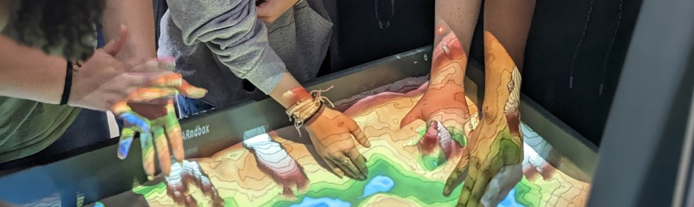
Playing in the Sandbox
To spark interest in the profession, Bass, and Survey and Mapping Project Manager Bryant King, recently introduced DRMP’s Augmented Reality (AR) Sandbox at Construction Career Days (CCD) in Orlando, Fla.
The CCD event took place at the Central Florida Fairgrounds and drew 3,200 students from area schools.
“Our Survey presentation focused on surveying as a competitive job in our industry and how DRMP invests in its employees and technology,” Bass said. “We explained our branch of surveying (LiDAR) and helped students understand what it is and how we do it.”
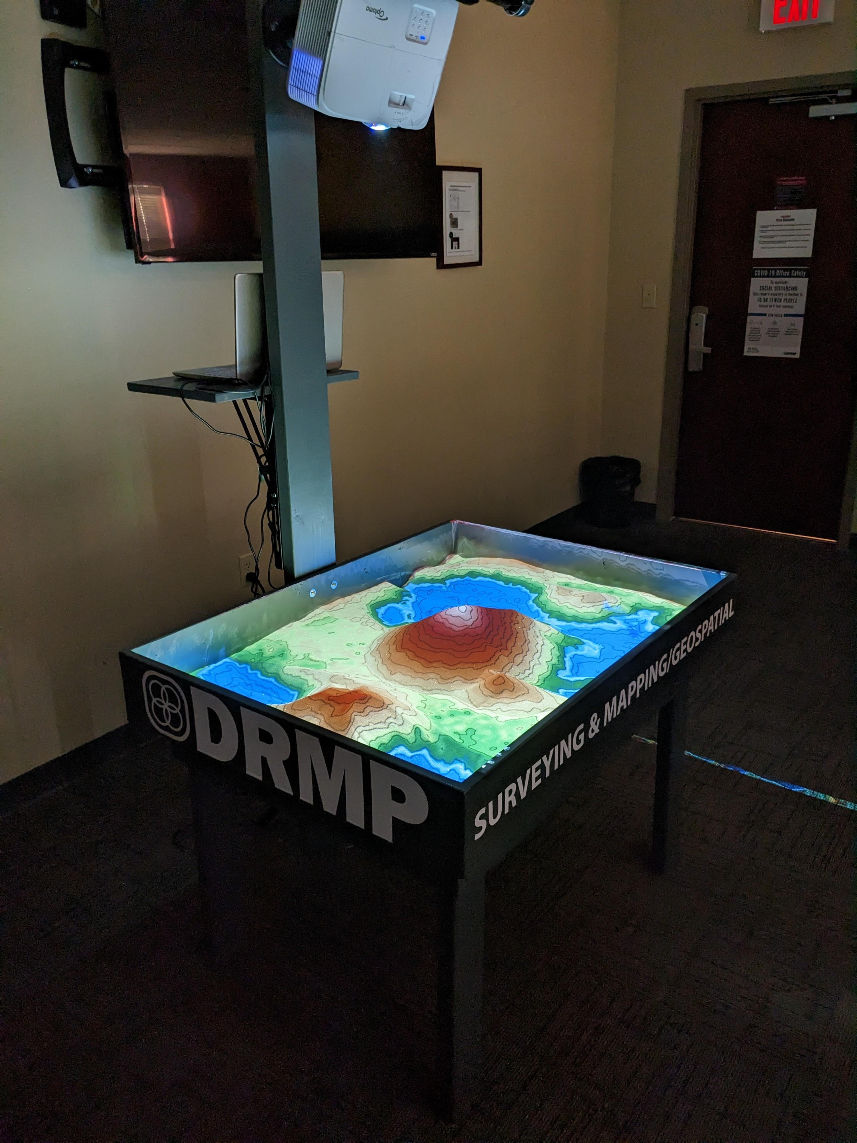
The sandbox is a 3D, interactive educational tool that allows users to create topography models by shaping real sand, which is then augmented in real-time by an elevation color map, topographic contour lines, and simulated water. The primary purpose of DRMP’s AR sandbox is to educate students and interns about surveying and mapping, as well as use it as a cross-training tool for DRMP employees.
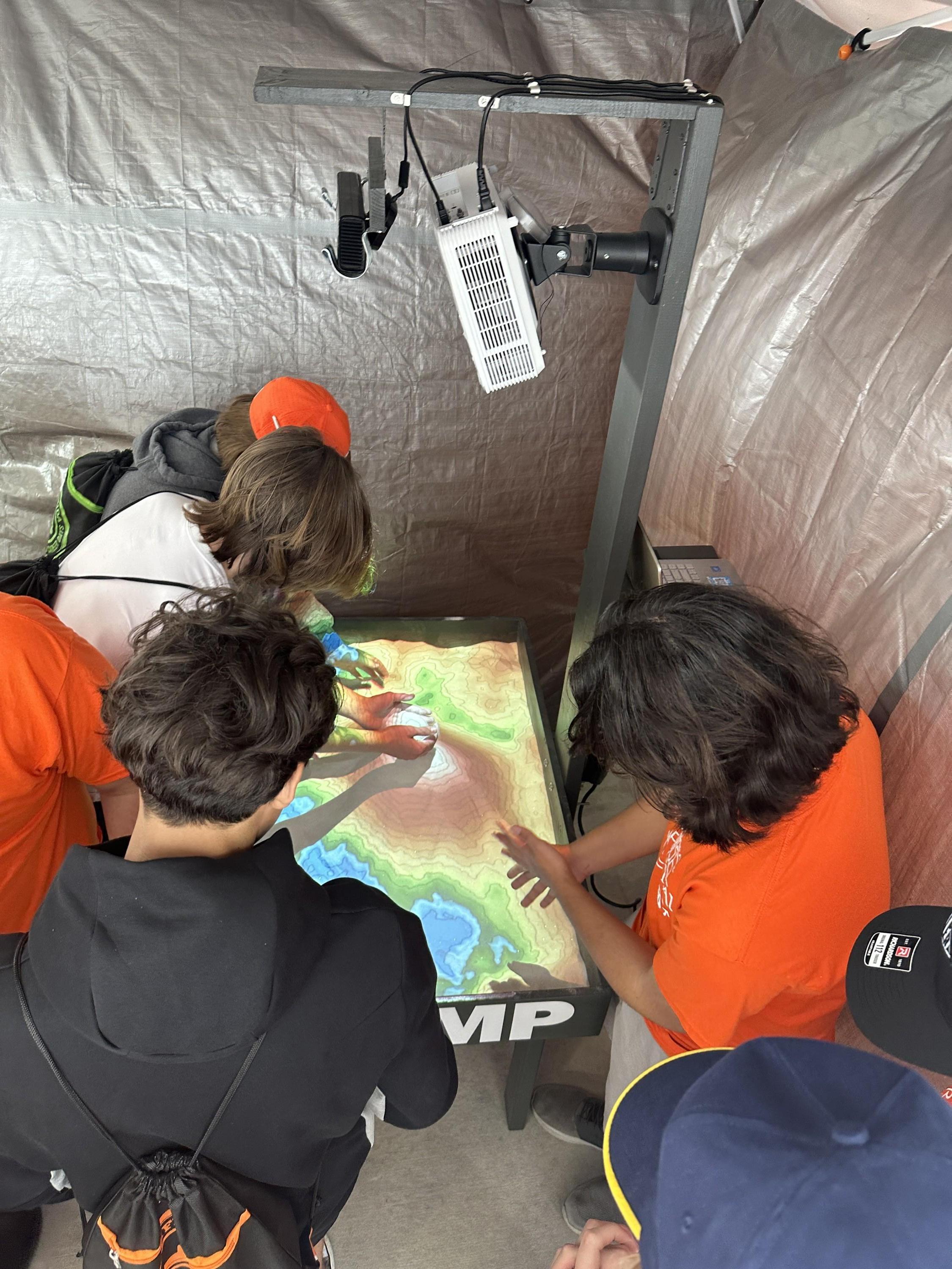
The sandbox works by using a combination of a real sandbox, a Kinect 360 camera, sandbox visualization software, and a short throw projector.
DRMP’s sandbox used about 100 pounds of special indoor sand that’s free of silica and safe to use, Bass explained. The sandbox uses the Kinect camera to check the depth changes of the sand. Every second it updates and refreshes the visualization on the computer. Then the latest changes are projected onto the sand creating the effect of changing contour lines.
“Near the end of the presentation, we talked about the final product of a design survey, which is terrain models and contours,” Bass said. “Then we had the students come over to the AR sandbox and manipulate the sand to see how contours work and how they can be affected if we change the terrain. The students seemed to really enjoy this part, and you could see their faces light up with excitement. You could almost see lightbulbs going off that they ‘get it’ now.”
Bass said some of the students had seen an AR sandbox before, but a majority had not.
“By having them actually move the “Earth” with their own hands really helps to explain what and why we do what we do,” Bass said. “Some of our survey staff have already used the sandbox to explain how we could locate ditches and swells better in the field to more accurately represent the terrain in their final models.”
DRMP’s Surveying and Mapping/Geospatial Director Joe Di Benedetto, PLS, tasked Bass with building the sandbox. The plan is to use the sandbox for survey training, high school STEM nights/Career Days, and college intern recruitment.
“It has such a wow factor in educating that Joe wanted this to be something we utilize to teach and spark some interest in young people for surveying,” Bass said.
The idea of the sandbox was perfected by the University of California, Davis, in 2012, which helped create an open-source option for groups to build their own sandbox, Bass said.
“At some point we would like to test other software and possibly use the sandbox for subsurface utility education and LiDAR visualization,” he said.
Getting Kids into Survey
DRMP’s Survey Analyst Melissa Padilla Cintron is inspiring students to consider the land surveying and mapping profession through interactive school presentations and resources, such as comic books and posters supplied by Get Kids into Survey.
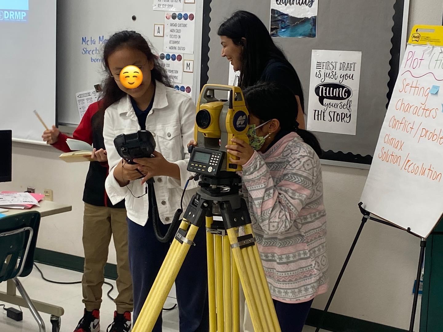
She joined the organization as a brand ambassador in 2022 and represented DRMP and Get Kids into Survey at the Great American Teach-In in November of that same year. Padilla Cintron conducted a surveying presentation at Liberty Middle School in Tampa, Fla., and brought a total station, data collector, and rod, into the classroom to demonstrate to students how surveying works.
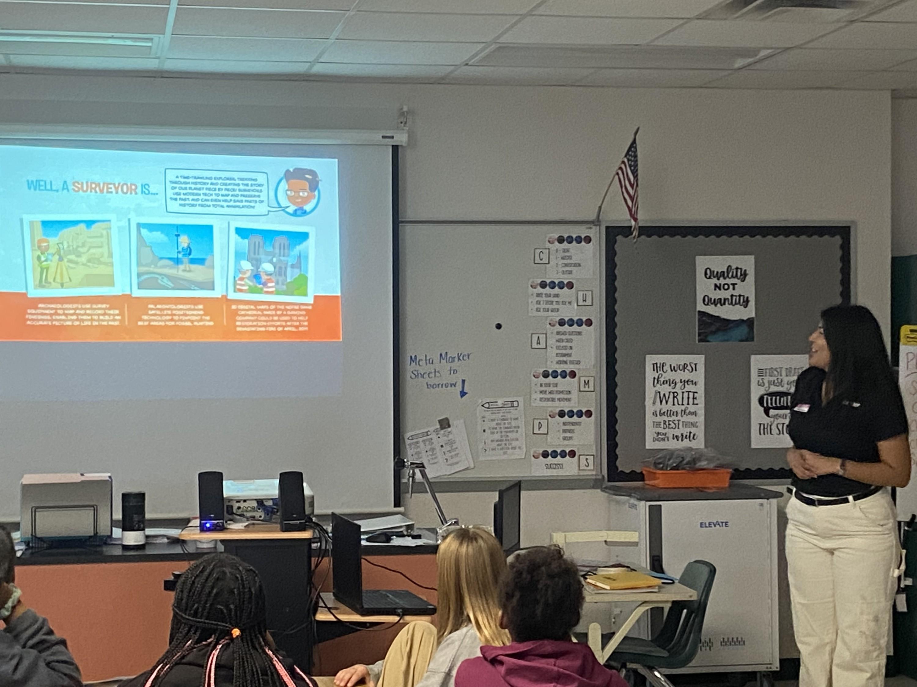
"I did a dynamic presentation combining hands-on experience using the posters the Get Kids into Survey provided and showed students different types of instruments and their function on a job site,” Padilla Cintron said. “We also measured around the classroom the distance from one point to another to show them how the surveying equipment works. They loved it. Some of them expressed they had seen us with our equipment on the side of the road, but they didn’t understand what we do.
“One female student said she wanted to be a surveyor in the future,” Padilla Cintron continued. “I told her we needed more women in the industry because female surveyors are not common.”
Padilla Cintron also will participate in Construction Career Days in Tampa in March during National Surveyors Week. Along with bringing equipment for a demonstration, Padilla Cintron reached out to a representative from the University of Florida to attend the event with her to talk to students about the university’s surveying program options.
“I do plan to do additional presentations during Surveyors Week in the schools or do an outreach event with DRMP,” she said. “I think it’s important we are getting involved with the community and using technology, such as the AR sandbox to explain our profession. I think we are impacting kids and students, so they know they have career options, and survey is one of them.”
The global and local efforts to close the gap in the shortage of surveying professionals is being taken seriously. Salaries have gone up in recent years to attract applicants, and projects like Get Kids into Survey have organized internationally and locally to engage the next generation of young professionals. DRMP will continue to look for opportunities to shine a spotlight on the importance of the profession through investment in technology, talent acquisition, STEM education, and community outreach.
.jpg?v=1676554455669)
Brent Bass, PE, PSM, is an Advanced Survey Technology Department Manager in DRMP's Surveying and Mapping/Geospatial Department.
Share This Page![]()


.jpg?v=1676554747753)
Melissa Padilla Cintron, SIT, is a Survey Analyst in DRMP’s Surveying and Mapping/Geospatial Department.
Share This Page![]()
Posted in the categories All, Surveying & Mapping.

Categories
- All
- Featured Posts
- Alternative Delivery
- Construction Services
- Ecological Services
- Geographic Information Systems
- Land Development
- Structural Engineering
- Subsurface Utility Engineering
- Surveying & Mapping
- Transportation
- Water Resources/Stormwater Management
- Federal Services
- Project Development & Environment
- NEPA
- Transportation Planning/Project Development
- Utilities Engineering
Contributors
- Michael K. Albano, PE
- Bruno J. Arriola, PE, ENV SP
- Martha Ayers
- Brent Bass, PE, PSM
- Cody Bayer, PE
- Donald W. Brown, PE
- Kyle Brown, PE
- Michael Bywaletz, PE, CPESC, ENV SP
- Zach J. Carnahan, PE
- Brian Crowl, PE
- Patrick Day, PE
- Nick DeVito, PE
- Matt Floyd, PSM
- Deshon M. Fox, PE
- Scott Garth, PE, LEED AP ND
- Ryan M. Grab, CST II
- Robyn Hartz
- TJ Lallathin, Jr., PE, DBIA
- Kelly Marton, GISP
- Meaghan McCarthy
- George McLatchey, PWS, CEP
- Shawn McLemore, PE
- Jeff Miller
- Ryan Mitchell, PE
- Lisa Moon, PE
- Megan E. Mott, PE
- Josh Norman
- Julian Poole, PE
- Mark Prochak, PE
- Abby Rains
- Leo Rodriguez, PE
- Kimberly Santiago-Ortiz, PE
- Rachel L. Schmidt, PWS
- Logan Shappell
- Brian V. Smith
- Rynal Stephenson, PE
- Deston Taylor, EI
- August Thick, PLS
- Ron Wallace, PE
- Steven L. Wallace, PE
- Orville Williams
- Amanda E. Woods, PE


