- Discover
-
Expertise
-
Alternative Delivery
- I-275 at I-4 Downtown Tampa Interchange Design-Build
- Wekiva Parkway Section 8 Interchange
- US 17/92 Interchange at SR 436
- SR 9B Extension from I-95 to US 1
- A. Max Brewer Bridge Replacement
- I-95 Widening from the Indian River/Brevard County Line to Malabar Road
- SR 528 (Beachline Expressway) at Innovation Way Interchange
- SR 570 Polk Parkway Widening from I-4 to Pace Road
- I-95 Express Lanes and Ramp Signals – Phase 3A-1
- Pollard Road Extension over Peace Creek
- I-485 Widening from I-77 to Rea Road
- Monroe Bypass/Connector Design-Build
- Construction Services
- Ecological Services
-
Federal Services
- Range of the Future Study
- US Coast Guard Air Station (Clearwater)
- Ascension Island Fire Station Renovation
- Patrick Space Force Base Water Lines Repair
- Patrick Space Force Base Living Shoreline Restoration
- P-505 Electrical Hardening and Black Start CHP at Marine Corps Air Station Beaufort
- Naval Station at Guantanamo Bay Survey Services
- Repair Phillips Parkway and Speed Limit Study
- Ascension Island Auxiliary Airfield Surveying and Mapping Services
-
Geographic Information Systems (GIS)
- Thermal Design/Comprehensive Campus LiDAR Collection
- Greater Orlando Aviation Authority (GOAA) Strategic Commerical Land Development Program
- University of Florida Sanitary Sewer GIS Mapping
- Ascension Island Auxiliary Airfield GIS Integration
- Santa Rosa County School District's School Transportation & Capacity GIS Analysis
- Gainesville Community Redevelopment Agency Socioeconomic Analysis and Site Suitability Report
- Real Estate Site Suitability and Development Analysis
- SR 836 (Dolphin Expressway) GIS Asset Inventory of Pre-Post Construction
- Alachua County Public Schools GIS and School Planning Professional Services
- Patrick Air Force Base Living Shoreline Restoration GIS Analysis
- Florida Army National Guard Readiness Center GIS Inventory & Integration
- Comprehensive Transit Study Puerto Rico GIS Analysis
- Land Development
- Structural Engineering
-
Subsurface Utility Engineering (SUE)
- Thermal Design/Comprehensive Campus LiDAR Collection
- P-505 Electrical Hardening and Black Start CHP at Marine Corps Air Station Beaufort
- Resurface & Safety Improvements Turnpike Mainline
- University of Florida Rabon Utility Mapping
- FP&L Subsurface Utility Engineering Continuing On-Call Contract
- Lockheed Martin Subsurface Utility Engineering Services
- Palm Coast Parkway Subsurface Utility Engineering Services
- Surveying & Mapping/Geospatial
-
Traffic Impact Analysis
- 505 West Chapel Hill Street
- 5th Street Station
- Beale Farm Industrial Park
- Blue Mountain Mist Resort
- The Villages at McCullers Walk
- Fredericksburg National Baseball Stadium
- Hendrick Southpoint Auto Mall
- Apex Friendship Elementary School
- Whole Foods Center
- Barclay West
- Grove 98
- Pullen Drive Extension/Catholic Diocese
- Trails/Parks & Recreation Facilities
- Transportation
-
Utilities Engineering
- Ascension Island Fire Station Renovation
- M-1 Canal Water Main Extension
- 5th Street Bridge Utility Replacement
- Captain’s Cove Wastewater Plant Revisions & Permit Renewal
- City of Fort Myers Downtown Utility & Streetscape Improvement
- Florida Caverns State Park Lift Station Rehab
- Tween Waters Inn Wastewater Plant Permit Renewal
- City of Fort Myers Wastewater Capacity Studies
- Patrick Air Force Base Water Lines Repair
- Big Lagoon Boat Ramp Wastewater System
- St. Joseph State Park Septic Tank Replacement
- WildBlue Development Wastewater Modeling
- A-1 Gator Wastewater Capacity Increase
- Visualization Services
- Water Resources/Stormwater Management
-
Alternative Delivery
- Careers
- News
- #DRMPerspective
- Team With Us
- Locations

Designing a Major Water Control Structure Using a Cost-Effective and Efficient Approach
July 12th, 2023


We were honored to have the opportunity to design a major water control structure serving the mid-region of Palm Coast, Fla., that is more cost effective and efficient and will save taxpayer dollars in the long run.
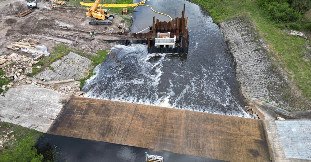
The control structure, located in the Lehigh Canal a half mile west of I-95, will replace an existing failed structure and help prevent flooding. It is an important structure because it has the largest drainage basin area – 10,676 acres – of all City control structures and controls the most amount of water in the entire city.
As hurricane season is underway in Florida, our design of the new L-4 surface water control structure in Palm Coast is under construction and nearing completion. The new structure will allow the city to draw down water levels quicker from its canal system ahead of a severe storm.
Contractors build a new weir structure designed by DRMP for the City of Palm Coast, Fla.
Our firm’s design of the new structure provides an upgraded water control system and keeps the public safer during a storm. It is more cost-effective, hydraulically efficient, and will have a longer service life than the City’s existing structure. It also will provide better access for maintenance and has a mechanical system for the weir gates, which allows the City to control it remotely.
Existing Structure Failures
The standard city water drawn down system is a single corrugated metal riser culvert with a 6-foot-long operable weir mounted to the front, such as the existing L-4 system. These structures control water levels, so when it storms, a basin has room to hold rainwater, preventing neighborhoods and commercial properties from flooding.
The existing structure over the years experienced several failures, which led the City to completely replace it, and later when it started to wash out, apply temporary fixes to it. On one occasion the city used 105 cubic yards of flowable fill to stabilize the washed-out structure. When the interior of the structure started to wash away, the city could not determine how seepage into the structure was occurring.
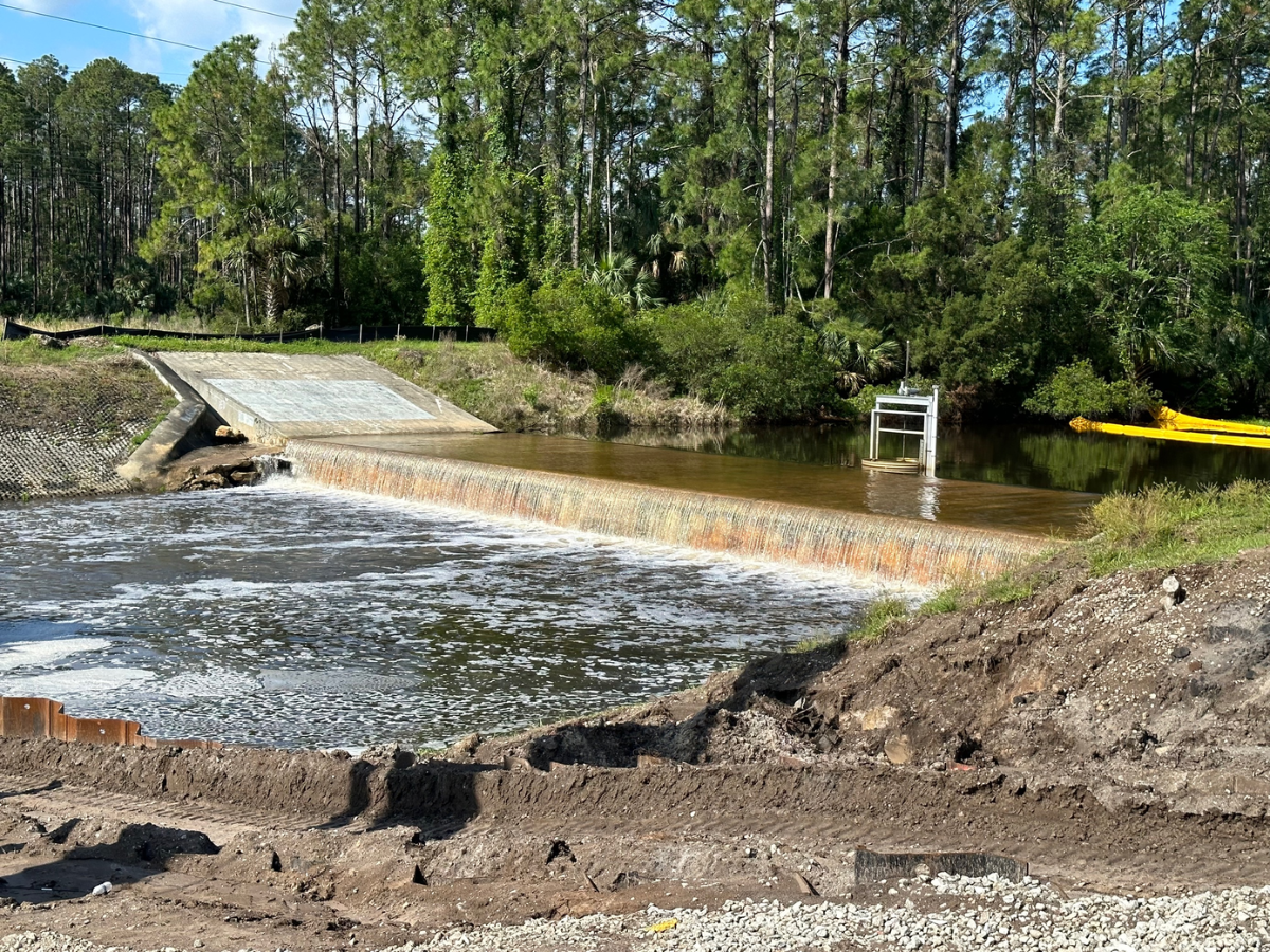
The old weir structure in the City of Palm Coast, Fla., pictured above has experienced many failures over the years.
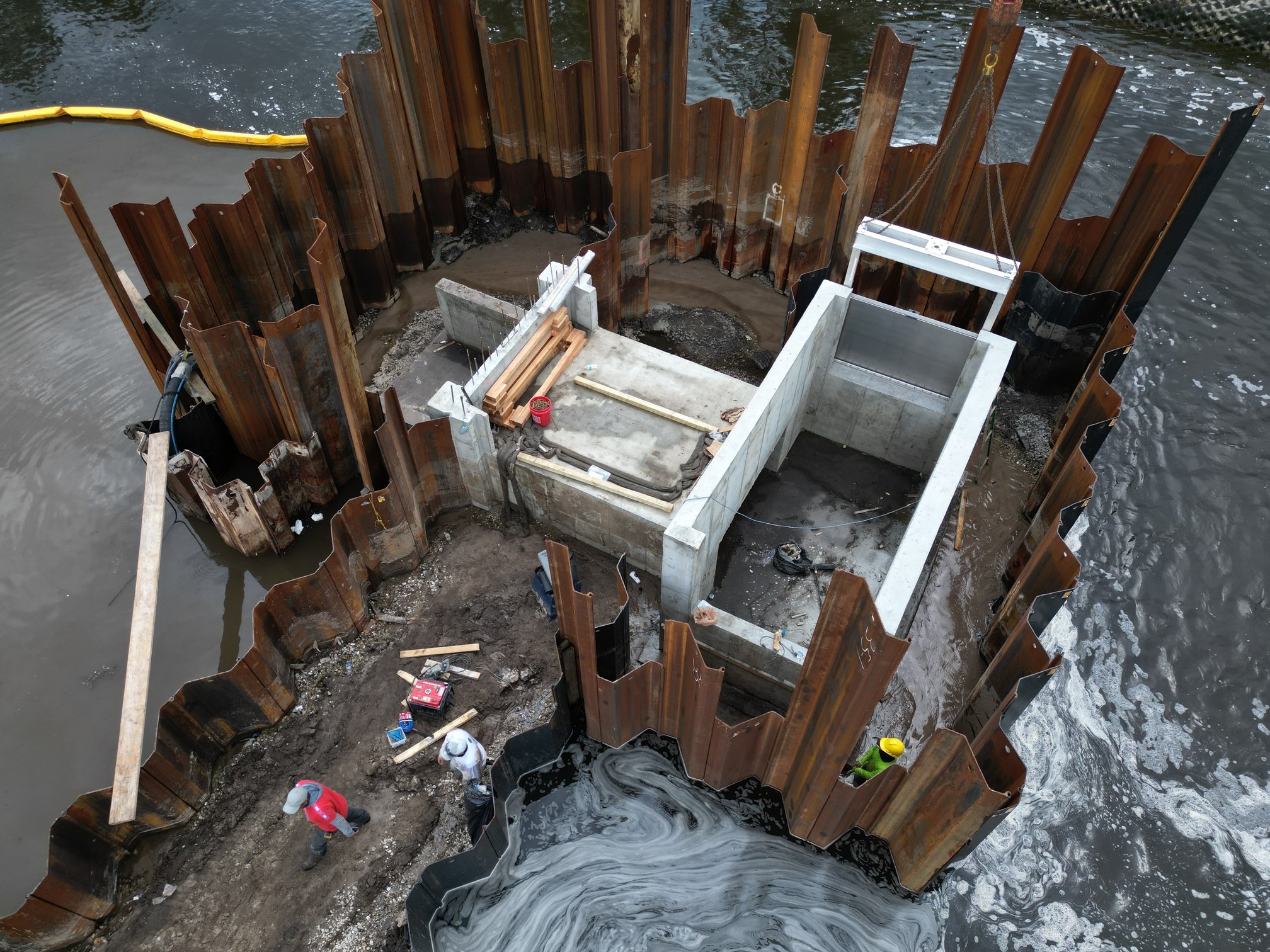
Through drawn down analysis, DRMP determined increasing the operable weir gate setup from one 6-foot-wide gate to four 6-foot gates would achieve the city’s desired water level control of 4 feet of drawdown within 48 hours prior to a storm. The normal water level in the canal will be kept at elevation 18 (NAVD88 feet) on a regular basis and adjusted based on weather conditions.
In addition, between four separate metal risers and a single concrete riser with four gates, the City chose the concrete alternative instead of metal as this option provides improved access to the gates during high water/flow conditions and longer design service life. With the existing structure, there’s a space between the concrete pad and metal riser so field workers have to reach over and across the water to perform maintenance. The new structure allows safer and easier access.
New Design Capabilities
Our team designed the new L-4 control structure with a single box culvert barrel. We moved two of the weir openings to the sides of the structure and narrowed the width of the concrete overflow weir and sloped the top slab, which allows for a reduction in the footprint of the structure and has fewer environmental impacts. The sloped top slab pushes water away and keeps the concrete dry, so it doesn’t deteriorate.
The gate that allows the water to go in and out of the structure can be controlled remotely so city personnel do not have to go there in person. The existing structure does not have this capability or any mechanical aspect to it.
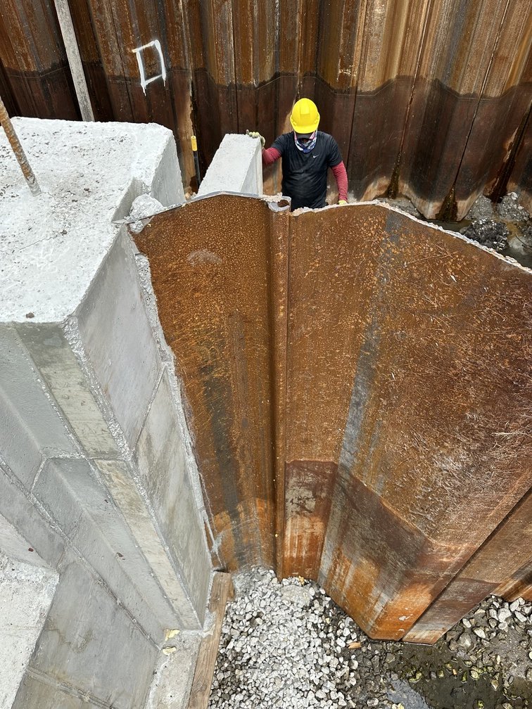
A contractor inspects sheet pile alignment during installation of a new weir structure in the City of Palm Coast, Fla.
Combining watershed-scale modeling capabilities with design of a major water control structure with remote control of automatic weir gates required a broad range of expertise from our firm. Our project team included experts in surface water modeling, structural design, geotechnical investigation, and construction, engineering, and inspection (CEI).
The project also required coordination and permitting with the St. Johns River Water Management District (SJRWMD) due to other surface waters (OSW) impacts.
Being located in a state frequently hit by hurricanes and thunderstorms, designing a more efficient and structurally sound water control structure for the City of Palm Coast makes this project even more critical and rewarding.

Kimberly Santiago-Ortiz, PE, is a Project Engineer in DRMP’s Water Resources Division.
Share This Page![]()


Posted in the categories All, Structural Engineering, Water Resources/Stormwater Management , Utilities Engineering.

Categories
- All
- Featured Posts
- Alternative Delivery
- Construction Services
- Ecological Services
- Geographic Information Systems
- Land Development
- Structural Engineering
- Subsurface Utility Engineering
- Surveying & Mapping
- Transportation
- Water Resources/Stormwater Management
- Federal Services
- Project Development & Environment
- NEPA
- Transportation Planning/Project Development
- Utilities Engineering
Contributors
- Michael K. Albano, PE
- Bruno J. Arriola, PE, ENV SP
- Martha Ayers
- Brent Bass, PE, PSM
- Cody Bayer, PE
- Donald W. Brown, PE
- Kyle Brown, PE
- Michael Bywaletz, PE, CPESC, ENV SP
- Zach J. Carnahan, PE
- Brian Crowl, PE
- Patrick Day, PE
- Nick DeVito, PE
- Matt Floyd, PSM
- Deshon M. Fox, PE
- Scott Garth, PE, LEED AP ND
- Ryan M. Grab, CST II
- Robyn Hartz
- TJ Lallathin, Jr., PE, DBIA
- Kelly Marton, GISP
- Meaghan McCarthy
- George McLatchey, PWS, CEP
- Shawn McLemore, PE
- Jeff Miller
- Ryan Mitchell, PE
- Lisa Moon, PE
- Megan E. Mott, PE
- Josh Norman
- Julian Poole, PE
- Mark Prochak, PE
- Abby Rains
- Leo Rodriguez, PE
- Kimberly Santiago-Ortiz, PE
- Rachel L. Schmidt, PWS
- Logan Shappell
- Brian V. Smith
- Rynal Stephenson, PE
- Deston Taylor, EI
- August Thick, PLS
- Ron Wallace, PE
- Steven L. Wallace, PE
- Orville Williams
- Amanda E. Woods, PE


