- Discover
-
Expertise
-
Alternative Delivery
- I-275 at I-4 Downtown Tampa Interchange Design-Build
- Wekiva Parkway Section 8 Interchange
- US 17/92 Interchange at SR 436
- SR 9B Extension from I-95 to US 1
- A. Max Brewer Bridge Replacement
- I-95 Widening from the Indian River/Brevard County Line to Malabar Road
- SR 528 (Beachline Expressway) at Innovation Way Interchange
- SR 570 Polk Parkway Widening from I-4 to Pace Road
- I-95 Express Lanes and Ramp Signals – Phase 3A-1
- Pollard Road Extension over Peace Creek
- I-485 Widening from I-77 to Rea Road
- Monroe Bypass/Connector Design-Build
- Construction Services
- Ecological Services
-
Federal Services
- Range of the Future Study
- US Coast Guard Air Station (Clearwater)
- Ascension Island Fire Station Renovation
- Patrick Space Force Base Water Lines Repair
- Patrick Space Force Base Living Shoreline Restoration
- P-505 Electrical Hardening and Black Start CHP at Marine Corps Air Station Beaufort
- Naval Station at Guantanamo Bay Survey Services
- Repair Phillips Parkway and Speed Limit Study
- Ascension Island Auxiliary Airfield Surveying and Mapping Services
-
Geographic Information Systems (GIS)
- Thermal Design/Comprehensive Campus LiDAR Collection
- Greater Orlando Aviation Authority (GOAA) Strategic Commerical Land Development Program
- University of Florida Sanitary Sewer GIS Mapping
- Ascension Island Auxiliary Airfield GIS Integration
- Santa Rosa County School District's School Transportation & Capacity GIS Analysis
- Gainesville Community Redevelopment Agency Socioeconomic Analysis and Site Suitability Report
- Real Estate Site Suitability and Development Analysis
- SR 836 (Dolphin Expressway) GIS Asset Inventory of Pre-Post Construction
- Alachua County Public Schools GIS and School Planning Professional Services
- Patrick Air Force Base Living Shoreline Restoration GIS Analysis
- Florida Army National Guard Readiness Center GIS Inventory & Integration
- Comprehensive Transit Study Puerto Rico GIS Analysis
- Land Development
- Structural Engineering
-
Subsurface Utility Engineering (SUE)
- Thermal Design/Comprehensive Campus LiDAR Collection
- P-505 Electrical Hardening and Black Start CHP at Marine Corps Air Station Beaufort
- Resurface & Safety Improvements Turnpike Mainline
- University of Florida Rabon Utility Mapping
- FP&L Subsurface Utility Engineering Continuing On-Call Contract
- Lockheed Martin Subsurface Utility Engineering Services
- Palm Coast Parkway Subsurface Utility Engineering Services
- Surveying & Mapping/Geospatial
-
Traffic Impact Analysis
- 505 West Chapel Hill Street
- 5th Street Station
- Beale Farm Industrial Park
- Blue Mountain Mist Resort
- The Villages at McCullers Walk
- Fredericksburg National Baseball Stadium
- Hendrick Southpoint Auto Mall
- Apex Friendship Elementary School
- Whole Foods Center
- Barclay West
- Grove 98
- Pullen Drive Extension/Catholic Diocese
- Trails/Parks & Recreation Facilities
- Transportation
-
Utilities Engineering
- Ascension Island Fire Station Renovation
- M-1 Canal Water Main Extension
- 5th Street Bridge Utility Replacement
- Captain’s Cove Wastewater Plant Revisions & Permit Renewal
- City of Fort Myers Downtown Utility & Streetscape Improvement
- Florida Caverns State Park Lift Station Rehab
- Tween Waters Inn Wastewater Plant Permit Renewal
- City of Fort Myers Wastewater Capacity Studies
- Patrick Air Force Base Water Lines Repair
- Big Lagoon Boat Ramp Wastewater System
- St. Joseph State Park Septic Tank Replacement
- WildBlue Development Wastewater Modeling
- A-1 Gator Wastewater Capacity Increase
- Visualization Services
- Water Resources/Stormwater Management
-
Alternative Delivery
- Careers
- News
- #DRMPerspective
- Team With Us
- Locations

DRMP's LiDAR Expertise Streamlines Morton Salt Plant Redesign in Unique Collaboration
November 1st, 2023


An hour away from DRMP’s Orlando, Fla., headquarters, Morton Salt produces more than 200,000 tons of swimming pool, premium water softener, and agricultural salts at its manufacturing plant in Cape Canaveral.
Up in Maumee, Ohio, our Trilon partner firm, Mannik & Smith Group (MSG), is developing a new floor plan for the Morton Salt plant in Florida with the assistance of DRMP as a subconsultant on the project.
Mobilizing resources on this project would have been difficult for MSG without collaboration from DRMP since the Ohio-based firm does not have offices in Florida. Our firm’s proximity to the Morton Salt plant combined with our LiDAR capabilities made this collaboration key to better serving the client.
This project also provided DRMP with a unique opportunity to perform work outside of our transportation market sector expertise.
DRMP’s LiDAR Capabilities
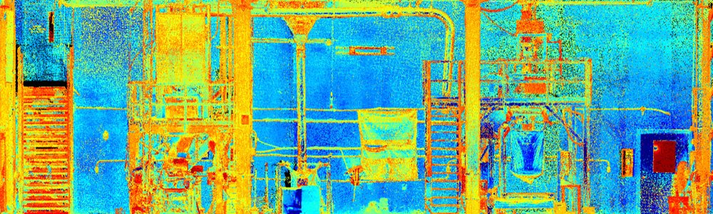
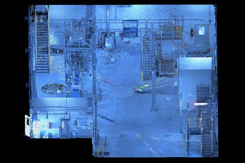
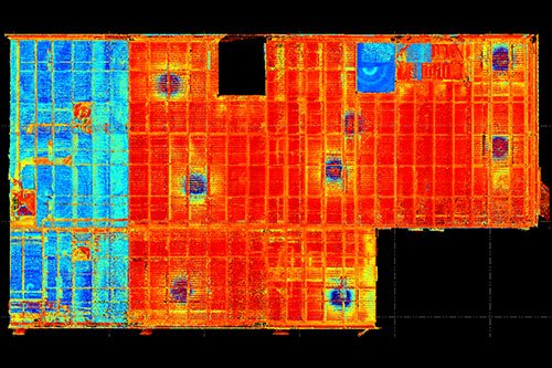
Our role in this project involved providing a static terrestrial LiDAR (light detection and ranging) scan of the existing layout of Morton Salt’s equipment to assist MSG with designing the new floor plan.
We used a Trimble X7 Terrestrial LiDAR sensor, a high-speed laser scanning system, to create a point cloud of the inside of the plant and provided it to MSG within two days.
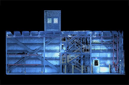
The LiDAR sensor emits rapid and short laser pulses to scan and map out an environment. When the emitted laser pulses hit objects in the environment, they get reflected toward the sensor. The terrestrial LiDAR sensor records the time it takes for the laser pulse to travel from the sensor to the object and back. This is known as the time of flight and is measured with high precision using accurate timing devices and in turn creates a point. Each point in a point cloud represents a single spatial measurement, but there are millions of points. By the time the scan is complete, it looks photo realistic because there are so many points.
Without LiDAR capabilities, conventional methods of measurement would be used in this case locating all the items manually with a Total Station. This method would have taken more time, and in turn, would have shut down the salt production facility for much longer, affecting the client’s operations.
A Rare Opportunity
This has been a unique, collaborative opportunity for us since DRMP specializes in Survey services for transportation projects. We typically use LiDAR for scanning bridges and other vertical features, but our deliverable is quite different on those types of projects compared to the Morton Salt project. For this project, we are delivering a point cloud to MSG without having to extract the data.
When working on transportation projects, we would collect the point cloud data, review it, and extract the information using computer-aided design software, such as MicroStation CAD or AutoCAD, or by generating a PDF plan set.
Our collaboration with MSG not only allowed for decreased mobilization time but also enabled our partner firm to seek work outside of its geographical location. This project is a great example of advantageous and efficient use of teamwork while delivering quality service to the client.
Matt Floyd, PSM, serves as the Boca Raton Survey Department Manager for DRMP’s Survey and Mapping/Geospatial Market Sector. .

Categories
- All
- Featured Posts
- Alternative Delivery
- Construction Services
- Ecological Services
- Geographic Information Systems
- Land Development
- Structural Engineering
- Subsurface Utility Engineering
- Surveying & Mapping
- Transportation
- Water Resources/Stormwater Management
- Federal Services
- Project Development & Environment
- NEPA
- Transportation Planning/Project Development
- Utilities Engineering
Contributors
- Michael K. Albano, PE
- Bruno J. Arriola, PE, ENV SP
- Martha Ayers
- Brent Bass, PE, PSM
- Cody Bayer, PE
- Donald W. Brown, PE
- Kyle Brown, PE
- Michael Bywaletz, PE, CPESC, ENV SP
- Zach J. Carnahan, PE
- Brian Crowl, PE
- Patrick Day, PE
- Nick DeVito, PE
- Matt Floyd, PSM
- Deshon M. Fox, PE
- Scott Garth, PE, LEED AP ND
- Ryan M. Grab, CST II
- Robyn Hartz
- TJ Lallathin, Jr., PE, DBIA
- Kelly Marton, GISP
- Meaghan McCarthy
- George McLatchey, PWS, CEP
- Shawn McLemore, PE
- Jeff Miller
- Ryan Mitchell, PE
- Lisa Moon, PE
- Megan E. Mott, PE
- Josh Norman
- Julian Poole, PE
- Mark Prochak, PE
- Abby Rains
- Leo Rodriguez, PE
- Kimberly Santiago-Ortiz, PE
- Rachel L. Schmidt, PWS
- Logan Shappell
- Brian V. Smith
- Rynal Stephenson, PE
- Deston Taylor, EI
- August Thick, PLS
- Ron Wallace, PE
- Steven L. Wallace, PE
- Orville Williams
- Amanda E. Woods, PE


