- Discover
-
Expertise
-
Alternative Delivery
- I-275 at I-4 Downtown Tampa Interchange Design-Build
- Wekiva Parkway Section 8 Interchange
- US 17/92 Interchange at SR 436
- SR 9B Extension from I-95 to US 1
- A. Max Brewer Bridge Replacement
- I-95 Widening from the Indian River/Brevard County Line to Malabar Road
- SR 528 (Beachline Expressway) at Innovation Way Interchange
- SR 570 Polk Parkway Widening from I-4 to Pace Road
- I-95 Express Lanes and Ramp Signals – Phase 3A-1
- Pollard Road Extension over Peace Creek
- I-485 Widening from I-77 to Rea Road
- Monroe Bypass/Connector Design-Build
- Construction Services
- Ecological Services
-
Federal Services
- Range of the Future Study
- US Coast Guard Air Station (Clearwater)
- Ascension Island Fire Station Renovation
- Patrick Space Force Base Water Lines Repair
- Patrick Space Force Base Living Shoreline Restoration
- P-505 Electrical Hardening and Black Start CHP at Marine Corps Air Station Beaufort
- Naval Station at Guantanamo Bay Survey Services
- Repair Phillips Parkway and Speed Limit Study
- Ascension Island Auxiliary Airfield Surveying and Mapping Services
-
Geographic Information Systems (GIS)
- Thermal Design/Comprehensive Campus LiDAR Collection
- Greater Orlando Aviation Authority (GOAA) Strategic Commerical Land Development Program
- University of Florida Sanitary Sewer GIS Mapping
- Ascension Island Auxiliary Airfield GIS Integration
- Santa Rosa County School District's School Transportation & Capacity GIS Analysis
- Gainesville Community Redevelopment Agency Socioeconomic Analysis and Site Suitability Report
- Real Estate Site Suitability and Development Analysis
- SR 836 (Dolphin Expressway) GIS Asset Inventory of Pre-Post Construction
- Alachua County Public Schools GIS and School Planning Professional Services
- Patrick Air Force Base Living Shoreline Restoration GIS Analysis
- Florida Army National Guard Readiness Center GIS Inventory & Integration
- Comprehensive Transit Study Puerto Rico GIS Analysis
- Land Development
- Structural Engineering
-
Subsurface Utility Engineering (SUE)
- Thermal Design/Comprehensive Campus LiDAR Collection
- P-505 Electrical Hardening and Black Start CHP at Marine Corps Air Station Beaufort
- Resurface & Safety Improvements Turnpike Mainline
- University of Florida Rabon Utility Mapping
- FP&L Subsurface Utility Engineering Continuing On-Call Contract
- Lockheed Martin Subsurface Utility Engineering Services
- Palm Coast Parkway Subsurface Utility Engineering Services
- Surveying & Mapping/Geospatial
-
Traffic Impact Analysis
- 505 West Chapel Hill Street
- 5th Street Station
- Beale Farm Industrial Park
- Blue Mountain Mist Resort
- The Villages at McCullers Walk
- Fredericksburg National Baseball Stadium
- Hendrick Southpoint Auto Mall
- Apex Friendship Elementary School
- Whole Foods Center
- Barclay West
- Grove 98
- Pullen Drive Extension/Catholic Diocese
- Trails/Parks & Recreation Facilities
- Transportation
-
Utilities Engineering
- Ascension Island Fire Station Renovation
- M-1 Canal Water Main Extension
- 5th Street Bridge Utility Replacement
- Captain’s Cove Wastewater Plant Revisions & Permit Renewal
- City of Fort Myers Downtown Utility & Streetscape Improvement
- Florida Caverns State Park Lift Station Rehab
- Tween Waters Inn Wastewater Plant Permit Renewal
- City of Fort Myers Wastewater Capacity Studies
- Patrick Air Force Base Water Lines Repair
- Big Lagoon Boat Ramp Wastewater System
- St. Joseph State Park Septic Tank Replacement
- WildBlue Development Wastewater Modeling
- A-1 Gator Wastewater Capacity Increase
- Visualization Services
- Water Resources/Stormwater Management
-
Alternative Delivery
- Careers
- News
- #DRMPerspective
- Team With Us
- Locations
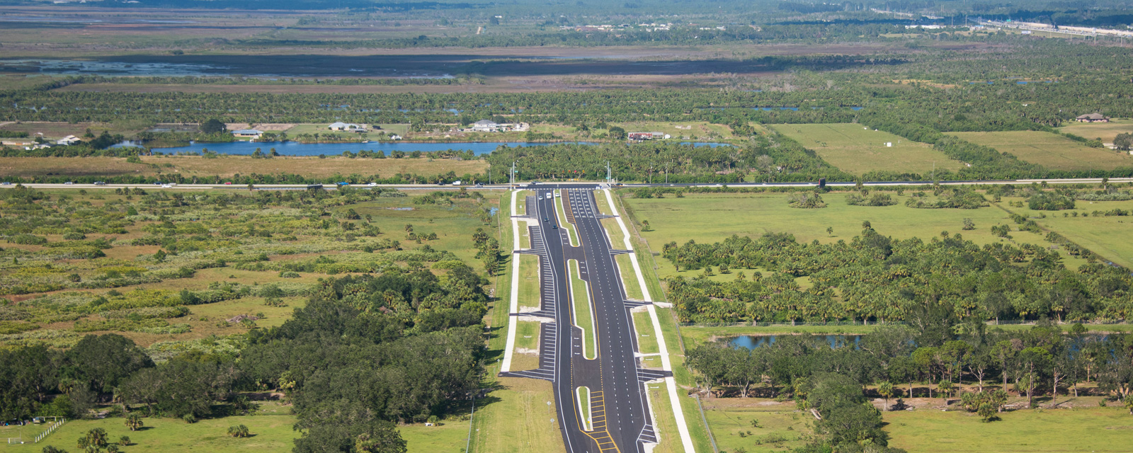
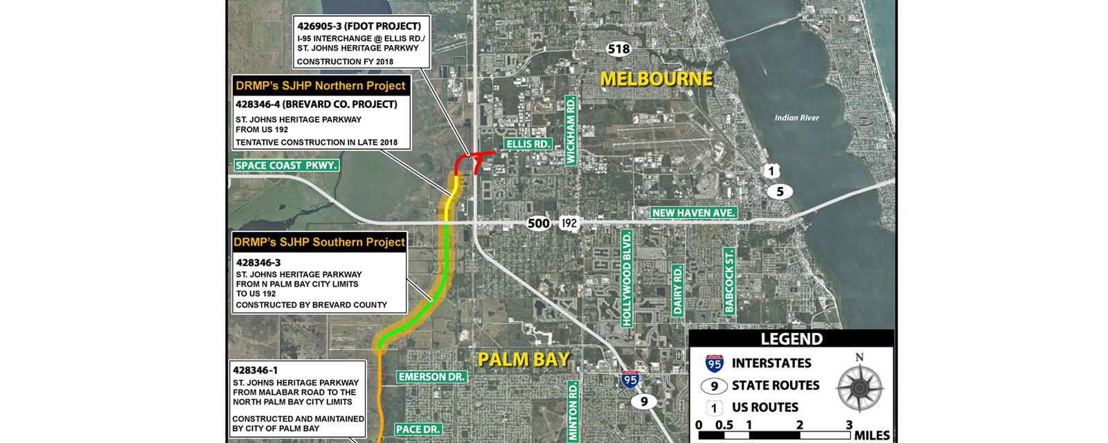
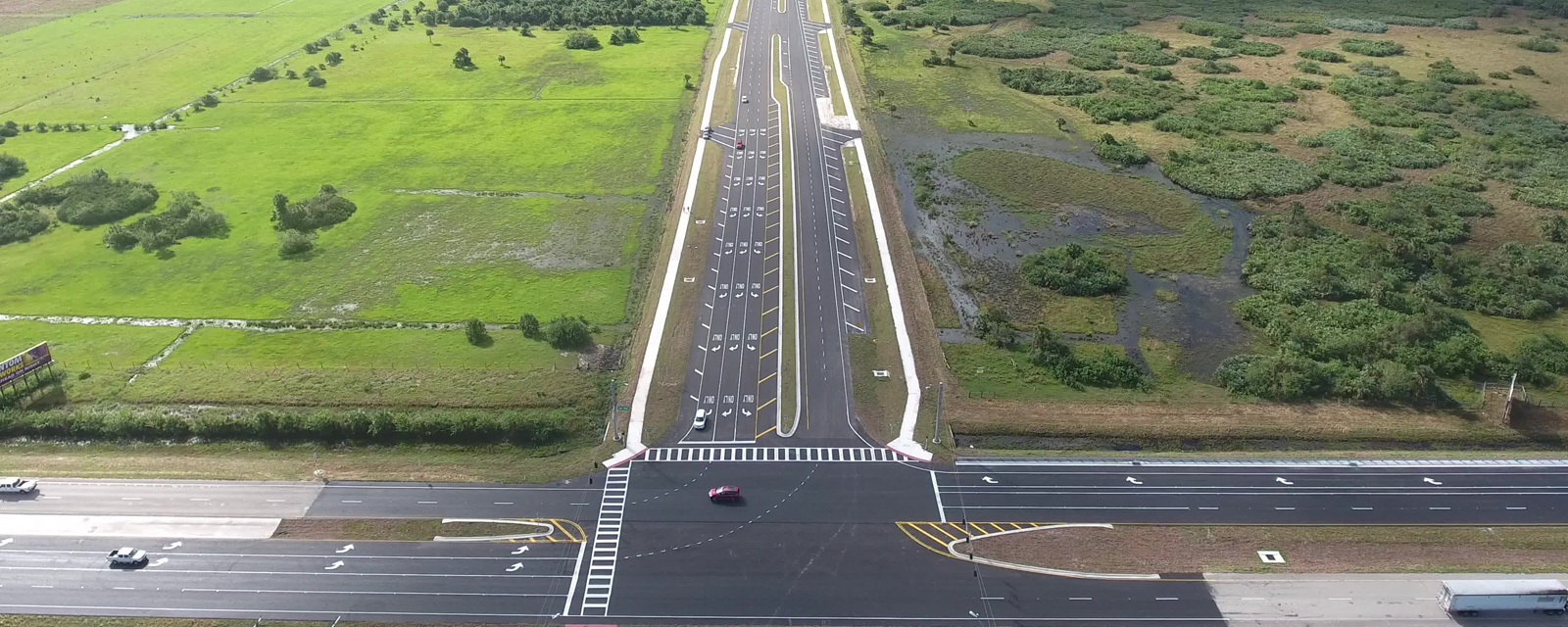
St. Johns Heritage Parkway Study
The St. Johns Heritage Parkway Study project limits were from the City of Palm Bay, to the south, to the intersection of Ellis Road / John Rodes Boulevard on the north end. Brevard County, Florida sought professional engineering services to evaluate this project corridor. Specific challenges associated with the design of this 4-lane divided rural roadway was that it traversed through 8-miles of farmland, wetlands, and environmentally sensitive areas. The project involves floodplain impact, wetland impacts, federally and State listed wildlife species and associated habitat, and potential contamination sites. The project involved intensive coordination with outside agencies including Federal Highway Administration (FHWA), FDOT District Five, City of Palm Bay, St Johns River Water Management District (SJRWMD), US Army Corps of Engineers (USACE), Florida Fish and Wildlife Conservation Commission (FWC), US Fish and Wildlife Services (USFWS), Florida State Historic Preservation Office (SHPO), Environmental Protection Agency (EPA), Florida Department of Environmental Protection (FDEP) and the Melbourne-Tillman Water Control District. The alignment required evaluation of alternatives to avoid and minimize impacts to both wetland and environmental sensitive areas. The project also had alignment evaluations associated with avoiding/reducing impacts to various properties and utilities along the project corridor. Bridge crossing were evaluated and in some cases relocated, or eliminated, based on changes to parcel access/property access to the Parkway itself. The drainage design was closely associated with both the floodplain impacts and available land that could accommodate both drainage and floodplain criteria.
This project involves the construction of 8-miles of 4-lane divided rural roadway and is initially constructed as a 2-lane facility due to the high construction costs associated with this project. This project involved major stormwater design, intersection design, roadway design, bridge design, utility coordination, right-of-way acquisition, and pedestrian features and included a PD&E reevaluation and preliminary engineering phase. The project was originally studied and a PD&E Document was prepared and approved by FDOT in December 2003. DRMP performed a PD&E reevaluation process to ensure the projects compliance to applicable State and Federal guidelines. This involved documenting the project impact status and verifying the concept design, environmental, and social impacts. DRMP was also tasked to develop a Preliminary Engineering Report that would further define the roadway alignment, right-of-way, survey, environmental impacts and property impacts.
Upon full completion, the Parkway will serve as a major north-south connector roadway between Palm Bay and Melbourne and other destinations north of US 192.
Key Facts
Location:
Florida
Client:
Brevard County
Size:
8-miles
Highlights:
- Preliminary design study
- Corridor study
- Evaluation of alternatives
- Project development and environment (PD&E) study reevaluation
- New roadway alignment
- Future traffic modeling
- Intersection layout
- Bridge design and layout
- Divided rural roadway
- Environmental survey
- Agency coordination
Services Provided:
Surveying & Mapping/Geospatial
Water Resources/Stormwater Management


