- Discover
-
Expertise
-
Alternative Delivery
- I-275 at I-4 Downtown Tampa Interchange Design-Build
- Wekiva Parkway Section 8 Interchange
- US 17/92 Interchange at SR 436
- SR 9B Extension from I-95 to US 1
- A. Max Brewer Bridge Replacement
- I-95 Widening from the Indian River/Brevard County Line to Malabar Road
- SR 528 (Beachline Expressway) at Innovation Way Interchange
- SR 570 Polk Parkway Widening from I-4 to Pace Road
- I-95 Express Lanes and Ramp Signals – Phase 3A-1
- Pollard Road Extension over Peace Creek
- I-485 Widening from I-77 to Rea Road
- Monroe Bypass/Connector Design-Build
- Construction Services
- Ecological Services
-
Federal Services
- Range of the Future Study
- US Coast Guard Air Station (Clearwater)
- Ascension Island Fire Station Renovation
- Patrick Space Force Base Water Lines Repair
- Patrick Space Force Base Living Shoreline Restoration
- P-505 Electrical Hardening and Black Start CHP at Marine Corps Air Station Beaufort
- Naval Station at Guantanamo Bay Survey Services
- Repair Phillips Parkway and Speed Limit Study
- Ascension Island Auxiliary Airfield Surveying and Mapping Services
-
Geographic Information Systems (GIS)
- Thermal Design/Comprehensive Campus LiDAR Collection
- Greater Orlando Aviation Authority (GOAA) Strategic Commerical Land Development Program
- University of Florida Sanitary Sewer GIS Mapping
- Ascension Island Auxiliary Airfield GIS Integration
- Santa Rosa County School District's School Transportation & Capacity GIS Analysis
- Gainesville Community Redevelopment Agency Socioeconomic Analysis and Site Suitability Report
- Real Estate Site Suitability and Development Analysis
- SR 836 (Dolphin Expressway) GIS Asset Inventory of Pre-Post Construction
- Alachua County Public Schools GIS and School Planning Professional Services
- Patrick Air Force Base Living Shoreline Restoration GIS Analysis
- Florida Army National Guard Readiness Center GIS Inventory & Integration
- Comprehensive Transit Study Puerto Rico GIS Analysis
- Land Development
- Structural Engineering
-
Subsurface Utility Engineering (SUE)
- Thermal Design/Comprehensive Campus LiDAR Collection
- P-505 Electrical Hardening and Black Start CHP at Marine Corps Air Station Beaufort
- Resurface & Safety Improvements Turnpike Mainline
- University of Florida Rabon Utility Mapping
- FP&L Subsurface Utility Engineering Continuing On-Call Contract
- Lockheed Martin Subsurface Utility Engineering Services
- Palm Coast Parkway Subsurface Utility Engineering Services
- Surveying & Mapping/Geospatial
-
Traffic Impact Analysis
- 505 West Chapel Hill Street
- 5th Street Station
- Beale Farm Industrial Park
- Blue Mountain Mist Resort
- The Villages at McCullers Walk
- Fredericksburg National Baseball Stadium
- Hendrick Southpoint Auto Mall
- Apex Friendship Elementary School
- Whole Foods Center
- Barclay West
- Grove 98
- Pullen Drive Extension/Catholic Diocese
- Trails/Parks & Recreation Facilities
- Transportation
-
Utilities Engineering
- Ascension Island Fire Station Renovation
- M-1 Canal Water Main Extension
- 5th Street Bridge Utility Replacement
- Captain’s Cove Wastewater Plant Revisions & Permit Renewal
- City of Fort Myers Downtown Utility & Streetscape Improvement
- Florida Caverns State Park Lift Station Rehab
- Tween Waters Inn Wastewater Plant Permit Renewal
- City of Fort Myers Wastewater Capacity Studies
- Patrick Air Force Base Water Lines Repair
- Big Lagoon Boat Ramp Wastewater System
- St. Joseph State Park Septic Tank Replacement
- WildBlue Development Wastewater Modeling
- A-1 Gator Wastewater Capacity Increase
- Visualization Services
- Water Resources/Stormwater Management
-
Alternative Delivery
- Careers
- News
- #DRMPerspective
- Team With Us
- Locations
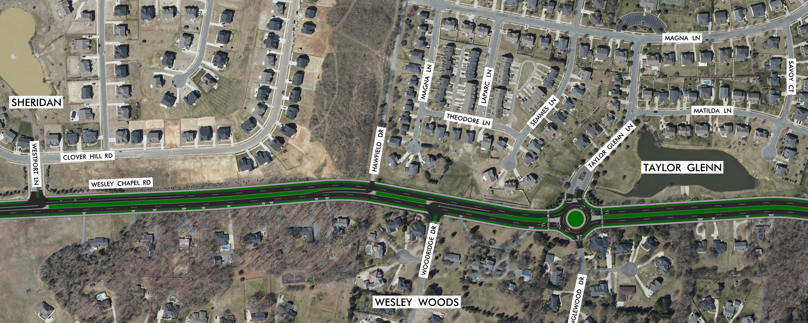
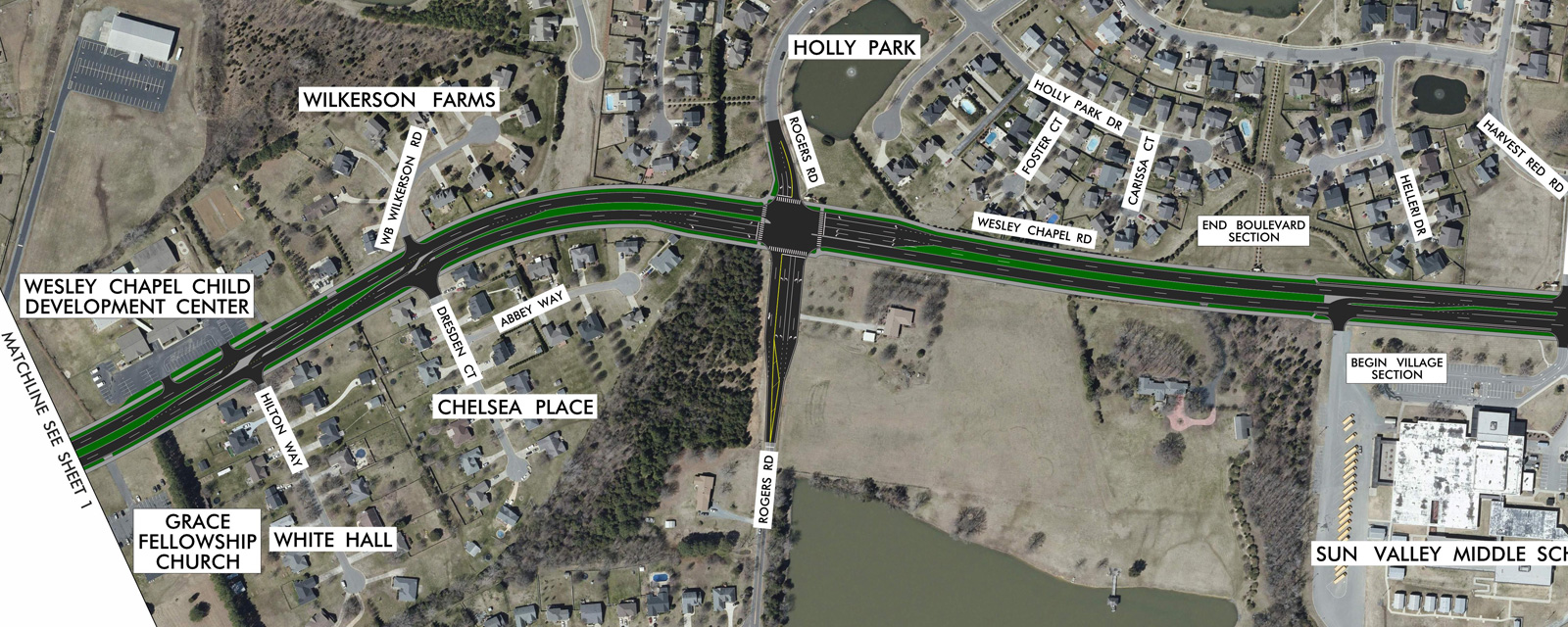
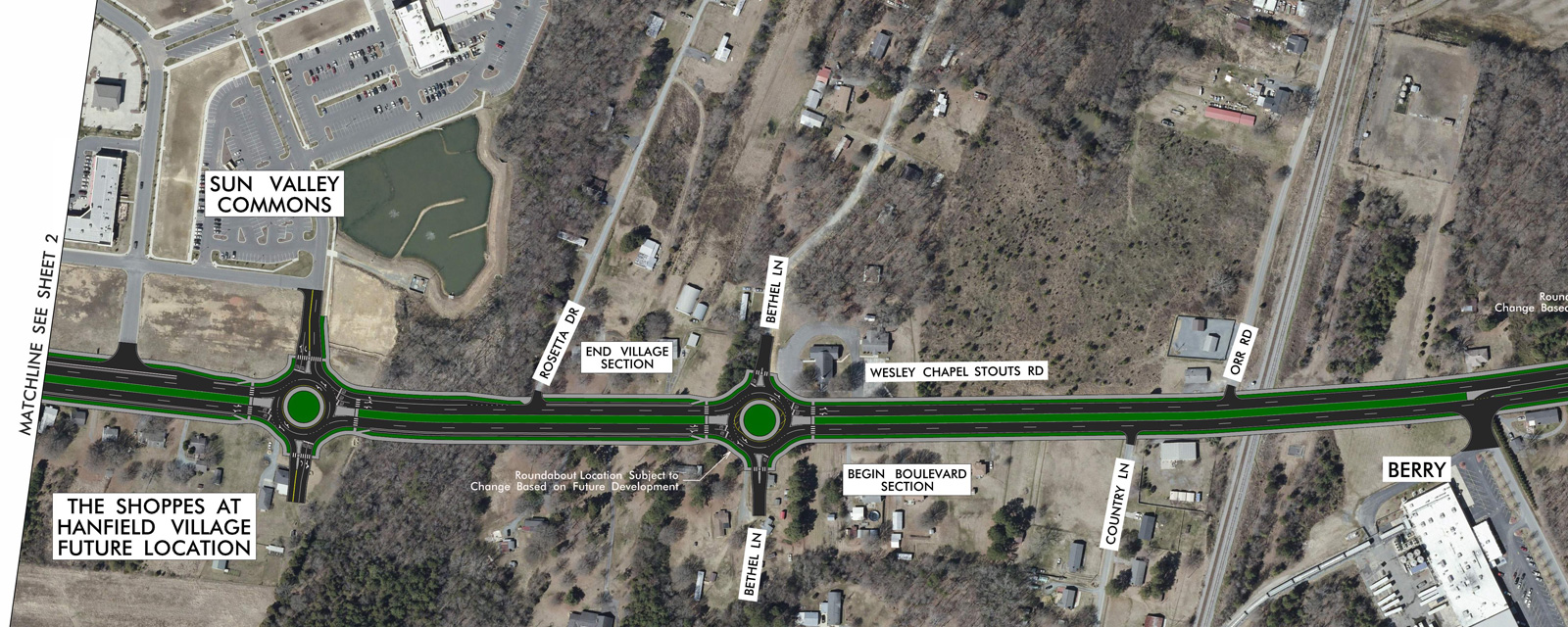
Wesley Chapel Road Corridor Study
The Wesley Chapel Road/Wesley Chapel – Stouts Road is an important roadway connector from the Sun Valley area to US 74, connecting residents, businesses, commercial and industrial users in the Town of Indian Trail, North Carolina. The objective of the Wesley Chapel Road Corridor Study is to develop a multimodal transportation plan that is complementary to the existing and future surrounding land uses while being practical and suitable for implementation by the Town of Indian Trail, North Carolina.
The Study included a total of four public participation meetings: two stakeholder advisory group meetings and two public engagement meetings. Participants provided their likes and dislikes, challenges and opportunities, as well as their vision for incorporating street elements, addressing mobility/ capacity, urban design and economic development along the Wesley Chapel Road Corridor. During the public participation meetings, stakeholders and the public were presented with two Boulevard section alternatives and two Village Center section alternatives, in addition to potential roundabouts at identified intersections. A total of five roundabouts were proposed along the Wesley Chapel Road Corridor, at the intersections of Taylor Glen Lane/Tanglewood Drive, Fulton Ridge Drive/Inlet Way, Sun Valley Commons, Bethel Lane and Archie Hargette Road.
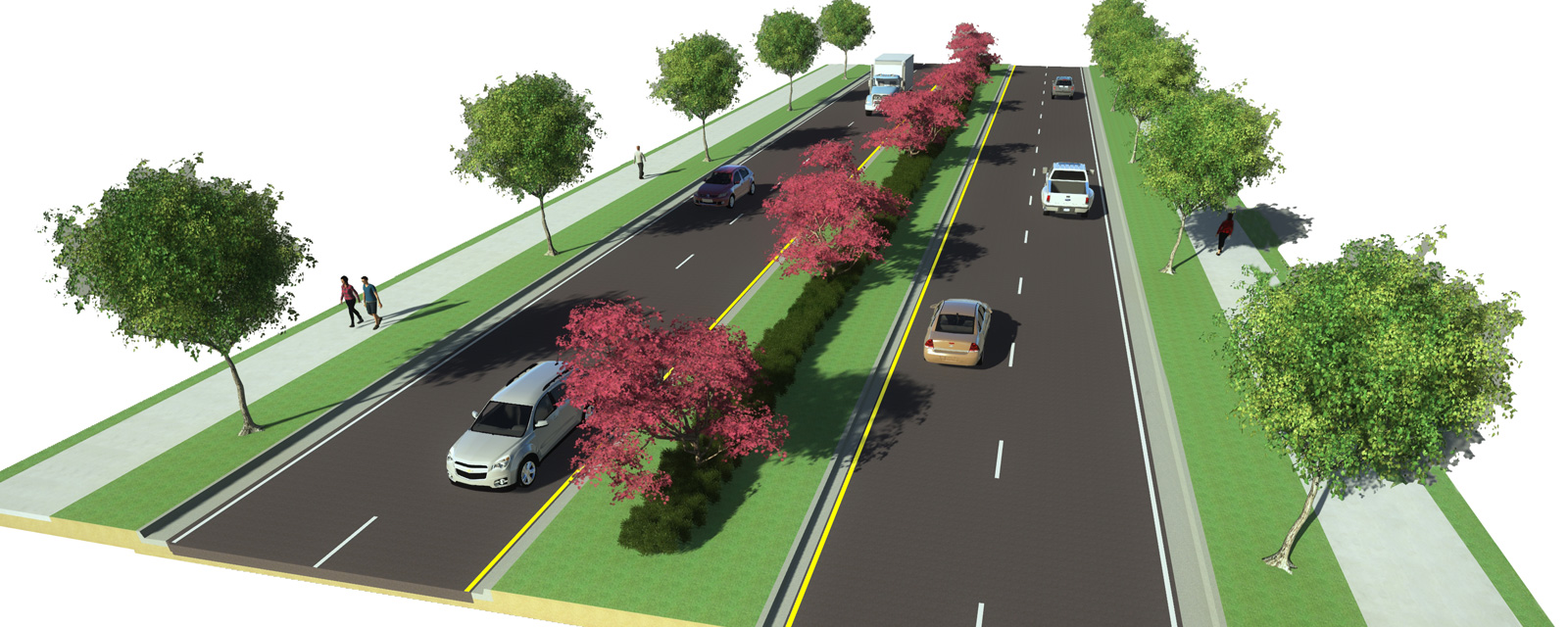
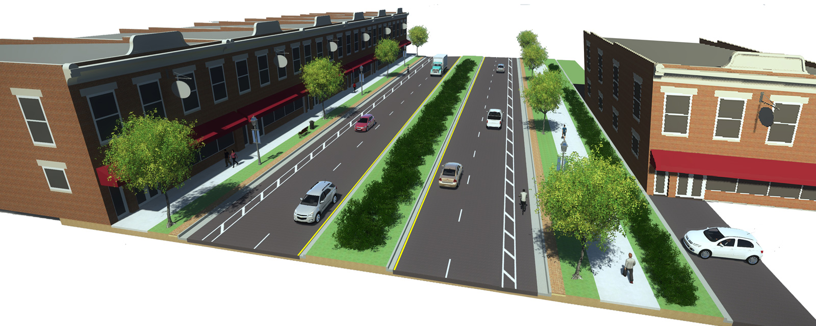
The proposed Boulevard cross section consists of four travel lanes (two lanes in each direction), a divided median, a sidewalk on one side and a multi-use path on the other side. The proposed Village Center cross section consists of four travel lanes (two lanes in each direction), a divided median, buffered bike lanes, tree zones and wide sidewalks on both sides of the roadway.
The multimodal transportation plan integrates existing and projected land use patterns with strategic transportation needs and improvements along Wesley Chapel Road to account for future growth and managing access and volumes. The overall vision for mobility and development along the corridor includes implementation strategies and performance criteria that supports the Town and community vision as well as the 2014 Town of Indian trail Comprehensive Plan.
Key Facts
Location:
North Carolina
Client:
Town of Indian Trail
Size:
3.6-miles
Highlights:
- Community engagement
- Transportation-land use plan
- Visioning
- Roundabouts
- Village center
- School
- Multi-modal
- Multi-use path
- Urban design
- Economic development
- Buffered bike lanes
Services Provided:


