- Discover
-
Expertise
-
Alternative Delivery
- I-275 at I-4 Downtown Tampa Interchange Design-Build
- Wekiva Parkway Section 8 Interchange
- US 17/92 Interchange at SR 436
- SR 9B Extension from I-95 to US 1
- A. Max Brewer Bridge Replacement
- I-95 Widening from the Indian River/Brevard County Line to Malabar Road
- SR 528 (Beachline Expressway) at Innovation Way Interchange
- SR 570 Polk Parkway Widening from I-4 to Pace Road
- I-95 Express Lanes and Ramp Signals – Phase 3A-1
- Pollard Road Extension over Peace Creek
- I-485 Widening from I-77 to Rea Road
- Monroe Bypass/Connector Design-Build
- Construction Services
- Ecological Services
-
Federal Services
- Range of the Future Study
- US Coast Guard Air Station (Clearwater)
- Ascension Island Fire Station Renovation
- Patrick Space Force Base Water Lines Repair
- Patrick Space Force Base Living Shoreline Restoration
- P-505 Electrical Hardening and Black Start CHP at Marine Corps Air Station Beaufort
- Naval Station at Guantanamo Bay Survey Services
- Repair Phillips Parkway and Speed Limit Study
- Ascension Island Auxiliary Airfield Surveying and Mapping Services
-
Geographic Information Systems (GIS)
- Thermal Design/Comprehensive Campus LiDAR Collection
- Greater Orlando Aviation Authority (GOAA) Strategic Commerical Land Development Program
- University of Florida Sanitary Sewer GIS Mapping
- Ascension Island Auxiliary Airfield GIS Integration
- Santa Rosa County School District's School Transportation & Capacity GIS Analysis
- Gainesville Community Redevelopment Agency Socioeconomic Analysis and Site Suitability Report
- Real Estate Site Suitability and Development Analysis
- SR 836 (Dolphin Expressway) GIS Asset Inventory of Pre-Post Construction
- Alachua County Public Schools GIS and School Planning Professional Services
- Patrick Air Force Base Living Shoreline Restoration GIS Analysis
- Florida Army National Guard Readiness Center GIS Inventory & Integration
- Comprehensive Transit Study Puerto Rico GIS Analysis
- Land Development
- Structural Engineering
-
Subsurface Utility Engineering (SUE)
- Thermal Design/Comprehensive Campus LiDAR Collection
- P-505 Electrical Hardening and Black Start CHP at Marine Corps Air Station Beaufort
- Resurface & Safety Improvements Turnpike Mainline
- University of Florida Rabon Utility Mapping
- FP&L Subsurface Utility Engineering Continuing On-Call Contract
- Lockheed Martin Subsurface Utility Engineering Services
- Palm Coast Parkway Subsurface Utility Engineering Services
- Surveying & Mapping/Geospatial
-
Traffic Impact Analysis
- 505 West Chapel Hill Street
- 5th Street Station
- Beale Farm Industrial Park
- Blue Mountain Mist Resort
- The Villages at McCullers Walk
- Fredericksburg National Baseball Stadium
- Hendrick Southpoint Auto Mall
- Apex Friendship Elementary School
- Whole Foods Center
- Barclay West
- Grove 98
- Pullen Drive Extension/Catholic Diocese
- Trails/Parks & Recreation Facilities
- Transportation
-
Utilities Engineering
- Ascension Island Fire Station Renovation
- M-1 Canal Water Main Extension
- 5th Street Bridge Utility Replacement
- Captain’s Cove Wastewater Plant Revisions & Permit Renewal
- City of Fort Myers Downtown Utility & Streetscape Improvement
- Florida Caverns State Park Lift Station Rehab
- Tween Waters Inn Wastewater Plant Permit Renewal
- City of Fort Myers Wastewater Capacity Studies
- Patrick Air Force Base Water Lines Repair
- Big Lagoon Boat Ramp Wastewater System
- St. Joseph State Park Septic Tank Replacement
- WildBlue Development Wastewater Modeling
- A-1 Gator Wastewater Capacity Increase
- Visualization Services
- Water Resources/Stormwater Management
-
Alternative Delivery
- Careers
- News
- #DRMPerspective
- Team With Us
- Locations

DRMP Uses UAV Technology to Survey and Reduce Damage in NC Landslides
July 15th, 2020


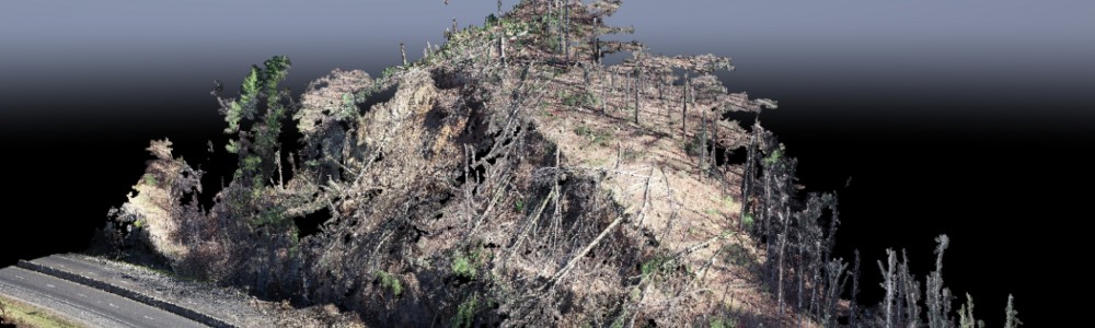
On Friday, February 22, 2019, a landslide occurred, dumping approximately 4-million gallons of rock and soil on Interstate 40, a major highway in the western part of North Carolina. The landslide shut down westbound I-40 and an eastbound exit just before midnight. Working as a subconsultant to S&ME, Inc. on a North Carolina Department of Transportation (NCDOT) project, our mission was to help get the highway open to keep traffic moving.
Within 10-hours of the landslide, DRMP surveyors were mobilized and, on the site, prepared to launch our unmanned aerial vehicle (UAV) to start collecting data for NCDOT to aid in their planning to get this major highway that stretches between North Carolina and Tennessee open.
By using specialized UAV equipment, along with our several years of surveying expertise was key. My team set ground control and flew several UAV missions to create surface models to help ensure the area was safe for the public. The surface models allow the NCDOT to see what the landslide consisted of to develop their plan of action. Without surface models, voids and hazards might have been missed. It’s a known fact that landslides are common to this area and are volatile and likely to happen again. To mitigate future damage, my team went back to the site of the landslide days and weeks later to perform more UAV missions and surveys of the area. My team and I feel the surveying services we provided really helped speed up the recovery process.
This isn’t the first time, we’ve helped gather data with UAVs for landslides in North Carolina. In addition to the I-40 landslide, we assisted with two other landslides in western North Carolina, the Buffalo Creek Road and Gerton Highway landslides that happened just southeast of Asheville, North Carolina. Our team is ready to mobilize at a moment’s notice when a landslide occurs, but we also have the expertise to provide data that helps mitigate future data in recurring landslides.
After the Buffalo Creek Road landslide in January 2019, a few months before the I-40 slide, DRMP set monitoring points and aerial targets to inspect ground movement near Bald Mountain Lake at the surface. After setting and surveying the points, we flew UAV missions on four separate occasions and provided 3D models of the area. This confirmed a movement problem that needed to be addressed.
Our team flew a UAV mission to support a volume study for the Gerton Highway landslide which also occurred in January 2019. The study was for the excavation of volatile areas on the highway. We provided a 3D model to be used to design a “V”-shaped slope with a catchment in the center to direct future falls away from traffic. This helped the NCDOT get ahead of the major damage another landslide could cause.
With our growing experience in mobilizing support and the latest technology for real-time and future landslides, my team and I are becoming an asset to be used in helping the region avoid and lessen hazards due to recurring landslides. It’s gratifying for me and my team to perform a service where we can see the relief it provides to our community.
August Thick II, PLS, is a Survey Project Manager in DRMP's Charlotte, NC, office and is certified by the FAA as a Unmanned Aerial System commercial pilot. .
Share This Page![]()


Categories
- All
- Featured Posts
- Alternative Delivery
- Construction Services
- Ecological Services
- Geographic Information Systems
- Land Development
- Structural Engineering
- Subsurface Utility Engineering
- Surveying & Mapping
- Transportation
- Water Resources/Stormwater Management
- Federal Services
- Project Development & Environment
- NEPA
- Transportation Planning/Project Development
- Utilities Engineering
Contributors
- Michael K. Albano, PE
- Bruno J. Arriola, PE, ENV SP
- Martha Ayers
- Brent Bass, PE, PSM
- Cody Bayer, PE
- Donald W. Brown, PE
- Kyle Brown, PE
- Michael Bywaletz, PE, CPESC, ENV SP
- Zach J. Carnahan, PE
- Brian Crowl, PE
- Patrick Day, PE
- Nick DeVito, PE
- Matt Floyd, PSM
- Deshon M. Fox, PE
- Scott Garth, PE, LEED AP ND
- Ryan M. Grab, CST II
- Robyn Hartz
- TJ Lallathin, Jr., PE, DBIA
- Kelly Marton, GISP
- Meaghan McCarthy
- George McLatchey, PWS, CEP
- Shawn McLemore, PE
- Jeff Miller
- Ryan Mitchell, PE
- Lisa Moon, PE
- Megan E. Mott, PE
- Josh Norman
- Julian Poole, PE
- Mark Prochak, PE
- Abby Rains
- Leo Rodriguez, PE
- Kimberly Santiago-Ortiz, PE
- Rachel L. Schmidt, PWS
- Logan Shappell
- Brian V. Smith
- Rynal Stephenson, PE
- Deston Taylor, EI
- August Thick, PLS
- Ron Wallace, PE
- Steven L. Wallace, PE
- Orville Williams
- Amanda E. Woods, PE


