- Discover
-
Expertise
-
Alternative Delivery
- I-275 at I-4 Downtown Tampa Interchange Design-Build
- Wekiva Parkway Section 8 Interchange
- US 17/92 Interchange at SR 436
- SR 9B Extension from I-95 to US 1
- A. Max Brewer Bridge Replacement
- I-95 Widening from the Indian River/Brevard County Line to Malabar Road
- SR 528 (Beachline Expressway) at Innovation Way Interchange
- SR 570 Polk Parkway Widening from I-4 to Pace Road
- I-95 Express Lanes and Ramp Signals – Phase 3A-1
- Pollard Road Extension over Peace Creek
- I-485 Widening from I-77 to Rea Road
- Monroe Bypass/Connector Design-Build
- Construction Services
- Ecological Services
-
Federal Services
- Range of the Future Study
- US Coast Guard Air Station (Clearwater)
- Ascension Island Fire Station Renovation
- Patrick Space Force Base Water Lines Repair
- Patrick Space Force Base Living Shoreline Restoration
- P-505 Electrical Hardening and Black Start CHP at Marine Corps Air Station Beaufort
- Naval Station at Guantanamo Bay Survey Services
- Repair Phillips Parkway and Speed Limit Study
- Ascension Island Auxiliary Airfield Surveying and Mapping Services
-
Geographic Information Systems (GIS)
- Thermal Design/Comprehensive Campus LiDAR Collection
- Greater Orlando Aviation Authority (GOAA) Strategic Commerical Land Development Program
- University of Florida Sanitary Sewer GIS Mapping
- Ascension Island Auxiliary Airfield GIS Integration
- Santa Rosa County School District's School Transportation & Capacity GIS Analysis
- Gainesville Community Redevelopment Agency Socioeconomic Analysis and Site Suitability Report
- Real Estate Site Suitability and Development Analysis
- SR 836 (Dolphin Expressway) GIS Asset Inventory of Pre-Post Construction
- Alachua County Public Schools GIS and School Planning Professional Services
- Patrick Air Force Base Living Shoreline Restoration GIS Analysis
- Florida Army National Guard Readiness Center GIS Inventory & Integration
- Comprehensive Transit Study Puerto Rico GIS Analysis
- Land Development
- Structural Engineering
-
Subsurface Utility Engineering (SUE)
- Thermal Design/Comprehensive Campus LiDAR Collection
- P-505 Electrical Hardening and Black Start CHP at Marine Corps Air Station Beaufort
- Resurface & Safety Improvements Turnpike Mainline
- University of Florida Rabon Utility Mapping
- FP&L Subsurface Utility Engineering Continuing On-Call Contract
- Lockheed Martin Subsurface Utility Engineering Services
- Palm Coast Parkway Subsurface Utility Engineering Services
- Surveying & Mapping/Geospatial
-
Traffic Impact Analysis
- 505 West Chapel Hill Street
- 5th Street Station
- Beale Farm Industrial Park
- Blue Mountain Mist Resort
- The Villages at McCullers Walk
- Fredericksburg National Baseball Stadium
- Hendrick Southpoint Auto Mall
- Apex Friendship Elementary School
- Whole Foods Center
- Barclay West
- Grove 98
- Pullen Drive Extension/Catholic Diocese
- Trails/Parks & Recreation Facilities
- Transportation
-
Utilities Engineering
- Ascension Island Fire Station Renovation
- M-1 Canal Water Main Extension
- 5th Street Bridge Utility Replacement
- Captain’s Cove Wastewater Plant Revisions & Permit Renewal
- City of Fort Myers Downtown Utility & Streetscape Improvement
- Florida Caverns State Park Lift Station Rehab
- Tween Waters Inn Wastewater Plant Permit Renewal
- City of Fort Myers Wastewater Capacity Studies
- Patrick Air Force Base Water Lines Repair
- Big Lagoon Boat Ramp Wastewater System
- St. Joseph State Park Septic Tank Replacement
- WildBlue Development Wastewater Modeling
- A-1 Gator Wastewater Capacity Increase
- Visualization Services
- Water Resources/Stormwater Management
-
Alternative Delivery
- Careers
- News
- #DRMPerspective
- Team With Us
- Locations

DRMP Teams Up with the University of Central Florida to Study Wildlife Crossings
February 9th, 2023


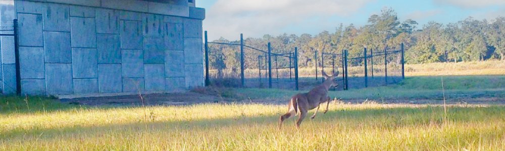
Highways are known to have ecological effects on various species of wildlife and their habitats. These effects include loss and fragmentation of wildlife habitat, increased mortality of species attempting to cross highway corridors, and the creation of barriers to wildlife movements and dispersal.
The presence of wildlife on roads can also pose safety hazards for motorists. Wildlife crossings are often proposed as the solution to these problems during the planning phases of projects involving construction of new highways or improvements to existing roads.
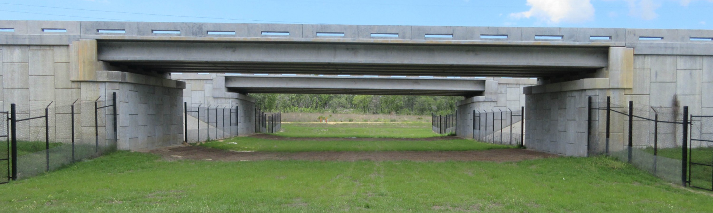
This was the case for the Florida’s Turnpike Enterprise (FTE) Suncoast Parkway 2 project, an approximately 26-mile, divided limited-access toll facility designed to increase capacity and ease traffic congestion in Hernando and Citrus counties in Florida.
FTE contracted DRMP to design and permit the construction of a wildlife crossing and smaller crossings along the corridor connecting the state lands on either side of the Suncoast Parkway 2 alignment. DRMP will conduct pre- and post-construction studies to evaluate the effectiveness of the crossings.
Strategic Location
Several factors were evaluated in determining the location of this wildlife crossing, including: the presence of public lands, vegetative cover, topography, and structural design.
The type of wildlife crossing that is constructed is a function of the species to be accommodated and highway design standards pertaining to safety, slope, and topography.
.png?v=1675967719893)
One of the essential elements in determining the location of a wildlife crossing was the presence of suitable habitat on either side of the crossing and the need for that land to be protected and managed in perpetuity. Should one side of the crossing be developed, the need for wildlife to cross at that location could be significantly reduced, or potentially render the structure useless. For this reason, FTE chose to locate the crossing between the publicly owned lands of the Annuntteliga Hammock tract of the Withlacoochee State Forest and the Chassahowitzka Wildlife Management Area, along the Suncoast Parkway 2 alignment.
Crossings also work more effectively with highway fencing, strategically placed on one or both sides of the entrance to direct wildlife toward the crossing.
This has been an interesting project so far, and it will be fascinating to see if our wildlife crossings will continue to do what they are intended to do – significantly reduce the number of animal-related vehicle collisions and provide safe connectivity for wildlife and people.
The Study
DRMP’s Environmental Services Division has partnered with Daniel J. Smith, Ph.D., a research scientist at the University of Central Florida’s (UCF) Department of Biology, to conduct an 11-month wildlife utilization study to assess the effectiveness of the Suncoast Parkway 2 wildlife crossing structure that began in August 2022.
This type of study uses treatment and control sites to fully evaluate the use and effectiveness of the constructed wildlife crossing. Treatment sites include the location of the constructed wildlife crossings and one site along the alignment where a wildlife crossing was not proposed. Control sites evaluate effects at a distance of at least 500 meters from the highway and crossings.
This plan comprises a stratified block design of nine total study sites that evaluate impacts on both sides of the highway. Using this approach, we plan to identify the diversity and abundance of species that presently occur within and adjacent to the constructed alignment.
Based on the key focal species identified by the Florida Fish and Wildlife Conservation Commission (FWC), the primary focus of our evaluation is on select groups of mammals and herptiles, including the Florida Black Bear. We are using various methods to identify presence or absence of species using techniques that include capture-mark-recapture, track surveys, and camera traps. A description of proposed field techniques includes:
- Herp/small mammal trap arrays set up in three replicates that include three arrays each on the right-of-way at each of the two constructed wildlife crossings and one control site and at a minimum of 500 meters distance from each side of the road alignment
- Large snake surveys will be performed using large box traps and tortoise burrow inspections
- Track/scat surveys will be performed at each wildlife crossing and on select sections of forest roads, trails, and the powerline corridor for medium-large mammals
- Camera traps will be used at each wildlife crossing and on select sections of forest roads, trails, and the powerline corridor for medium-large mammals and turkey
Monitoring of this wildlife crossing will ultimately provide management with sound data for planning and design of future crossings. Properly designed and located wildlife crossings will decrease road-related mortality and increase in the frequency of highway crossings by focal species. Properly designed monitoring programs will assist with evaluating the effectiveness of the crossing and lead to a better understanding for the placement and types of wildlife crossing structures.
George McLatchey, PWS, CEP, is a DRMP Vice President and Environmental Services Division Manager.
Posted in the categories All, Ecological Services.

Categories
- All
- Featured Posts
- Alternative Delivery
- Construction Services
- Ecological Services
- Geographic Information Systems
- Land Development
- Structural Engineering
- Subsurface Utility Engineering
- Surveying & Mapping
- Transportation
- Water Resources/Stormwater Management
- Federal Services
- Project Development & Environment
- NEPA
- Transportation Planning/Project Development
- Utilities Engineering
Contributors
- Michael K. Albano, PE
- Bruno J. Arriola, PE, ENV SP
- Martha Ayers
- Brent Bass, PE, PSM
- Cody Bayer, PE
- Donald W. Brown, PE
- Kyle Brown, PE
- Michael Bywaletz, PE, CPESC, ENV SP
- Zach J. Carnahan, PE
- Brian Crowl, PE
- Patrick Day, PE
- Nick DeVito, PE
- Matt Floyd, PSM
- Deshon M. Fox, PE
- Scott Garth, PE, LEED AP ND
- Ryan M. Grab, CST II
- Robyn Hartz
- TJ Lallathin, Jr., PE, DBIA
- Kelly Marton, GISP
- Meaghan McCarthy
- George McLatchey, PWS, CEP
- Shawn McLemore, PE
- Jeff Miller
- Ryan Mitchell, PE
- Lisa Moon, PE
- Megan E. Mott, PE
- Josh Norman
- Julian Poole, PE
- Mark Prochak, PE
- Abby Rains
- Leo Rodriguez, PE
- Kimberly Santiago-Ortiz, PE
- Rachel L. Schmidt, PWS
- Logan Shappell
- Brian V. Smith
- Rynal Stephenson, PE
- Deston Taylor, EI
- August Thick, PLS
- Ron Wallace, PE
- Steven L. Wallace, PE
- Orville Williams
- Amanda E. Woods, PE


