- Discover
-
Expertise
-
Alternative Delivery
- I-275 at I-4 Downtown Tampa Interchange Design-Build
- Wekiva Parkway Section 8 Interchange
- US 17/92 Interchange at SR 436
- SR 9B Extension from I-95 to US 1
- A. Max Brewer Bridge Replacement
- I-95 Widening from the Indian River/Brevard County Line to Malabar Road
- SR 528 (Beachline Expressway) at Innovation Way Interchange
- SR 570 Polk Parkway Widening from I-4 to Pace Road
- I-95 Express Lanes and Ramp Signals – Phase 3A-1
- Pollard Road Extension over Peace Creek
- I-485 Widening from I-77 to Rea Road
- Monroe Bypass/Connector Design-Build
- Construction Services
- Ecological Services
-
Federal Services
- Range of the Future Study
- US Coast Guard Air Station (Clearwater)
- Ascension Island Fire Station Renovation
- Patrick Space Force Base Water Lines Repair
- Patrick Space Force Base Living Shoreline Restoration
- P-505 Electrical Hardening and Black Start CHP at Marine Corps Air Station Beaufort
- Naval Station at Guantanamo Bay Survey Services
- Repair Phillips Parkway and Speed Limit Study
- Ascension Island Auxiliary Airfield Surveying and Mapping Services
-
Geographic Information Systems (GIS)
- Thermal Design/Comprehensive Campus LiDAR Collection
- Greater Orlando Aviation Authority (GOAA) Strategic Commerical Land Development Program
- University of Florida Sanitary Sewer GIS Mapping
- Ascension Island Auxiliary Airfield GIS Integration
- Santa Rosa County School District's School Transportation & Capacity GIS Analysis
- Gainesville Community Redevelopment Agency Socioeconomic Analysis and Site Suitability Report
- Real Estate Site Suitability and Development Analysis
- SR 836 (Dolphin Expressway) GIS Asset Inventory of Pre-Post Construction
- Alachua County Public Schools GIS and School Planning Professional Services
- Patrick Air Force Base Living Shoreline Restoration GIS Analysis
- Florida Army National Guard Readiness Center GIS Inventory & Integration
- Comprehensive Transit Study Puerto Rico GIS Analysis
- Land Development
- Structural Engineering
-
Subsurface Utility Engineering (SUE)
- Thermal Design/Comprehensive Campus LiDAR Collection
- P-505 Electrical Hardening and Black Start CHP at Marine Corps Air Station Beaufort
- Resurface & Safety Improvements Turnpike Mainline
- University of Florida Rabon Utility Mapping
- FP&L Subsurface Utility Engineering Continuing On-Call Contract
- Lockheed Martin Subsurface Utility Engineering Services
- Palm Coast Parkway Subsurface Utility Engineering Services
- Surveying & Mapping/Geospatial
-
Traffic Impact Analysis
- 505 West Chapel Hill Street
- 5th Street Station
- Beale Farm Industrial Park
- Blue Mountain Mist Resort
- The Villages at McCullers Walk
- Fredericksburg National Baseball Stadium
- Hendrick Southpoint Auto Mall
- Apex Friendship Elementary School
- Whole Foods Center
- Barclay West
- Grove 98
- Pullen Drive Extension/Catholic Diocese
- Trails/Parks & Recreation Facilities
- Transportation
-
Utilities Engineering
- Ascension Island Fire Station Renovation
- M-1 Canal Water Main Extension
- 5th Street Bridge Utility Replacement
- Captain’s Cove Wastewater Plant Revisions & Permit Renewal
- City of Fort Myers Downtown Utility & Streetscape Improvement
- Florida Caverns State Park Lift Station Rehab
- Tween Waters Inn Wastewater Plant Permit Renewal
- City of Fort Myers Wastewater Capacity Studies
- Patrick Air Force Base Water Lines Repair
- Big Lagoon Boat Ramp Wastewater System
- St. Joseph State Park Septic Tank Replacement
- WildBlue Development Wastewater Modeling
- A-1 Gator Wastewater Capacity Increase
- Visualization Services
- Water Resources/Stormwater Management
-
Alternative Delivery
- Careers
- News
- #DRMPerspective
- Team With Us
- Locations

DRMP's Design Approach Transforms Angelica-Osage Roadway into a Community Connector
March 13th, 2024


To innovative engineers, roadways are much more than pathways that take us from point A to B. They are integral parts of our environmental and social ecosystems that allow modern societies to function as connected communities.
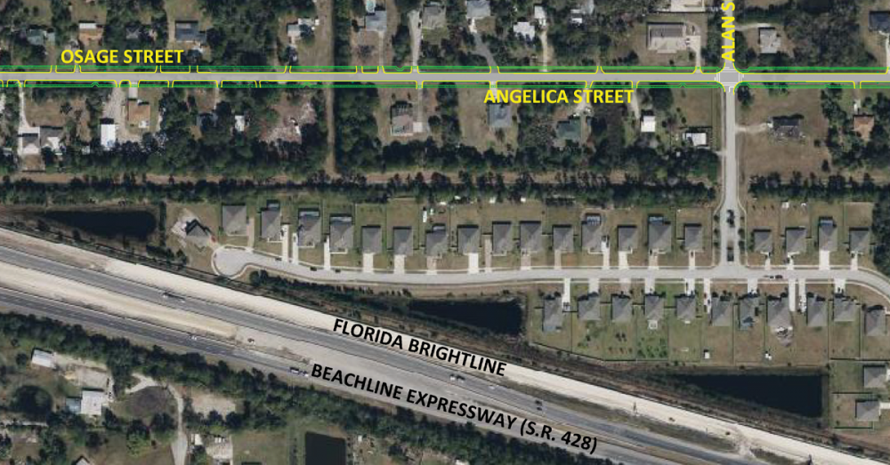
Let us look at the Angelica-Osage roadway improvement project in Brevard County, Fla., currently under design by DRMP. At first glance, the project is another typical roadway improvement venture: new asphalt roads with adjacent swales and sidewalks. A closer look at the project reveals an opportunity to improve a 1-mile rural stretch of County-owned public Right of Way (ROW) in an environmentally responsible manner.
The Angelica-Osage continuous corridor will act as the only access road connecting a new planned residential community to Grissom Parkway. Consequently, improving this corridor is essential to handle the expected increase in traffic and pedestrian activity.
This limited ROW—bounded on the north and south by residential lots with some built houses—must accommodate the proposed asphalt roadway, engineered treatment swales, and sidewalks on both sides of the two-lane road.
The project will increase adjacent property values and manage stormwater in the area, while serving as a safe gateway to a newly planned residential community in the initial stages of development at the west end of the corridor.
More importantly, the new road, once built, will provide the planned community to the west and the existing residential lots adjacent to the ROW with an amenity for outdoor activity, such as walking for exercise and dog walking.
Sophisticated Design Approaches
The task before the DRMP design team seemed straightforward; however, the existing condition of the corridor posed challenges requiring sophisticated design approaches.
The project area consists of two contiguous partially paved dirt roads crossed intermittently by water-filled ditches, bounded by overgrown organically shaped swales and single-family lots. DRMP’s design team approached the project by allocating segments of the design to team members with specialized expertise in particular areas.
Using survey topographic data provided by DRMP’s surveyors and geotechnical data provided by a sub-consultant, the lead drainage designer used the Advanced Interconnected Pond Routing (adICPR) stormwater software to model hydrologic and hydraulic pre-and-post construction conditions of the drainage basin.
The model established several fundamental parameters of the design, including roadway elevations, swale dimensions, control structure locations, drainage pipe alignments, ditch block locations, and the dimensions of a dry detention pond.
A second drainage engineer performed a secondary analysis of the drainage pipes throughout the system. They used stormwater flow volumes generated by the post condition adICPR model. The goal was to ensure adequate pipe sizes are specified, which would provide adequate stormwater storage and flow rates to predetermined outfall zones. It aims to prevent flooding of roads or adjacent properties during a 100-year, 24-hour storm event.
Additionally, AutoCAD Civil 3D, a powerful software commonly used by civil engineers, was used to generate pre- and post-condition surface elevations across the width of the ROW, allowing dynamic cross-sections to be generated at any point along the ROW alignment. The dynamic nature of the cross-sections means that the cross-sections update automatically with any grade changes to the proposed surface, saving valuable time during the iterative design process.
Project Turnaround
The Angelica-Osage road improvement civil engineering designs are ongoing. Sixty percent design plans have been completed and provided to the Client and County for a progress review. Internal quality control reviews are being conducted, as per detailed protocols established by our Orlando-based civil engineering team at DRMP, to ensure the final design deliverables represent best engineering practices and adherence to relevant design guidelines of the County, City, and St. John’s Water Management District.
The design effort to take the plans to 100 percent completion will include fine-tuning of the adICPR model and the secondary analysis calculations, checks of proposed ground elevations, and stormwater pipes to avoid conflicts with proposed underground utility upgrades along the ROW (DRMP recently secured construction approval for utility upgrades along the same corridor) and further coordination with review agencies.
The end result, after more than six months of collaborative design effort, will be construction plans for a two-lane, professionally designed roadway that represents a significant enhancement of the existing, rural road. As such, the new roadway will become more than a path for vehicles to move from point A to B, but a durable feature of the community that symbolizes social connectivity and progress within the built environment.

Deshon M. Fox, PE, is DRMP's Central Florida Department Manager for General Civil Municipal Market Sector
Posted in the category All.

Categories
- All
- Featured Posts
- Alternative Delivery
- Construction Services
- Ecological Services
- Geographic Information Systems
- Land Development
- Structural Engineering
- Subsurface Utility Engineering
- Surveying & Mapping
- Transportation
- Water Resources/Stormwater Management
- Federal Services
- Project Development & Environment
- NEPA
- Transportation Planning/Project Development
- Utilities Engineering
Contributors
- Michael K. Albano, PE
- Bruno J. Arriola, PE, ENV SP
- Martha Ayers
- Brent Bass, PE, PSM
- Cody Bayer, PE
- Donald W. Brown, PE
- Kyle Brown, PE
- Michael Bywaletz, PE, CPESC, ENV SP
- Zach J. Carnahan, PE
- Brian Crowl, PE
- Patrick Day, PE
- Nick DeVito, PE
- Matt Floyd, PSM
- Deshon M. Fox, PE
- Scott Garth, PE, LEED AP ND
- Ryan M. Grab, CST II
- Robyn Hartz
- TJ Lallathin, Jr., PE, DBIA
- Kelly Marton, GISP
- Meaghan McCarthy
- George McLatchey, PWS, CEP
- Shawn McLemore, PE
- Jeff Miller
- Ryan Mitchell, PE
- Lisa Moon, PE
- Megan E. Mott, PE
- Josh Norman
- Julian Poole, PE
- Mark Prochak, PE
- Abby Rains
- Leo Rodriguez, PE
- Kimberly Santiago-Ortiz, PE
- Rachel L. Schmidt, PWS
- Logan Shappell
- Brian V. Smith
- Rynal Stephenson, PE
- Deston Taylor, EI
- August Thick, PLS
- Ron Wallace, PE
- Steven L. Wallace, PE
- Orville Williams
- Amanda E. Woods, PE


