There is so much more to the Titusville Causeway (Causeway) shoreline than meets the eye. Stretching along the Central Indian River Lagoon (Lagoon), the area is and was not only known for recreation for residents and tourists, but it has a special place in history as a viewing site for space shuttle launches dating back to the American Space Race in the 1960s.
Over the years, the now weatherworn Causeway shoreline shows erosion and destabilization caused by frequent and significant south wind driven by wave energy. Couple that with large storm events over time, including Hurricane Irma in 2017 that caused not only erosion and destabilization but caused a nearby roadway to be nearly washed away. It was past time to properly restore the Titusville Causeway Shoreline.
.jpg?v=1643831917078)
Over the years, the now weatherworn Causeway shoreline shows erosion and destabilization caused by frequent and significant south wind driven by wave energy.
Chad Rischar, PWS, and Ryan Mitchell, PE, serve as the Project Manager and Engineer of Record, respectively. Collaboration between our disciplines was key in this project to stay informed and to use each other’s expertise to help move this coastal resiliency project forward.
If the shoreline was going to live up to its legacy, we knew we had to have a layered line of defense in our design methodology against the strong winds, hurricanes, and storms causing continued damage using innovation as well as traditional environmental practices. We both agree that this is one of the most innovative projects we have ever worked on.
First Line of Defense: Wave Attenuation Devices
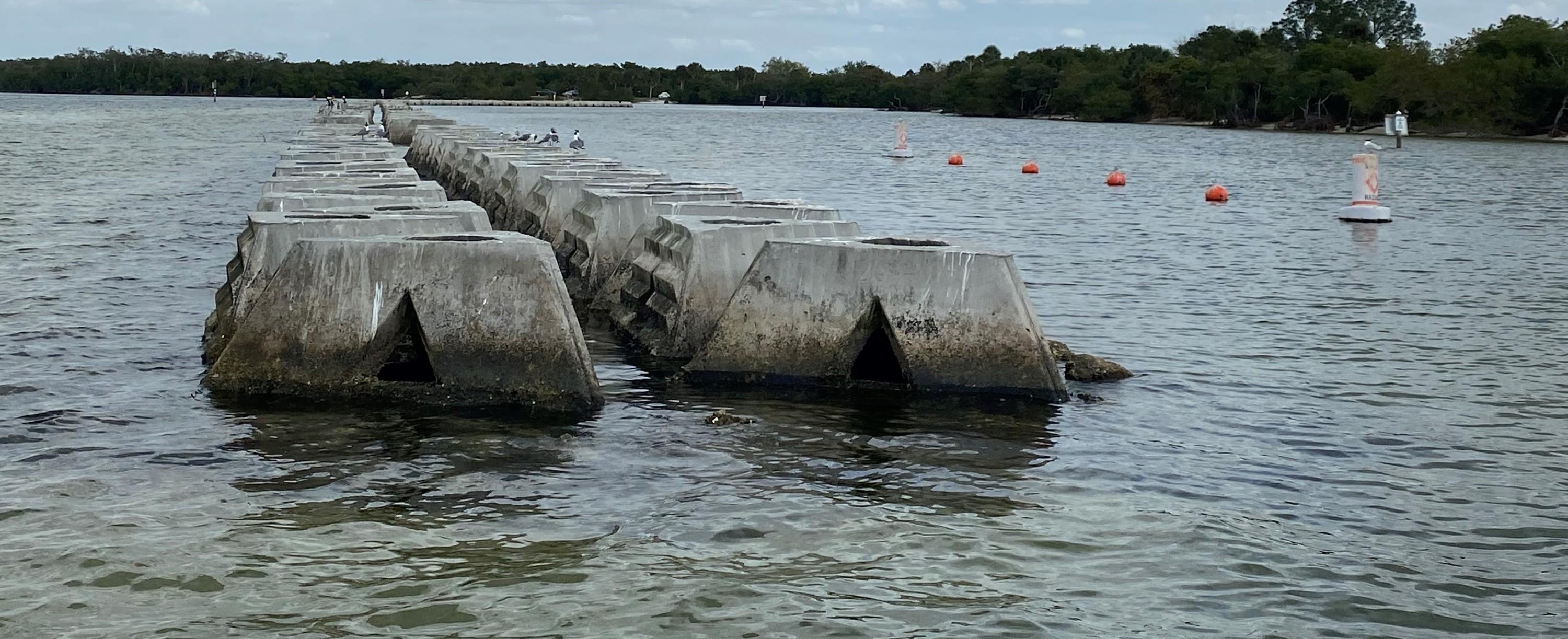
The Wave Attenuation Devices, pictured, proved to be the innovation and horsepower we needed to protect the causeway’s shoreline.
DRMP was introduced to our partner Living Shoreline Solutions in 2018 and began evaluating Wave Attenuation Devices (WADs) in 2019 to complement shoreline restoration projects. After several meetings and site visits to current projects that included WADs in the design and construction, a decision was made to include WADs as the nearshore breakwater reef for the Titusville Causeway project.
It was exciting to be on the team to introduce the use of wave attenuation technology, WADs, to Florida’s East Coast.
The WADs have been used successfully in several project locations, including the Chesapeake Bay, the Caribbean, and nearby Ruskin, Fla., and it proved to be the innovation and horsepower we needed to protect the causeway’s shoreline.
In the Lagoon, there is a long wave fetch – an area in the Lagoon where waves are generated. That wave fetch allowed the waves to grow larger and lap up against the shorelines causing continuous significant damage. While we have no power over the winds, the WADs essentially break the coastal waves driven by the wind, so their force is reduced to a minimal wave height. A Wave Wind Model Analysis conducted during our initial design of the devices showed a 90 percent reduction of wave energy arriving at the shoreline under most circumstances, which will support the shoreline’s recovery, restoration and long-term resilience.
While protecting the shoreline, we took significant measures throughout the planning and design process to minimize surface water and benthic resource water impacts. For instance, WADs are hollow and have a minimal bottom impact on the Lagoon as compared to a traditional jetty or stone breakwater.
Second Line of Defense: Seagrass Restoration
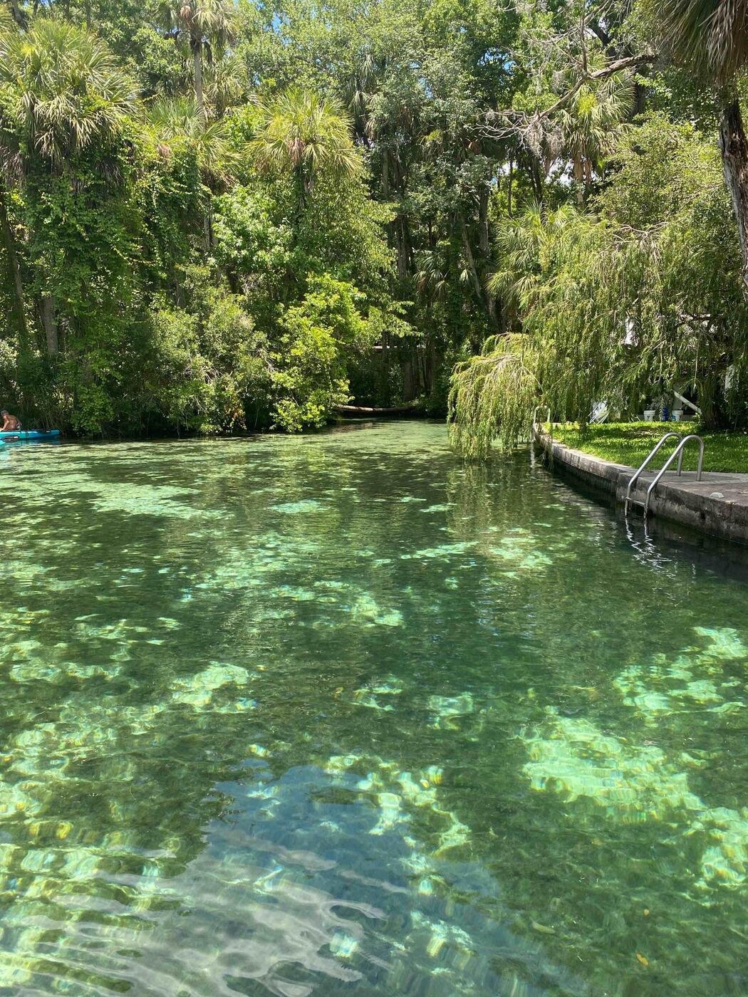
Seagrass restoration was key to protecting the shorelines and various species.
While the decision to install WADs was a critical first step in restoring the Causeway shoreline on its own, it also contributed to the success of our seagrass restoration efforts. A healthy seagrass population serves as a buffer to the shoreline, provides the basis of life for the various species that depend on the Lagoon for their survival. Our partner Sea and Shoreline, Inc., a company that focuses on seagrass restoration throughout Florida, conducted vital seagrass surveys throughout the project. Having worked with their team on several estuarine and restoration projects, I was confident in their findings. We determined the WADs aid in the recovery and restoration of seagrass meadows.
It was also necessary to reinforce the seagrass species that were left intact. The project included an emphasis on shoreline seagrass planting, focusing on seagrass meadows and other native, salt-tolerant herbaceous seagrass species to support shoreline stabilization, but not obstruct shuttle launch viewing and other recreational activities. Seagrass restoration will provide additional support to the ecosystem’s fundamental function and the functions that seagrass meadows provide to fish and wildlife.
Third Line of Defense: Return to Native Living Shoreline
With the plans to install WADs and fortify the existent seagrass along the shoreline, our first two lines of defense, that left reviving the Causeway’s native living shoreline as our final solution. Previous attempts to restore the shoreline include the installation of rocky riprap, commonly used to protect shoreline erosion, failed and hindered residents and tourists from not fully enjoying recreational activities. The wave model, calculating the WAD’s effectiveness, projected a 90 percent reduction of wave energy under normal conditions, even with extreme hurricane-force winds. Once the wave energy is substantially reduced, there is no longer a need for riprap and the shoreline can consist of native species and sandy stretches of shoreline to benefit the recreational users and wildlife in tandem.
A fully functioning shoreline, with sand and void of riprap, would not only serve the residents and tourists, but the 20 to 30 species of wildlife including shorebirds, various marine species, and horseshoe crabs, that depend on the vitality of the shoreline for life. In discussion with local environmentalists and concerned residents, perhaps no other species is more dependent on the restoration of the Causeway shoreline than the horseshoe crab. The Titusville Causeway Shoreline has been identified as one of the most important areas for the crab species to mate because of its’ fairly protected shoreline and location within the Central Indian River Lagoon. The goal is to remove all of the concrete rip rap along the shoreline and return it to a shoreline where residents, tourists can enjoy it and the various species that depend on it can thrive.
.jpg?v=1644271160604)
Rocky riprap, pictured, is commonly used to protect the shoreline from erosion.
Additional Benefits: The Stabilization of State Road 406
Along with the shoreline’s destabilization and erosion, the right-of-way along State Road 406 was significantly damaged and nearly washed away. Last year, The Florida Department of Transportation (FDOT) conducted maintenance activities to stabilize the road, such as placement of fill and stone, but that is not a successful long-term solution. Our team’s restoration efforts will provide a permanent protection solution that includes the installation of WADs, living shoreline improvement and seagrass restoration.
This project is such a great example of how innovation, environmental principles, and great partnerships with subconsultants, agencies, and the public, can create impactful change. All of us working together truly accomplished our mission of solving the puzzle of bringing the true beauty and purpose back to the Titusville Causeway Shoreline and protecting the Indian River Lagoon.
Ryan Mitchell, PE, serves as a Manager and Project Manager in DRMP's Raleigh, N.C., office.
Share This Page


.jpg?v=1643831917078)


.jpg?v=1644271160604)
