- Discover
-
Expertise
-
Alternative Delivery
- I-275 at I-4 Downtown Tampa Interchange Design-Build
- Wekiva Parkway Section 8 Interchange
- US 17/92 Interchange at SR 436
- SR 9B Extension from I-95 to US 1
- A. Max Brewer Bridge Replacement
- I-95 Widening from the Indian River/Brevard County Line to Malabar Road
- SR 528 (Beachline Expressway) at Innovation Way Interchange
- SR 570 Polk Parkway Widening from I-4 to Pace Road
- I-95 Express Lanes and Ramp Signals – Phase 3A-1
- Pollard Road Extension over Peace Creek
- I-485 Widening from I-77 to Rea Road
- Monroe Bypass/Connector Design-Build
- Construction Services
- Ecological Services
-
Federal Services
- Range of the Future Study
- US Coast Guard Air Station (Clearwater)
- Ascension Island Fire Station Renovation
- Patrick Space Force Base Water Lines Repair
- Patrick Space Force Base Living Shoreline Restoration
- P-505 Electrical Hardening and Black Start CHP at Marine Corps Air Station Beaufort
- Naval Station at Guantanamo Bay Survey Services
- Repair Phillips Parkway and Speed Limit Study
- Ascension Island Auxiliary Airfield Surveying and Mapping Services
-
Geographic Information Systems (GIS)
- Thermal Design/Comprehensive Campus LiDAR Collection
- Greater Orlando Aviation Authority (GOAA) Strategic Commerical Land Development Program
- University of Florida Sanitary Sewer GIS Mapping
- Ascension Island Auxiliary Airfield GIS Integration
- Santa Rosa County School District's School Transportation & Capacity GIS Analysis
- Gainesville Community Redevelopment Agency Socioeconomic Analysis and Site Suitability Report
- Real Estate Site Suitability and Development Analysis
- SR 836 (Dolphin Expressway) GIS Asset Inventory of Pre-Post Construction
- Alachua County Public Schools GIS and School Planning Professional Services
- Patrick Space Force Base Living Shoreline Restoration GIS Analysis
- Florida Army National Guard Readiness Center GIS Inventory & Integration
- Comprehensive Transit Study Puerto Rico GIS Analysis
- Land Development
- Structural Engineering
-
Subsurface Utility Engineering (SUE)
- Thermal Design/Comprehensive Campus LiDAR Collection
- P-505 Electrical Hardening and Black Start CHP at Marine Corps Air Station Beaufort
- Resurface & Safety Improvements Turnpike Mainline
- University of Florida Rabon Utility Mapping
- FP&L Subsurface Utility Engineering Continuing On-Call Contract
- Lockheed Martin Subsurface Utility Engineering Services
- Palm Coast Parkway Subsurface Utility Engineering Services
- Surveying & Mapping/Geospatial
-
Traffic Impact Analysis
- 505 West Chapel Hill Street
- 5th Street Station
- Beale Farm Industrial Park
- Blue Mountain Mist Resort
- The Villages at McCullers Walk
- Fredericksburg National Baseball Stadium
- Hendrick Southpoint Auto Mall
- Apex Friendship Elementary School
- Whole Foods Center
- Barclay West
- Grove 98
- Pullen Drive Extension/Catholic Diocese
- Trails/Parks & Recreation Facilities
- Transportation
-
Utilities Engineering
- Ascension Island Fire Station Renovation
- M-1 Canal Water Main Extension
- 5th Street Bridge Utility Replacement
- Captain’s Cove Wastewater Plant Revisions & Permit Renewal
- City of Fort Myers Downtown Utility & Streetscape Improvement
- Florida Caverns State Park Lift Station Rehab
- Tween Waters Inn Wastewater Plant Permit Renewal
- City of Fort Myers Wastewater Capacity Studies
- Patrick Space Force Base Water Lines Repair
- Big Lagoon Boat Ramp Wastewater System
- St. Joseph State Park Septic Tank Replacement
- WildBlue Development Wastewater Modeling
- A-1 Gator Wastewater Capacity Increase
- Water Resources/Stormwater Management
-
Alternative Delivery
- Careers
- News
- #DRMPerspective
- Team With Us
- Locations

DRMP Designs Smart Transportation for North Carolina’s I-485 Widening Project
September 8th, 2022


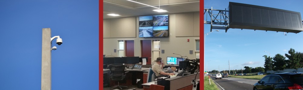
We live in a society where cameras are everywhere. You may have noticed cameras along freeways and at interchanges while driving. Closed-circuit television (CCTV) systems have long been used on highways to monitor traffic flow and verify vehicle crashes. These cameras are an integral part of Intelligent Transportation Systems (ITS).
In Charlotte, N.C., DRMP is designing roadway, bridge, and ITS, for the $83 million I-485 Widening from I-77 to Rea Road project. This job is a North Carolina Department of Transportation (NCDOT) and North Carolina Turnpike Authority (NCTA) design-build project. It involves the design and construction of separated toll lanes on a controlled access facility, beginning west of the I-77/I-485 interchange in Mecklenburg County, following existing I-485 for approximately 20 miles, ending east of the interchange of I-485 and U.S. Route 74.
This section of I-485 is one of the most congested roadways in North Carolina, averaging between 110,000 and 135,000 vehicles per day.
WSP USA, the lead design firm on this project, contracted with DRMP to lead the ITS portion of the design. DRMP prepared the plans and Special Provisions for three-fourths of the ITS work (about 15 miles) and WSP did one-fourth of the work. DRMP is the lead designer for the ITS on the project.
DRMP's work on this project is primarily comprised of creating two communications systems – one new toll and one expanded ITS – to connect the existing, relocated, and new ITS devices as well as to incorporate the new All Electronic Tolling (AET) locations into the existing fiber infrastructure in the area. The ITS devices include closed circuit television (CCTV), microwave vehicle detection (MVD), and dynamic message signs (DMS).
Part of what makes the system intelligent is being able to transmit transportation information to a manned centralized traffic management center to be able to collect, analyze, and act on it. The communication networks being added under this project tie back to the Metrolina Regional Transportation Management Center (MRTMC) in Mecklenburg County. From here, someone monitors traffic conditions using ITS devices, and the toll information is transmitted to NCTA for use.
DRMP is putting in the infrastructure for the communication networks that tie the ITS devices to the MRTMC so the information can be useful. There are basically two pieces of design work – the communications infrastructure and then the ITS devices design. Once the infrastructure along the corridor is designed, the best location for each of the ITS devices is selected.
One of DRMP’s key contributions to this project was designing the general architecture of two communication systems along the corridor - essentially outlining how information flows between field devices and the MRTMC for both networks. The ITS communications network was already in place and was extended as part of this project, while the toll communication network was designed as a new system.
Benefits of ITS
The concept of ITS is not new – it has been evolving for decades alongside advances in technology. ITS aims to enhance transportation safety, reliability, and mobility by monitoring traffic conditions, including incidents, and delivering real-time information to the public and emergency responders.
One of the most recognizable tools for sharing information with the public is the Dynamic Message Sign (DMS). These electronic highway signs provide drivers with real-time traffic updates. Larger DMS units can display travel times, crash alerts, detour instructions, and other important roadway safety messages.
Much of this information is gathered through the CCTV system. MRTMC personnel use it to verify the location of accidents and coordinate responses with emergency services. For stalled vehicles or motorists in need of assistance, the MRTMC can also dispatch Incident Management Assistance Patrol (IMAP) personnel to provide help as quickly as possible. In cases of major congestion or significant crashes, incident management plans may be implemented to guide drivers to detour routes along the corridor.
Beyond visual monitoring, data is also collected from microwave vehicle detection devices (MVDs), which support decision-making at the MRTMC. These sensors provide vehicle counts, lane occupancy, and speed data – helping to confirm or supplement what may not be visible via CCTV. NCTA also uses this data to assess roadway conditions and determine express lane pricing. Because these sensors serve multiple purposes, they are deployed extensively across the project corridor.
Only Second Express Lane System in North Carolina
There are no other toll roads on I-485 around Charlotte, making this 20-mile section a standalone express lane system that will integrate into the broader NCDOT/NCTA network. It features multiple ITS devices working together in an interconnected, interdependent system. This is only the second expressway in North Carolina to include separated tolled express lanes.
The first was I-77, developed under a public–private partnership to leverage private funding and accelerate project delivery compared to traditional state funding. At the time this project was being designed, the I-77 express lanes were still under construction, meaning NCDOT and NCTA had limited insight into how the system would perform in practice. As a result, this is the first ITS design of its kind for an NCDOT/NCTA-led expressway project.
This ITS project is divided into two parallel systems: general-purpose lanes and express lanes. The general-purpose lanes function like typical freeway lanes, open to all traffic. The express lanes, located in the center of I-485, are tolled managed lanes separated from general-purpose lanes by plastic tubular markers. Since both lane types carry traffic in the same direction, these flexible markers provide a safe, cost-effective separation – they are designed to collapse and rebound if struck, unlike rigid concrete barriers.
The tolled express lanes aim to improve traffic flow by offering drivers a choice. When general-purpose lanes are congested, drivers can opt to pay a toll for a more reliable trip in the express lanes. At each end of the 20-mile corridor, a DMS will display real-time speed and travel time information for both lane types. This helps drivers assess whether the toll cost is worth the potential time savings.
The express lanes use a variable toll system, where prices fluctuate based on traffic conditions during peak and off-peak periods. Smaller DMS signs along the corridor display current toll rates, similar to those used for travel time updates. MVDs are installed throughout the corridor to support this system – not only counting vehicles but also monitoring speed data. The slower traffic moves in the general-purpose lanes, the greater the value of the express lanes becomes.
Coordination
DRMP coordinated directly with the NCDOT ITS section and NCTA for plan approvals. We also worked closely with the MRTMC to review existing fiber architecture, gather equipment information, and plan proposed routing using the existing fiber network. In addition, we collaborated with numerous other agencies and consultants throughout the project.
Given the interconnected nature of the project components, coordination was essential with the design teams for AET, roadway, pavement markings, and signing. One of our primary responsibilities was designing the communications for the toll system. DRMP’s design connected the AET equipment, making collaboration with the AET designers critical to the success of the system.
We also addressed the power supply needs for ITS devices, coordinating with Duke Energy, Pineville Power, and Union County Power to identify service points for all new equipment.
Coordination extended to the sign design as well. Both large and small dynamic message signs were integrated into the overhead sign structures, requiring alignment with the sign design team for accurate placement.
This was a complex and collaborative project involving the integration of two separate communication systems along a single corridor and routing them back to one centralized location — a significant step in advancing North Carolina’s ITS and tolling infrastructure.
Posted in the categories All, Alternative Delivery, Transportation, Transportation Planning/Project Development .
Related Articles
 Nov13DRMP Makes Streets Safer and More Accessible Through Multimodal Transportation Safety PlanningTransportation impacts how we live, work...See Details
 Nov13DRMP Delivers Safer, Smarter Streets Through Multimodal Transportation Safety DRMP provides Multimodal Transportation ...See Details
 Oct23DRMP’s TIA Expertise Clears the Way for Southeast Industrial GrowthWith industrial development rapidly expa...See Details
 Oct22Meet the Instructional Designer Reinventing Learning at DRMPInstructional designers are expert trans...See Details

Categories
- All
- Alternative Delivery
- Civil Services
- Construction Services
- Disaster Resilience and Sustainability
- DRMPCares
- Ecological Services
- Electrical Engineering
- eWIRE
- Federal Services
- Geographic Information Systems
- Hurricane
- Land Development
- Learning & Development
- NEPA
- Project Development & Environment
- Structural Engineering
- Subsurface Utility Engineering
- Surveying & Mapping
- Traffic Impact Analysis
- Transportation
- Transportation Planning/Project Development
- Utilities Engineering
- Water Resources/Stormwater Management
Contributors
- Michael K. Albano, PE
- Bruno J. Arriola, PE, ENV SP
- Alia Awwad, PE
- Brent Bass, PE, PSM
- Cody Bayer, PE
- Maria Bazemore, PWS, AICP
- Paul Benvie, PE
- Donald W. Brown, PE
- Kyle Brown, PE
- Jake Burton
- Zach J. Carnahan, PE
- Brian Crowl, PE
- Patrick Day, PE
- Nick DeVito, PE
- Matt Floyd, PSM
- Deshon M. Fox, PE
- Scott Garth, PE, LEED AP ND
- Ryan M. Grab, CST II
- Robyn Hartz, INCE
- Justin Hayes, EI
- Lucas S. Helms, PE
- Jim Highland, PE
- Ryan Ianacone, CST II
- David Johnson, PE
- TJ Lallathin, Jr., PE, DBIA
- Jay McInnis, PE, CPM
- George McLatchey, PWS, CEP
- Michael McNeese
- Ryan Mitchell, PE
- Megan E. Mott, PE
- Josh Norman
- Melissa Padilla Cintron, SIT
- Pavan Paiavula, PE
- Ryan Pellarin, PE, CCM
- AJ Perkinson, PLS
- Julian Poole, PE
- Kayla Poulos, PE
- Joce Pritchett, PE
- Leo Rodriguez, PE
- John Schick
- Rachel L. Schmidt, PWS
- Logan Shappell
- Rynal Stephenson, PE
- Albert Taylor
- Deston Taylor, PE, PTOE
- Keelyn Taylor, PhD
- August Thick II, PLS, CST III
- Orville Williams
- Amanda E. Woods, PE


