To innovative engineers, roadways are much more than pathways that take us from point A to B. They are integral parts of our environmental and social ecosystems that allow modern societies to function as connected communities.
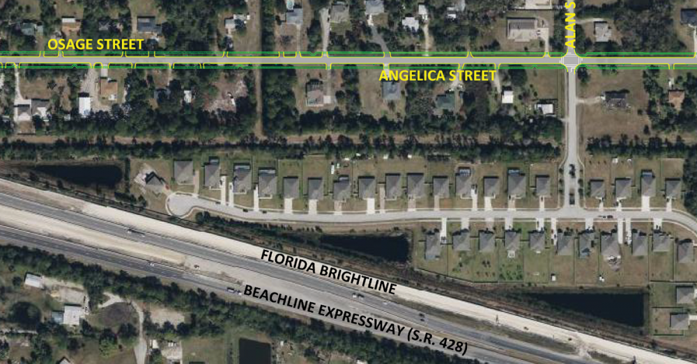
Let us look at the Angelica-Osage roadway improvement project in Brevard County, Fla., currently under design by DRMP. At first glance, the project is another typical roadway improvement venture: new asphalt roads with adjacent swales and sidewalks. A closer look at the project reveals an opportunity to improve a 1-mile rural stretch of County-owned public Right of Way (ROW) in an environmentally responsible manner.
The Angelica-Osage continuous corridor will act as the only access road connecting a new planned residential community to Grissom Parkway. Consequently, improving this corridor is essential to handle the expected increase in traffic and pedestrian activity.
This limited ROW—bounded on the north and south by residential lots with some built houses—must accommodate the proposed asphalt roadway, engineered treatment swales, and sidewalks on both sides of the two-lane road.
The project will increase adjacent property values and manage stormwater in the area, while serving as a safe gateway to a newly planned residential community in the initial stages of development at the west end of the corridor.
More importantly, the new road, once built, will provide the planned community to the west and the existing residential lots adjacent to the ROW with an amenity for outdoor activity, such as walking for exercise and dog walking.
Sophisticated Design Approaches
The task before the DRMP design team seemed straightforward; however, the existing condition of the corridor posed challenges requiring sophisticated design approaches.
The project area consists of two contiguous partially paved dirt roads crossed intermittently by water-filled ditches, bounded by overgrown organically shaped swales and single-family lots. DRMP’s design team approached the project by allocating segments of the design to team members with specialized expertise in particular areas.
Using survey topographic data provided by DRMP’s surveyors and geotechnical data provided by a sub-consultant, the lead drainage designer used the Advanced Interconnected Pond Routing (adICPR) stormwater software to model hydrologic and hydraulic pre-and-post construction conditions of the drainage basin.
The model established several fundamental parameters of the design, including roadway elevations, swale dimensions, control structure locations, drainage pipe alignments, ditch block locations, and the dimensions of a dry detention pond.
A second drainage engineer performed a secondary analysis of the drainage pipes throughout the system. They used stormwater flow volumes generated by the post condition adICPR model. The goal was to ensure adequate pipe sizes are specified, which would provide adequate stormwater storage and flow rates to predetermined outfall zones. It aims to prevent flooding of roads or adjacent properties during a 100-year, 24-hour storm event.
Additionally, AutoCAD Civil 3D, a powerful software commonly used by civil engineers, was used to generate pre- and post-condition surface elevations across the width of the ROW, allowing dynamic cross-sections to be generated at any point along the ROW alignment. The dynamic nature of the cross-sections means that the cross-sections update automatically with any grade changes to the proposed surface, saving valuable time during the iterative design process.
Project Turnaround
The Angelica-Osage road improvement civil engineering designs are ongoing. Sixty percent design plans have been completed and provided to the Client and County for a progress review. Internal quality control reviews are being conducted, as per detailed protocols established by our Orlando-based civil engineering team at DRMP, to ensure the final design deliverables represent best engineering practices and adherence to relevant design guidelines of the County, City, and St. John’s Water Management District.
The design effort to take the plans to 100 percent completion will include fine-tuning of the adICPR model and the secondary analysis calculations, checks of proposed ground elevations, and stormwater pipes to avoid conflicts with proposed underground utility upgrades along the ROW (DRMP recently secured construction approval for utility upgrades along the same corridor) and further coordination with review agencies.
The end result, after more than six months of collaborative design effort, will be construction plans for a two-lane, professionally designed roadway that represents a significant enhancement of the existing, rural road. As such, the new roadway will become more than a path for vehicles to move from point A to B, but a durable feature of the community that symbolizes social connectivity and progress within the built environment.
Deshon M. Fox, PE, is DRMP's Central Florida Department Manager for General Civil Municipal Market Sector


