- Discover
-
Expertise
-
Alternative Delivery
- I-275 at I-4 Downtown Tampa Interchange Design-Build
- Wekiva Parkway Section 8 Interchange
- US 17/92 Interchange at SR 436
- SR 9B Extension from I-95 to US 1
- A. Max Brewer Bridge Replacement
- I-95 Widening from the Indian River/Brevard County Line to Malabar Road
- SR 528 (Beachline Expressway) at Innovation Way Interchange
- SR 570 Polk Parkway Widening from I-4 to Pace Road
- I-95 Express Lanes and Ramp Signals – Phase 3A-1
- Pollard Road Extension over Peace Creek
- I-485 Widening from I-77 to Rea Road
- Monroe Bypass/Connector Design-Build
- Construction Services
- Ecological Services
-
Federal Services
- Range of the Future Study
- US Coast Guard Air Station (Clearwater)
- Ascension Island Fire Station Renovation
- Patrick Space Force Base Water Lines Repair
- Patrick Space Force Base Living Shoreline Restoration
- P-505 Electrical Hardening and Black Start CHP at Marine Corps Air Station Beaufort
- Naval Station at Guantanamo Bay Survey Services
- Repair Phillips Parkway and Speed Limit Study
- Ascension Island Auxiliary Airfield Surveying and Mapping Services
-
Geographic Information Systems (GIS)
- Thermal Design/Comprehensive Campus LiDAR Collection
- Greater Orlando Aviation Authority (GOAA) Strategic Commerical Land Development Program
- University of Florida Sanitary Sewer GIS Mapping
- Ascension Island Auxiliary Airfield GIS Integration
- Santa Rosa County School District's School Transportation & Capacity GIS Analysis
- Gainesville Community Redevelopment Agency Socioeconomic Analysis and Site Suitability Report
- Real Estate Site Suitability and Development Analysis
- SR 836 (Dolphin Expressway) GIS Asset Inventory of Pre-Post Construction
- Alachua County Public Schools GIS and School Planning Professional Services
- Patrick Space Force Base Living Shoreline Restoration GIS Analysis
- Florida Army National Guard Readiness Center GIS Inventory & Integration
- Comprehensive Transit Study Puerto Rico GIS Analysis
- Land Development
- Structural Engineering
-
Subsurface Utility Engineering (SUE)
- Thermal Design/Comprehensive Campus LiDAR Collection
- P-505 Electrical Hardening and Black Start CHP at Marine Corps Air Station Beaufort
- Resurface & Safety Improvements Turnpike Mainline
- University of Florida Rabon Utility Mapping
- FP&L Subsurface Utility Engineering Continuing On-Call Contract
- Lockheed Martin Subsurface Utility Engineering Services
- Palm Coast Parkway Subsurface Utility Engineering Services
- Surveying & Mapping/Geospatial
-
Traffic Impact Analysis
- 505 West Chapel Hill Street
- 5th Street Station
- Beale Farm Industrial Park
- Blue Mountain Mist Resort
- The Villages at McCullers Walk
- Fredericksburg National Baseball Stadium
- Hendrick Southpoint Auto Mall
- Apex Friendship Elementary School
- Whole Foods Center
- Barclay West
- Grove 98
- Pullen Drive Extension/Catholic Diocese
- Trails/Parks & Recreation Facilities
- Transportation
-
Utilities Engineering
- Ascension Island Fire Station Renovation
- M-1 Canal Water Main Extension
- 5th Street Bridge Utility Replacement
- Captain’s Cove Wastewater Plant Revisions & Permit Renewal
- City of Fort Myers Downtown Utility & Streetscape Improvement
- Florida Caverns State Park Lift Station Rehab
- Tween Waters Inn Wastewater Plant Permit Renewal
- City of Fort Myers Wastewater Capacity Studies
- Patrick Space Force Base Water Lines Repair
- Big Lagoon Boat Ramp Wastewater System
- St. Joseph State Park Septic Tank Replacement
- WildBlue Development Wastewater Modeling
- A-1 Gator Wastewater Capacity Increase
- Visualization Services
- Water Resources/Stormwater Management
-
Alternative Delivery
- Careers
- News
- #DRMPerspective
- Team With Us
- Locations


DRMP’s GIS Solutions Support Hillsborough County Public Schools in Planning for the Future
September 10th, 2024


Running a school district of 220,000 students is a large and complicated job, but one that is made easier for Hillsborough County Public Schools, the seventh largest school district in the country, with the help of DRMP’s GIS team.
Since 2023, DRMP has provided web mapping application development and data management services to HCPS’ Growth Management and Planning Department. What originally started as an initial project to create specific data viewing and reporting web applications for the department has evolved into providing a wide range of services and assistance, ranging from a product used by the public to tools custom-designed to support planning staff in their decision-making processes.
DRMP’s GIS Tool Simplifies Finding Your School Zone
DRMP’s GIS team created and manages a public-facing School Locator web map to make it easy for students and families to determine their zoned schools. The tool combines county-wide address point data with HCPS school zone boundaries, providing clear, updated information that is useful not just for currently enrolled students but also the community at large.
DRMP created the School Locator viewer with the user experience in mind. We considered what parents and guardians would need, offering quick links to resources, such as school choice, transportation, and enrollment. Each search within the School Locator tool links directly to the relevant school and provides the user with detailed information including the school’s address, map location, phone number, and link to the school’s website.
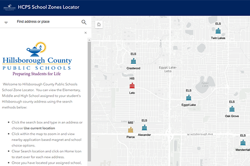
The home screen of the Hillsborough County Schools Zone Locator Application displaying school locations in Tampa.
GIS Project Manager Mark Brown, GISP, and GIS Analyst Ravneet Kathuria, played key roles in designing the autofill functionality of the School Locator and keeping the address information up to date as new addresses are created county-wide every day. According to Mark, one of the largest challenges in creating this product was incorporating the functionality of returning not just the zoned schools for the current school year, but also the next year’s school zones for an address. Because of rezoning, school closures and newly opened schools, school zone boundaries need to be updated for each year.

The HCPS School Locator Application displaying the zoned elementary and middle schools for the DRMP Tampa office address.
Since its launch in July 2023, the School Locator has become a go-to resource, helping hundreds of thousands of users get the information they need with just a few clicks. The School Locator has been accessed over 289,000 times since its inception and is updated annually between school years.
Planning for Growth Using Geographic Data
In addition to the School Locator, our GIS team also handles student address geocoding for the Hillsborough County Growth Management and Planning Department. This involves updating a detailed point address layer for every student address in the county every 20 school days. By matching student addresses with county address point data, we help the Growth Management and Planning Department track enrollment trends and manage zoning boundaries effectively. This process is vital for understanding where students live and planning for future infrastructure needs. GIS is a lot of things, but it’s ultimately where geographic information and databases meet each other. Being trusted to manage and analyze student data is a big responsibility, but one that we take seriously. We know that each data point is a real student who will take a unique path through their time with the school district.

The DRMP GIS team (from left to right: Meaghan McCarthy, Kelly Marton, Ravneet Kathuria, and Mark Brown) after meeting with the HCPS Growth Management and Planning staff in downtown Tampa.
The GIS team is also working on a planning tool that will give the Growth Management Department instant access to critical data through a web application. This new tool will allow for on-the-fly report generation and data retrieval, which helps streamline the Department’s operations and make the information more accessible to HCPS employees.
Our GIS expertise also helps the Department evaluate how new housing projects will affect local schools. By estimating the potential number of students from new residential development projects, we help the Department plan for capacity and the need for new schools. This ensures new developments are thoughtfully incorporated into the community’s educational infrastructure.
With the expertise of DRMP’s GIS team, Hillsborough County Public Schools can manage the challenges of growth and planning more effectively. From helping families find their zoned schools to forecasting the impact of new housing developments, our GIS solutions are an integral part of making informed decisions that shape the future of education in the community.

Kelly M. Marton, GISP, serves as a GIS Project Manager for DRMP’s Survey and Mapping/Geospatial Market Sector.
Posted in the categories All, Geographic Information Systems.
Related Articles
 Aug29DRMP’s Environmental Services Help Guide the Future of DeLand's Lake Moore Conservation AreaDRMP’s Environmental Services Group he...See Details
 Aug27DRMP's PD&E Study Supports Mexico Beach, Fla., Revitalization with Multi-Use PathDRMP's multi-use path project along SR 3...See Details
 Aug20DRMP Traffic Experts Provide Solutions for Safer School CommutesDRMP’s traffic engineers are dedicated...See Details
 Aug15Fulfilling a Long-Time Dream at the 5th Annual Women Surveyors Summit 2024The Women Surveyors Summit 2024, held in...See Details

Categories
- All
- Featured Posts
- Alternative Delivery
- Construction Services
- Disaster Resilience and Sustainability
- Ecological Services
- Federal Services
- Geographic Information Systems
- Land Development
- NEPA
- Project Development & Environment
- Structural Engineering
- Subsurface Utility Engineering
- Surveying & Mapping
- Traffic Impact Analysis
- Transportation
- Transportation Planning/Project Development
- Utilities Engineering
- Water Resources/Stormwater Management
Contributors
- Michael K. Albano, PE
- Bruno J. Arriola, PE, ENV SP
- Brent Bass, PE, PSM
- Cody Bayer, PE
- Donald W. Brown, PE
- Kyle Brown, PE
- Michael Bywaletz, PE, CPESC, ENV SP
- Zach J. Carnahan, PE
- Brian Crowl, PE
- Patrick Day, PE
- Nick DeVito, PE
- Matt Floyd, PSM
- Deshon M. Fox, PE
- Scott Garth, PE, LEED AP ND
- Ryan M. Grab, CST II
- Robyn Hartz
- Jim Highland, PE
- TJ Lallathin, Jr., PE, DBIA
- Kelly Marton, GISP
- Meaghan McCarthy
- George McLatchey, PWS, CEP
- Michael McNeese
- Jeff Miller
- Ryan Mitchell, PE
- Lisa Moon, PE
- Megan E. Mott, PE
- Josh Norman
- Melissa Padilla Cintron, SIT
- Pavan Paiavula, PE
- Julian Poole, PE
- Joce Pritchett, PE
- Abby Rains
- Leo Rodriguez, PE
- Rachel L. Schmidt, PWS
- Logan Shappell
- Brian V. Smith
- Rynal Stephenson, PE
- Deston Taylor, EI
- August Thick, PLS
- Ron Wallace, PE
- Steven L. Wallace, PE
- Orville Williams
- Amanda E. Woods, PE


