- Discover
-
Expertise
-
Alternative Delivery
- I-275 at I-4 Downtown Tampa Interchange Design-Build
- Wekiva Parkway Section 8 Interchange
- US 17/92 Interchange at SR 436
- SR 9B Extension from I-95 to US 1
- A. Max Brewer Bridge Replacement
- I-95 Widening from the Indian River/Brevard County Line to Malabar Road
- SR 528 (Beachline Expressway) at Innovation Way Interchange
- SR 570 Polk Parkway Widening from I-4 to Pace Road
- I-95 Express Lanes and Ramp Signals – Phase 3A-1
- Pollard Road Extension over Peace Creek
- I-485 Widening from I-77 to Rea Road
- Monroe Bypass/Connector Design-Build
- Construction Services
- Ecological Services
-
Federal Services
- Range of the Future Study
- US Coast Guard Air Station (Clearwater)
- Ascension Island Fire Station Renovation
- Patrick Space Force Base Water Lines Repair
- Patrick Space Force Base Living Shoreline Restoration
- P-505 Electrical Hardening and Black Start CHP at Marine Corps Air Station Beaufort
- Naval Station at Guantanamo Bay Survey Services
- Repair Phillips Parkway and Speed Limit Study
- Ascension Island Auxiliary Airfield Surveying and Mapping Services
-
Geographic Information Systems (GIS)
- Thermal Design/Comprehensive Campus LiDAR Collection
- Greater Orlando Aviation Authority (GOAA) Strategic Commerical Land Development Program
- University of Florida Sanitary Sewer GIS Mapping
- Ascension Island Auxiliary Airfield GIS Integration
- Santa Rosa County School District's School Transportation & Capacity GIS Analysis
- Gainesville Community Redevelopment Agency Socioeconomic Analysis and Site Suitability Report
- Real Estate Site Suitability and Development Analysis
- SR 836 (Dolphin Expressway) GIS Asset Inventory of Pre-Post Construction
- Alachua County Public Schools GIS and School Planning Professional Services
- Patrick Space Force Base Living Shoreline Restoration GIS Analysis
- Florida Army National Guard Readiness Center GIS Inventory & Integration
- Comprehensive Transit Study Puerto Rico GIS Analysis
- Land Development
- Structural Engineering
-
Subsurface Utility Engineering (SUE)
- Thermal Design/Comprehensive Campus LiDAR Collection
- P-505 Electrical Hardening and Black Start CHP at Marine Corps Air Station Beaufort
- Resurface & Safety Improvements Turnpike Mainline
- University of Florida Rabon Utility Mapping
- FP&L Subsurface Utility Engineering Continuing On-Call Contract
- Lockheed Martin Subsurface Utility Engineering Services
- Palm Coast Parkway Subsurface Utility Engineering Services
- Surveying & Mapping/Geospatial
-
Traffic Impact Analysis
- 505 West Chapel Hill Street
- 5th Street Station
- Beale Farm Industrial Park
- Blue Mountain Mist Resort
- The Villages at McCullers Walk
- Fredericksburg National Baseball Stadium
- Hendrick Southpoint Auto Mall
- Apex Friendship Elementary School
- Whole Foods Center
- Barclay West
- Grove 98
- Pullen Drive Extension/Catholic Diocese
- Trails/Parks & Recreation Facilities
- Transportation
-
Utilities Engineering
- Ascension Island Fire Station Renovation
- M-1 Canal Water Main Extension
- 5th Street Bridge Utility Replacement
- Captain’s Cove Wastewater Plant Revisions & Permit Renewal
- City of Fort Myers Downtown Utility & Streetscape Improvement
- Florida Caverns State Park Lift Station Rehab
- Tween Waters Inn Wastewater Plant Permit Renewal
- City of Fort Myers Wastewater Capacity Studies
- Patrick Space Force Base Water Lines Repair
- Big Lagoon Boat Ramp Wastewater System
- St. Joseph State Park Septic Tank Replacement
- WildBlue Development Wastewater Modeling
- A-1 Gator Wastewater Capacity Increase
- Water Resources/Stormwater Management
-
Alternative Delivery
- Careers
- News
- #DRMPerspective
- Team With Us
- Locations


How LiDAR and GIS are Modernizing Road Sign Inventories for Safer Travel in West Virginia
January 9th, 2025


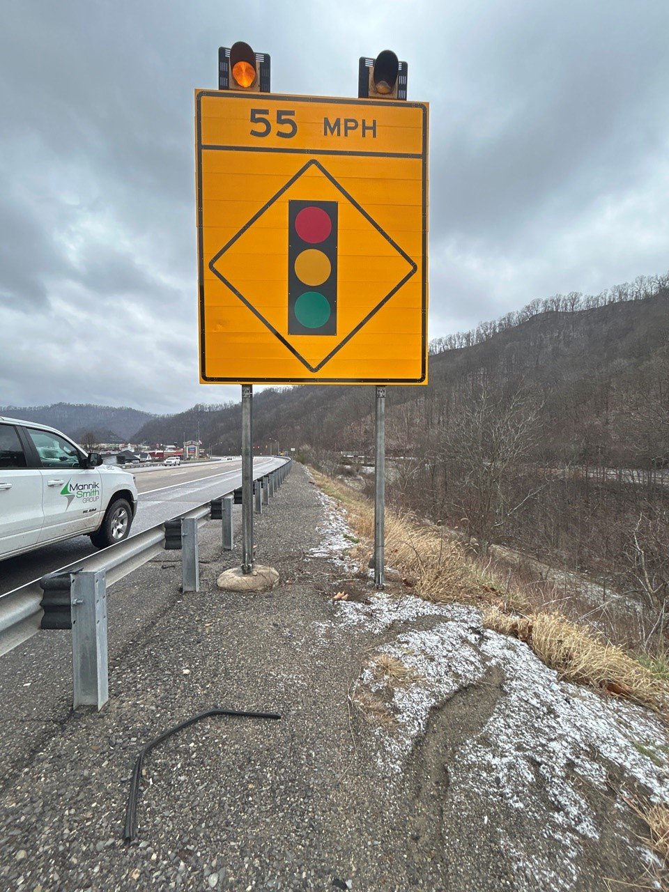
The West Virginia Division of Highways (WVDOH) needed a solution to modernize its road sign inventory and identify areas for updates or replacements along a stretch of US 19—a vital part of the Appalachian Development Highway System, a 3,090-mile network of 33 highway corridors connecting the 13 Appalachian states to the Interstate Highway System.
From outdated fonts to incorrect placements, signs that don’t meet regulatory standards can now be identified and addressed, ensuring roadways not only meet safety requirements but also provide clear and consistent information to drivers.
As a subconsultant to our sister firm, the Mannik & Smith Group, we began assisting with this project starting with a stretch of US 19 in Braxton and Nicholas counties to assess road sign conditions and locations by using Geographic Information Systems (GIS) and mobile LiDAR. Our first task involved scanning 1,500 sign assemblies along Corridor L of the Appalachian Development Highway System.
Identifying Signs
The first step in the process was understanding what signage already existed. Our mobile LiDAR vehicle scanned the corridor and captured detailed spatial data. This data was then processed to extract information on each sign assembly — the support structures and the signs they hold.
One assembly can include multiple sign panels. For this project, the most complex assembly held 16 panels. Our team recorded important details, such as the distance from the road, the type and length of supports, and spacing between them. Each assembly was assigned a unique ID and compiled into an automated report that included photos and measurements for the 1,500 assemblies. This inventory information allows engineers to assess the condition of the signs, decide what can remain, and identify what needs replacement.
Enhancing Fieldwork with GIS
While the LiDAR scans provided a wealth of information, some of the finer details on the front and back of the signs required in-person verification. That’s where our GIS expertise came in. We used ArcGIS Field Maps to create a mobile application for Mannik & Smith’s field crews to access sign locations, add precise photos, and collect additional data. This app helped streamline the fieldwork and cut down time spent on-site. Crews could focus on gathering high-quality images and verifying information instead of manually measuring and recording each assembly.

This hybrid approach of LiDAR and GIS optimized efficiency, reducing travel time and minimizing the risk to field staff working on busy roads. Without LiDAR, crews would have needed ladders, tape measures, and GPS units to measure and document each sign manually, and some of the signs were as high as 16 feet. Doing the work manually would have been a time-intensive and costly process. Because data was extracted in the office from LiDAR scans, our crews can drive up to each sign, click on a point on a tablet, and take the pictures they need. We’ve also used ArcGIS to inventory and map out streetlights and culverts for other projects.
Scaling for the Future
The success of this project led to being hired to perform a second task in which we used the same method to scan 250 additional assemblies along US 119 in Logan County.
Modernizing sign inventories isn’t just about compliance. It’s about providing clients with a better understanding of their assets. By mapping signs, culverts, and even streetlights, GIS provides a powerful tool for planning and decision-making. This project is an example of how technology can make infrastructure management more efficient, safer, and cost-effective.
The combination of LiDAR scans and GIS-based fieldwork isn’t just innovative — it’s transformative. There is power in knowing exactly which assets exist in the field and where they are located. As we continue to refine the process, it’s clear this type of work could become a staple of GIS applications in the transportation industry. We hope to expand this approach to other regions and potentially nationwide.
To learn more about DRMP’s GIS services, click here.
Related Articles
 Jul31Survey Says… DRMP Knows How to Celebrate Interns Each year, DRMP finds fresh, creative wa...See Details
 Jul25DRMP Delivers Hope on Two Wheels
For many families serve...See Details
Jul25DRMP Delivers Hope on Two Wheels
For many families serve...See Details Jul24DRMP's Expanding Electrical Engineering Service Charges into New Territory
When I first joined DRM...See Details
Jul24DRMP's Expanding Electrical Engineering Service Charges into New Territory
When I first joined DRM...See Details Jul16What is a Traffic Impact Analysis? And How Does It Help Plan Safe, Efficient Solutions for New Developments?A Traffic Impact Analysis (TIA), also re...See Details

Categories
- All
- Alternative Delivery
- Civil Services
- Construction Services
- Disaster Resilience and Sustainability
- DRMPCares
- Ecological Services
- Electrical Engineering
- eWIRE
- Federal Services
- Geographic Information Systems
- Hurricane
- Land Development
- Learning & Development
- NEPA
- Project Development & Environment
- Structural Engineering
- Subsurface Utility Engineering
- Surveying & Mapping
- Traffic Impact Analysis
- Transportation
- Transportation Planning/Project Development
- Utilities Engineering
- Water Resources/Stormwater Management
Contributors
- Michael K. Albano, PE
- Bruno J. Arriola, PE, ENV SP
- Brent Bass, PE, PSM
- Cody Bayer, PE
- Maria Bazemore, PWS, AICP
- Paul Benvie, PE
- Donald W. Brown, PE
- Kyle Brown, PE
- Jake Burton
- Zach J. Carnahan, PE
- Brian Crowl, PE
- Patrick Day, PE
- Nick DeVito, PE
- Matt Floyd, PSM
- Deshon M. Fox, PE
- Scott Garth, PE, LEED AP ND
- Ryan M. Grab, CST II
- Robyn Hartz, INCE
- Justin Hayes, EI
- Lucas S. Helms, PE
- Jim Highland, PE
- Ryan Ianacone, CST II
- TJ Lallathin, Jr., PE, DBIA
- Jay McInnis, PE, CPM
- George McLatchey, PWS, CEP
- Michael McNeese
- Ryan Mitchell, PE
- Megan E. Mott, PE
- Josh Norman
- Melissa Padilla Cintron, SIT
- Pavan Paiavula, PE
- Ryan Pellarin, PE, CCM
- AJ Perkinson, PLS
- Julian Poole, PE
- Joce Pritchett, PE
- Leo Rodriguez, PE
- Rachel L. Schmidt, PWS
- Logan Shappell
- Rynal Stephenson, PE
- Deston Taylor, PE, PTOE
- August Thick II, PLS, CST III
- Orville Williams
- Amanda E. Woods, PE
Recent Articles
- 07/31/25Survey Says… DRMP Knows How to Celebrate Interns
- 07/25/25DRMP Delivers Hope on Two Wheels
- 07/24/25DRMP's Expanding Electrical Engineering Service Charges into New Territory
- 07/16/25What is a Traffic Impact Analysis? And How Does It Help Plan Safe, Efficient Solutions for New Developments?
- 07/15/25GIS: The Unsung Hero Behind Smarter Communities


