- Discover
-
Expertise
-
Alternative Delivery
- I-275 at I-4 Downtown Tampa Interchange Design-Build
- Wekiva Parkway Section 8 Interchange
- US 17/92 Interchange at SR 436
- SR 9B Extension from I-95 to US 1
- A. Max Brewer Bridge Replacement
- I-95 Widening from the Indian River/Brevard County Line to Malabar Road
- SR 528 (Beachline Expressway) at Innovation Way Interchange
- SR 570 Polk Parkway Widening from I-4 to Pace Road
- I-95 Express Lanes and Ramp Signals – Phase 3A-1
- Pollard Road Extension over Peace Creek
- I-485 Widening from I-77 to Rea Road
- Monroe Bypass/Connector Design-Build
- Construction Services
- Ecological Services
-
Federal Services
- Range of the Future Study
- US Coast Guard Air Station (Clearwater)
- Ascension Island Fire Station Renovation
- Patrick Space Force Base Water Lines Repair
- Patrick Space Force Base Living Shoreline Restoration
- P-505 Electrical Hardening and Black Start CHP at Marine Corps Air Station Beaufort
- Naval Station at Guantanamo Bay Survey Services
- Repair Phillips Parkway and Speed Limit Study
- Ascension Island Auxiliary Airfield Surveying and Mapping Services
-
Geographic Information Systems (GIS)
- Thermal Design/Comprehensive Campus LiDAR Collection
- Greater Orlando Aviation Authority (GOAA) Strategic Commerical Land Development Program
- University of Florida Sanitary Sewer GIS Mapping
- Ascension Island Auxiliary Airfield GIS Integration
- Santa Rosa County School District's School Transportation & Capacity GIS Analysis
- Gainesville Community Redevelopment Agency Socioeconomic Analysis and Site Suitability Report
- Real Estate Site Suitability and Development Analysis
- SR 836 (Dolphin Expressway) GIS Asset Inventory of Pre-Post Construction
- Alachua County Public Schools GIS and School Planning Professional Services
- Patrick Space Force Base Living Shoreline Restoration GIS Analysis
- Florida Army National Guard Readiness Center GIS Inventory & Integration
- Comprehensive Transit Study Puerto Rico GIS Analysis
- Land Development
- Structural Engineering
-
Subsurface Utility Engineering (SUE)
- Thermal Design/Comprehensive Campus LiDAR Collection
- P-505 Electrical Hardening and Black Start CHP at Marine Corps Air Station Beaufort
- Resurface & Safety Improvements Turnpike Mainline
- University of Florida Rabon Utility Mapping
- FP&L Subsurface Utility Engineering Continuing On-Call Contract
- Lockheed Martin Subsurface Utility Engineering Services
- Palm Coast Parkway Subsurface Utility Engineering Services
- Surveying & Mapping/Geospatial
-
Traffic Impact Analysis
- 505 West Chapel Hill Street
- 5th Street Station
- Beale Farm Industrial Park
- Blue Mountain Mist Resort
- The Villages at McCullers Walk
- Fredericksburg National Baseball Stadium
- Hendrick Southpoint Auto Mall
- Apex Friendship Elementary School
- Whole Foods Center
- Barclay West
- Grove 98
- Pullen Drive Extension/Catholic Diocese
- Trails/Parks & Recreation Facilities
- Transportation
-
Utilities Engineering
- Ascension Island Fire Station Renovation
- M-1 Canal Water Main Extension
- 5th Street Bridge Utility Replacement
- Captain’s Cove Wastewater Plant Revisions & Permit Renewal
- City of Fort Myers Downtown Utility & Streetscape Improvement
- Florida Caverns State Park Lift Station Rehab
- Tween Waters Inn Wastewater Plant Permit Renewal
- City of Fort Myers Wastewater Capacity Studies
- Patrick Space Force Base Water Lines Repair
- Big Lagoon Boat Ramp Wastewater System
- St. Joseph State Park Septic Tank Replacement
- WildBlue Development Wastewater Modeling
- A-1 Gator Wastewater Capacity Increase
- Water Resources/Stormwater Management
-
Alternative Delivery
- Careers
- News
- #DRMPerspective
- Team With Us
- Locations

DRMP’s Wildlife Crossing Expertise Protects Florida’s Ecosystems, Public Safety, and Endangered Species
September 4th, 2025


As we celebrate National Wildlife Day, a time to raise awareness about conservation and protecting native and endangered species throughout the United States, one solution gaining popularity is wildlife crossings. These structures help enhance public safety by reducing animal-vehicle collisions, protect wildlife, and reconnect fragmented habitats.
DRMP brings decades of multidisciplinary experience to wildlife crossing projects, combining environmental science, engineering, and regulatory expertise to design solutions that protect ecosystems while meeting infrastructure goals.
State departments of transportation, local governments, along with environmental and engineering professionals, are rethinking how infrastructure intersects with the environment. Rather than creating barriers through critical habitats, they’re exploring solutions that preserve ecological connectivity and support the long-term movement and survival of wildlife.
One of the most striking examples of this trend is happening in California where the state is constructing one of the largest wildlife overpasses in the world, the Wallis Annenberg Wildlife Crossing on Highway 101 outside of Los Angeles. This bridge will span 10 lanes of highway and provide a safe passage for mountain lions, deer, and other wildlife across one of the region’s busiest roads. It’s a landmark project that highlights a growing commitment to balancing infrastructure with ecological preservation. Similarly, in Colorado, the state is building the Greenland Wildlife Overpass, which will span six lanes of interstate and serve as a critical route for elk, deer, and other species.
Here in Florida, however, we’re already seeing the benefits of this type of investment. One of the major wildlife crossing projects I’ve been personally involved in at DRMP is the I-4 at SR 557 wildlife underpass in Polk County, which was completed last year and is already making a measurable difference. Designed by DRMP’s design-build team and our Project Development and Environmental Services (PDES) team, this crossing is a lifeline for Florida’s wildlife.
As a Certified Environmental Professional (CEP), my job is to bring ecological insight and environmental permitting expertise to infrastructure projects so that roadways not only serve people but also protect and preserve the natural systems they intersect with.
Polk County’s First Wildlife Crossing
I-4 has long been considered one of the most ecologically disruptive barriers in Florida. For decades, this major interstate has functioned as an impenetrable wall for wildlife, cutting Florida in half and isolating habitats on either side. There are vast, intact ecosystems to the north of I-4 that are completely genetically disconnected from the Everglades and its headwaters to the south. The I-4 at SR 557 wildlife crossing changes that.
This wildlife crossing was years in the making, but the ecological need was never in question. I-4 is nearly impossible for wildlife to cross. The interstate stretches across Central Florida, connecting the Tampa Bay area on the west coast to the Orlando region in the east. With heavy traffic, over 100,000 vehicles daily in some sections, this busy highway creates a nearly insurmountable barrier for wildlife trying to move between their natural habitats north and south of the roadway. That’s why our goal was to break through the divide and restore safe passage for animals, such as white-tailed deer, bobcats, river otters, turtles, the Florida Black Bear, and eventually, the Florida panther. In 2016, the first female panther was recorded north of the Caloosahatchee River in over 40 years. If we want panthers to continue reclaiming their historical range, getting them safely across I-4 is a crucial step.
This isn’t our first wildlife crossing at DRMP, and it certainly won’t be our last. Over the years at DRMP, our PDES team has worked on wildlife crossings in Florida along Suncoast Parkway, Reams Road near Walt Disney World, US 41, SR 200, SR 520, and SR 50 through the Withlacoochee State Forest, each one with its own complexities and environmental considerations.
Choosing the Right Spot
When incorporating a wildlife crossing, location is everything. One of the most important things we consider when planning a wildlife crossing is what surrounds it. You can’t place a wildlife corridor in a location that leads animals straight into future development, a neighborhood, or a commercial center. We need public conservation lands or undeveloped open space on both sides of the road for habitat that allows animals to move freely and safely. In Polk County, we had exactly that.
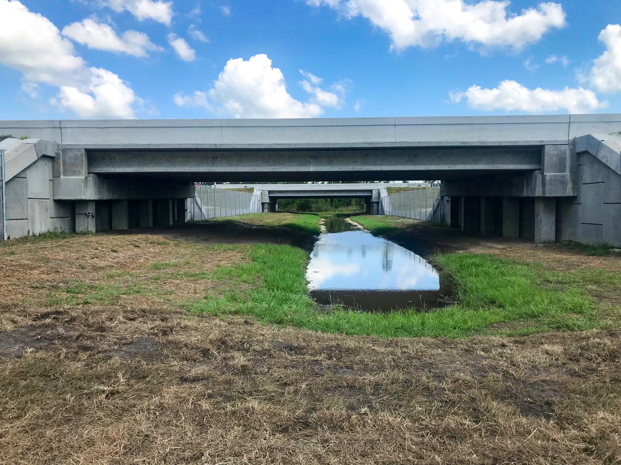
The I-4 at SR 557 crossing is located within the Florida Wildlife Corridor, a state-recognized conservation network that links protected lands across the state. This location connects parcels from the Avon Park Bombing Range, through the Hilochee Wildlife Management Area, and northward to the Green Swamp. With input from the Florida Department of Transportation (FDOT) and local stakeholders, the crossing was carefully positioned to maximize habitat value and speed up the construction timeline by nearly a decade.
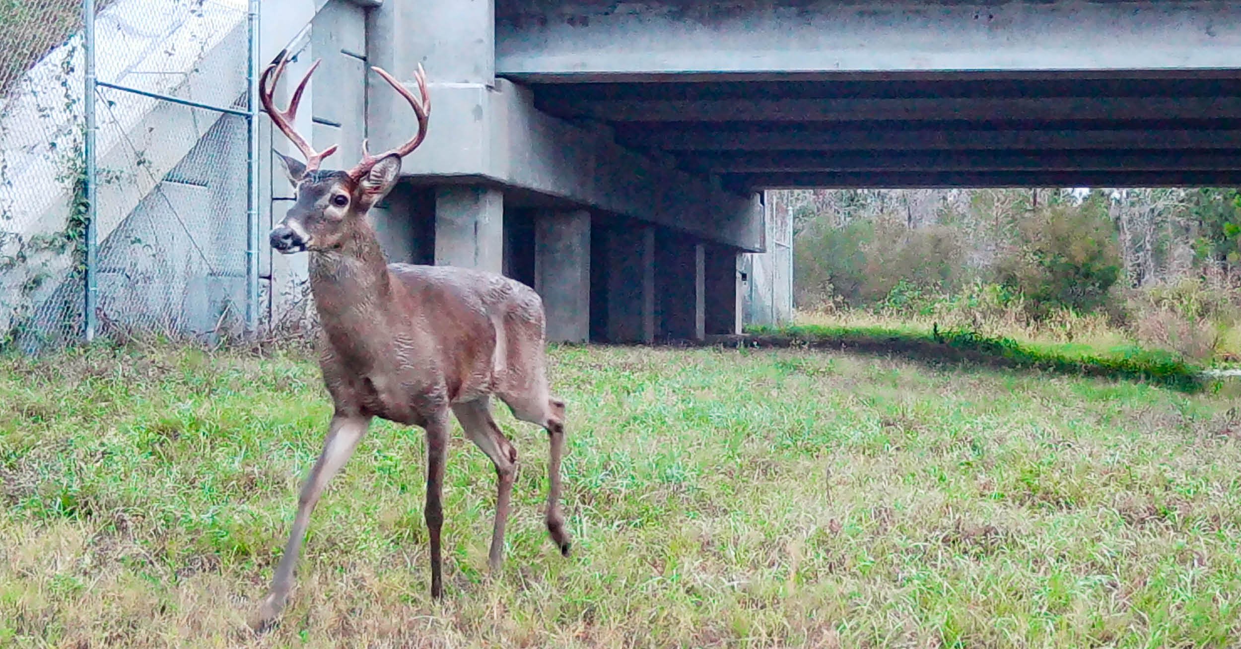
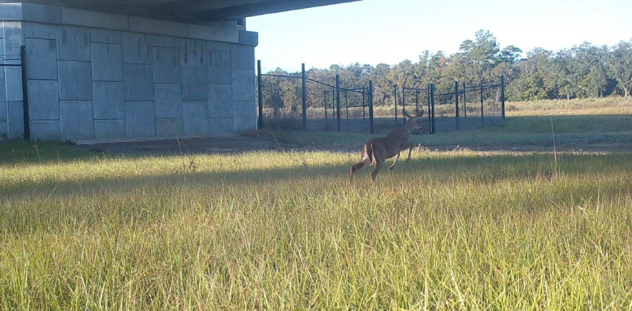
The structure itself was designed specifically for the species we were targeting, which were deer and the Florida Black Bear. We gave it 8 feet of vertical clearance, a 61-foot-wideopening, and a 67-foot total bridge span. We extended an existing 4x8-foot concrete box culvert to align with the new crossing and added a separate 5x5-foot culvert nearby to offer additional movement options for wildlife, particularly along an existing utility corridor. We also installed a 10-foot-high chain link fence that runs a full mile in each direction from the bridge, funneling animals safely toward the crossing. At the base of the fence, we used herpetological mesh to prevent small animals, such as frogs and snakes from slipping through, forcing them to use the crossing.
Wildlife On the Move
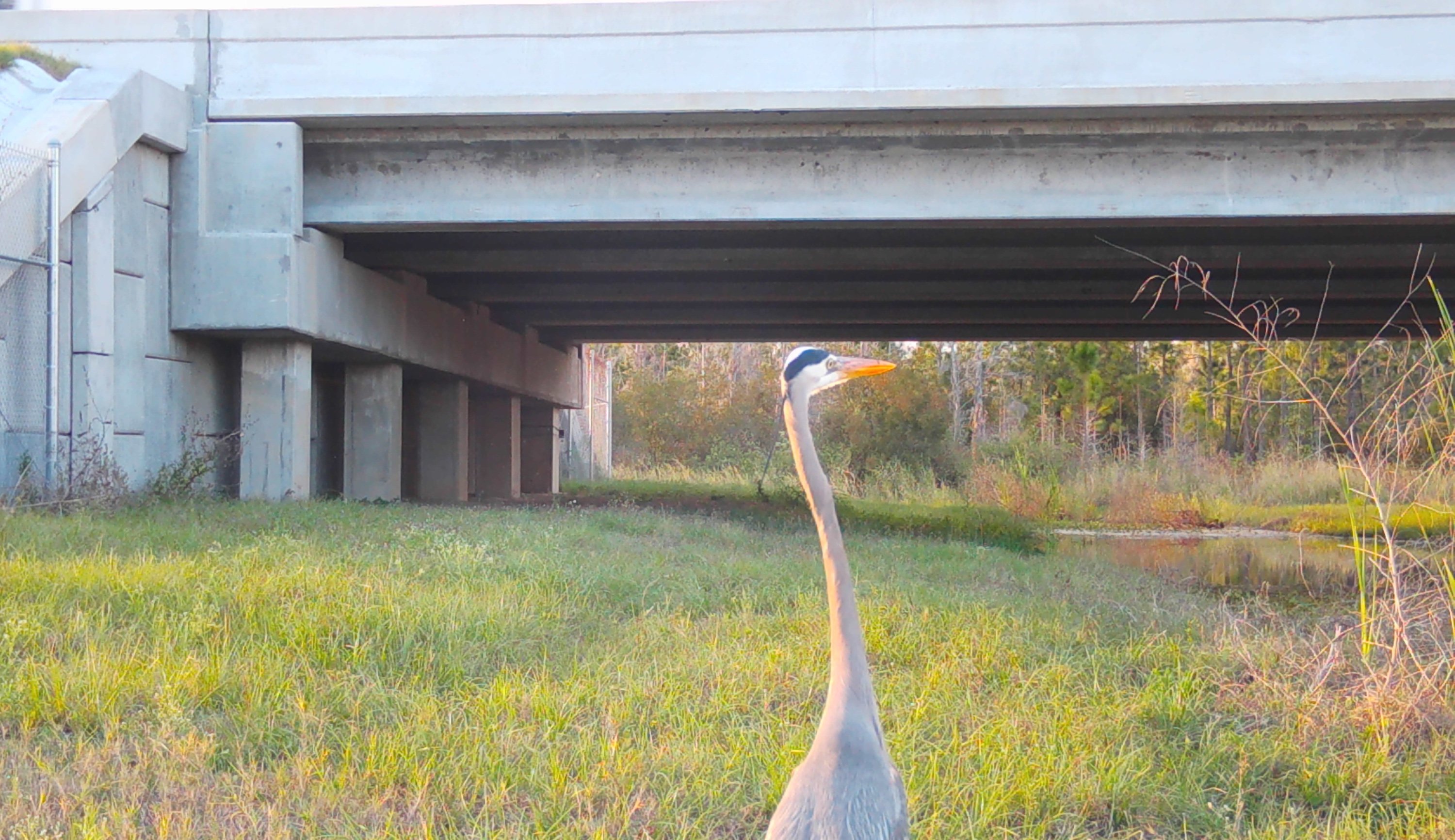
Monitoring cameras have already recorded successful use of the crossing by deer, raccoons, river otters, bobcats, and opossums. We’re optimistic that black bears will follow, and we’re holding out hope for panthers in the not-too-distant future.
Environmentally, we were also able to reduce mitigation costs by designing a swale feature that ties the crossing directly into existing wetlands on both sides of I-4. That wetland connection supports aquatic species, increases ecological functionality, and created mitigation credits that offset some of the unavoidable impacts from roadway improvements. These are the kinds of solutions we aim for – ones that serve ecological goals and client budgets.
Making a project like this possible requires major collaboration from the start. Engineers, ecologists, regulatory agencies, and community stakeholders all had a seat at the table. FDOT, to its credit, has developed an internal review process to assess potential for wildlife crossings on every new project, not because they’re federally required to, but because they believe in the value of protecting Florida’s wildlife.
Wildlife crossings change the game. They protect animals, reduce accidents, and prove that infrastructure can co-exist with nature instead of working against it. It’s encouraging to see growing recognition among decision-makers of just how essential these crossings have become.

George McLatchey, PWS, CEP, is a DRMP Vice President and Environmental Services Division Manager.
Posted in the categories All, Ecological Services, Project Development & Environment , Transportation, Transportation Planning/Project Development .
Related Articles
 Aug21Hurricane Milton Bridge Failure Demonstrates DRMP’s Rapid Emergency Response Expertise As we enter the peak of hurricane season...See Details
 Aug13Understanding Traffic Impact Analysis for Smarter DevelopmentBefore breaking ground on a project, it�...See Details
 Aug8How DRMP’s Teams in The Carolinas are Elevating Business Development to Better Serve ClientsAs DRMP continues to expand its services...See Details
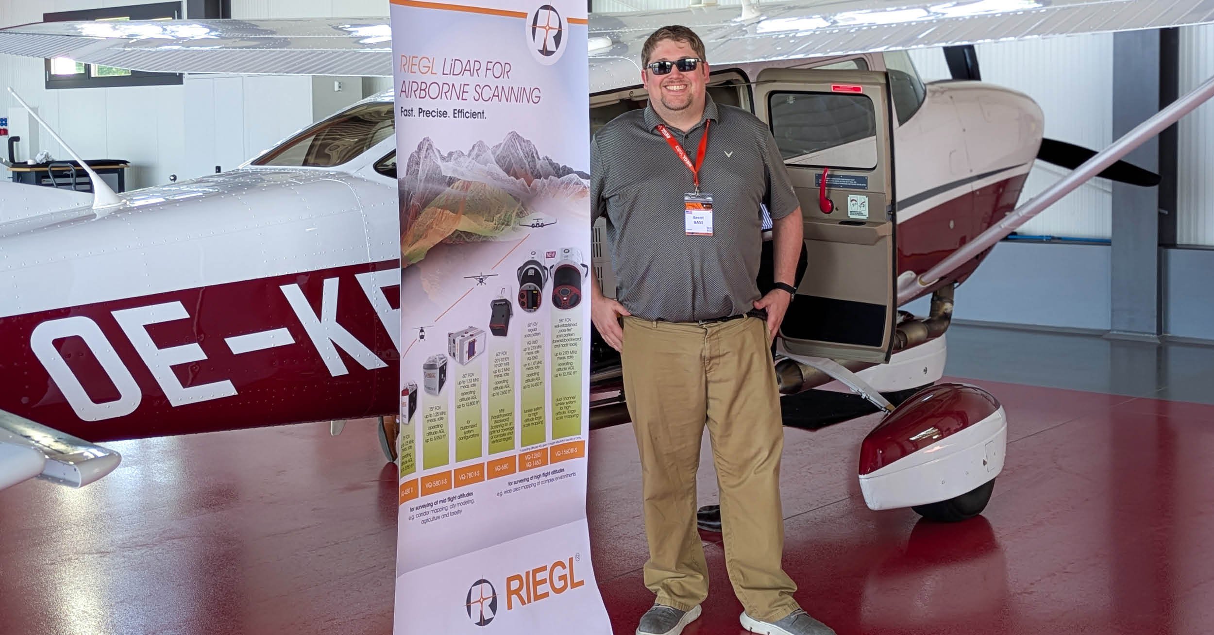 Aug6Exploring RIEGL’s Latest LiDAR Technologies at the VIP Customer Summit in AustriaDRMP Geospatial Services Division Manage...See Details

Categories
- All
- Alternative Delivery
- Civil Services
- Construction Services
- Disaster Resilience and Sustainability
- DRMPCares
- Ecological Services
- Electrical Engineering
- eWIRE
- Federal Services
- Geographic Information Systems
- Hurricane
- Land Development
- Learning & Development
- NEPA
- Project Development & Environment
- Structural Engineering
- Subsurface Utility Engineering
- Surveying & Mapping
- Traffic Impact Analysis
- Transportation
- Transportation Planning/Project Development
- Utilities Engineering
- Water Resources/Stormwater Management
Contributors
- Michael K. Albano, PE
- Bruno J. Arriola, PE, ENV SP
- Brent Bass, PE, PSM
- Cody Bayer, PE
- Maria Bazemore, PWS, AICP
- Paul Benvie, PE
- Donald W. Brown, PE
- Kyle Brown, PE
- Jake Burton
- Zach J. Carnahan, PE
- Brian Crowl, PE
- Patrick Day, PE
- Nick DeVito, PE
- Matt Floyd, PSM
- Deshon M. Fox, PE
- Scott Garth, PE, LEED AP ND
- Ryan M. Grab, CST II
- Robyn Hartz, INCE
- Justin Hayes, EI
- Lucas S. Helms, PE
- Jim Highland, PE
- Ryan Ianacone, CST II
- David Johnson, PE
- TJ Lallathin, Jr., PE, DBIA
- Jay McInnis, PE, CPM
- George McLatchey, PWS, CEP
- Michael McNeese
- Ryan Mitchell, PE
- Megan E. Mott, PE
- Josh Norman
- Melissa Padilla Cintron, SIT
- Pavan Paiavula, PE
- Ryan Pellarin, PE, CCM
- AJ Perkinson, PLS
- Julian Poole, PE
- Joce Pritchett, PE
- Leo Rodriguez, PE
- John Schick
- Rachel L. Schmidt, PWS
- Logan Shappell
- Rynal Stephenson, PE
- Deston Taylor, PE, PTOE
- August Thick II, PLS, CST III
- Orville Williams
- Amanda E. Woods, PE


