- Discover
-
Expertise
-
Alternative Delivery
- I-275 at I-4 Downtown Tampa Interchange Design-Build
- Wekiva Parkway Section 8 Interchange
- US 17/92 Interchange at SR 436
- SR 9B Extension from I-95 to US 1
- A. Max Brewer Bridge Replacement
- I-95 Widening from the Indian River/Brevard County Line to Malabar Road
- SR 528 (Beachline Expressway) at Innovation Way Interchange
- SR 570 Polk Parkway Widening from I-4 to Pace Road
- I-95 Express Lanes and Ramp Signals – Phase 3A-1
- Pollard Road Extension over Peace Creek
- I-485 Widening from I-77 to Rea Road
- Monroe Bypass/Connector Design-Build
- Construction Services
- Ecological Services
-
Federal Services
- Range of the Future Study
- US Coast Guard Air Station (Clearwater)
- Ascension Island Fire Station Renovation
- Patrick Space Force Base Water Lines Repair
- Patrick Space Force Base Living Shoreline Restoration
- P-505 Electrical Hardening and Black Start CHP at Marine Corps Air Station Beaufort
- Naval Station at Guantanamo Bay Survey Services
- Repair Phillips Parkway and Speed Limit Study
- Ascension Island Auxiliary Airfield Surveying and Mapping Services
-
Geographic Information Systems (GIS)
- Thermal Design/Comprehensive Campus LiDAR Collection
- Greater Orlando Aviation Authority (GOAA) Strategic Commerical Land Development Program
- University of Florida Sanitary Sewer GIS Mapping
- Ascension Island Auxiliary Airfield GIS Integration
- Santa Rosa County School District's School Transportation & Capacity GIS Analysis
- Gainesville Community Redevelopment Agency Socioeconomic Analysis and Site Suitability Report
- Real Estate Site Suitability and Development Analysis
- SR 836 (Dolphin Expressway) GIS Asset Inventory of Pre-Post Construction
- Alachua County Public Schools GIS and School Planning Professional Services
- Patrick Space Force Base Living Shoreline Restoration GIS Analysis
- Florida Army National Guard Readiness Center GIS Inventory & Integration
- Comprehensive Transit Study Puerto Rico GIS Analysis
- Land Development
- Structural Engineering
-
Subsurface Utility Engineering (SUE)
- Thermal Design/Comprehensive Campus LiDAR Collection
- P-505 Electrical Hardening and Black Start CHP at Marine Corps Air Station Beaufort
- Resurface & Safety Improvements Turnpike Mainline
- University of Florida Rabon Utility Mapping
- FP&L Subsurface Utility Engineering Continuing On-Call Contract
- Lockheed Martin Subsurface Utility Engineering Services
- Palm Coast Parkway Subsurface Utility Engineering Services
- Surveying & Mapping/Geospatial
-
Traffic Impact Analysis
- 505 West Chapel Hill Street
- 5th Street Station
- Beale Farm Industrial Park
- Blue Mountain Mist Resort
- The Villages at McCullers Walk
- Fredericksburg National Baseball Stadium
- Hendrick Southpoint Auto Mall
- Apex Friendship Elementary School
- Whole Foods Center
- Barclay West
- Grove 98
- Pullen Drive Extension/Catholic Diocese
- Trails/Parks & Recreation Facilities
- Transportation
-
Utilities Engineering
- Ascension Island Fire Station Renovation
- M-1 Canal Water Main Extension
- 5th Street Bridge Utility Replacement
- Captain’s Cove Wastewater Plant Revisions & Permit Renewal
- City of Fort Myers Downtown Utility & Streetscape Improvement
- Florida Caverns State Park Lift Station Rehab
- Tween Waters Inn Wastewater Plant Permit Renewal
- City of Fort Myers Wastewater Capacity Studies
- Patrick Space Force Base Water Lines Repair
- Big Lagoon Boat Ramp Wastewater System
- St. Joseph State Park Septic Tank Replacement
- WildBlue Development Wastewater Modeling
- A-1 Gator Wastewater Capacity Increase
- Visualization Services
- Water Resources/Stormwater Management
-
Alternative Delivery
- Careers
- News
- #DRMPerspective
- Team With Us
- Locations
« Back
DRMP Evaluates Critical Stormwater Pipes in West Central Florida to Enhance Infrastructure Resilience
May 8th, 2024
Florida's warm climate and geography make it a hotbed for powerful thunderstorms, tropical storms, and hurricanes, highlighting the importance of maintaining the state's drainage infrastructure. This infrastructure, crucial for flood control and ensuring the integrity of roadways, must be kept up to par.
In Hillsborough County, Fla., DRMP has taken the lead as the prime consultant for a condition assessment of the county’s critical stormwater pipes. Together, with subconsultants AREHNA Engineering, Inc., and Keystone Civil, Inc., we are inspecting more than 860 pipes.
The Hillsborough County Public Works Department plans to conduct regular inspections of the pipes to document their condition for reporting and planning purposes. Most of the pipes are showing signs of aging, especially corrugated metal pipes (CMP).
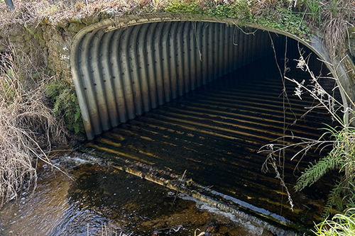
DRMP’s stormwater engineers and Geographic Information Systems (GIS) experts are working together to streamline this ambitious project.
As the Project Manager, I have been entrusted with ensuring the progression and ultimate success of this project over the course of seven months.
Assessing the Pipes
Within the County’s infrastructure are more than 100,000 stormwater pipes that require routine maintenance to ensure the system’s integrity. Among these, the County has singled out more than 1,700 pipes for inspection by two consultant firms.
DRMP’s focus is on visually inspecting 864 pipes – what the County has identified as “critical” pipes – primarily larger pipes over 30 years old. These pipes pose a greater risk to infrastructure and public safety, so it’s imperative they are routinely inspected.
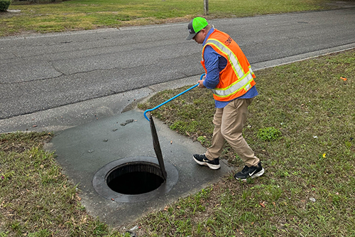
The DRMP team has been assessing the pipes using a score sheet (risk calculator) provided by the County. Our preliminary inspection revealed that most pipes were operational and seemed to fulfill their designated stormwater functions; however, with noticeable signs of aging. We proposed the County persist in evaluating the pipes' condition every three years and devise a work program to uphold and enhance their functionality, as necessary.
Furthermore, it is vital for the County to consistently allocate resources for the ongoing maintenance of these pipes, given their importance in flood control and preserving the integrity of roadways.
Streamlining the Process Using GIS
To enhance the efficiency of inspecting numerous culvert locations, we created a GIS field collection system. Using the County’s GIS map of pipe locations, we converted the data to a GIS database, which allowed DRMP to load the map into ESRI software “Field Maps” for use by field inspectors on tablets and mobile phones.
Using input values from the County's Risk Calculator, we created a comprehensive schema for the point layer, encompassing data fields for input values alongside five intermediate and final output scores.
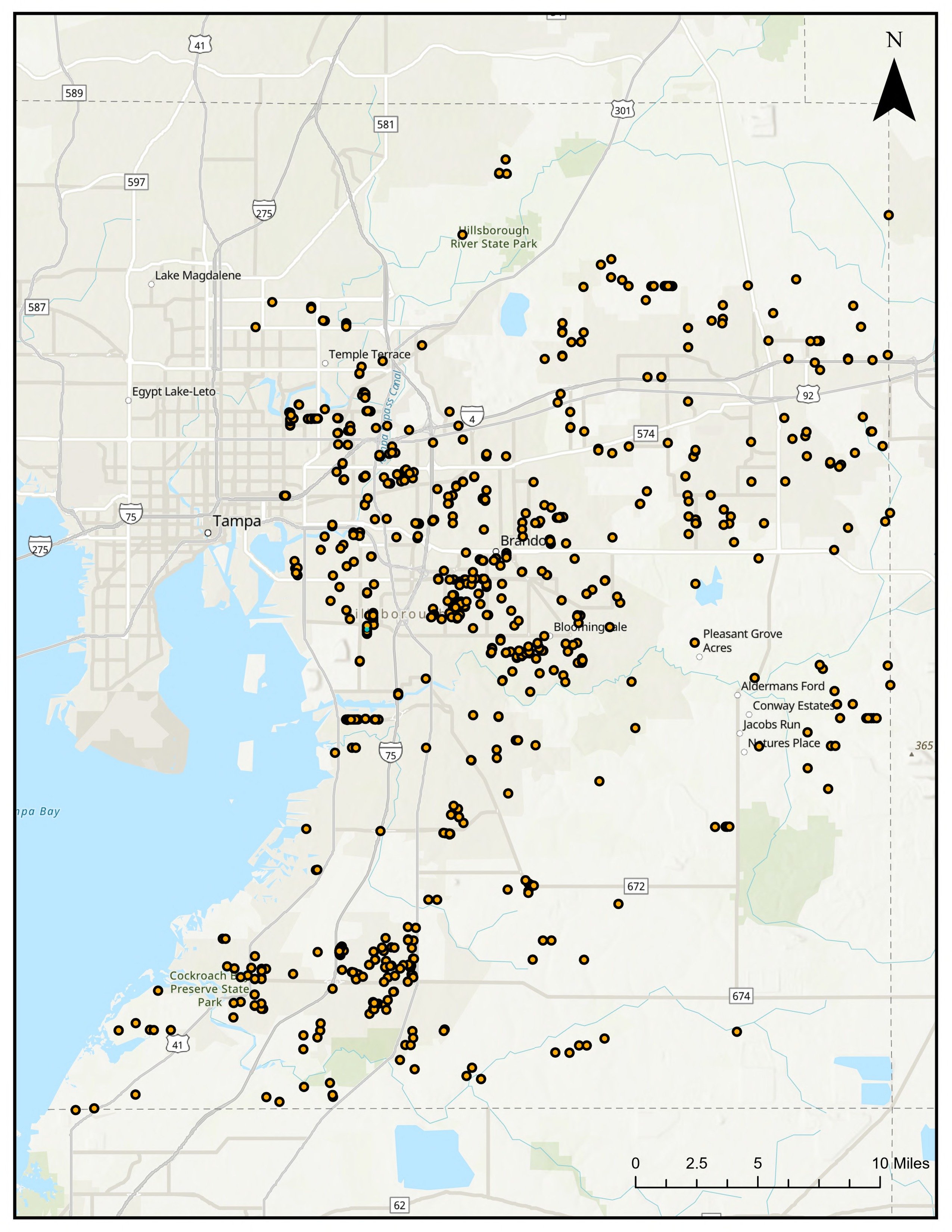
Equipped with GPS functionality, these devices enabled us to quickly identify the inspection points, allowing for the prompt recording of observations and the attachment of relevant photos to each record. Furthermore, the adoption of colored symbology for the map's points enhanced visual interpretation and analysis.
Our GIS team worked to develop data sheets that show each individual pipe inspected along with data attributes and photos collected in the field on a one-page PDF. The final product will consist of a booklet of the PDF sheets that detail the information gathered for each pipe.
To maintain records and ensure continuity of station data, we advised the County to gather and archive all culvert inspection data within a GIS/asset management database. This approach will enable County personnel to promptly access essential culvert details.
Using smart technology, such as GIS makes projects like this quicker and more efficient. This means we can spot issues and plan fixes faster.
By working together and staying proactive, we are building a stronger, more resilient, and sustainable future for our clients. Let’s keep investing in our infrastructure to keep our communities safe and thriving.
Scott Garth, PE, LEED AP ND, is a DRMP Vice President and Tampa Office Leader.
Posted in the categories All, Water Resources/Stormwater Management .
Related Articles
- Oct29Survey and SUE Expertise Pave the Way for North Carolina US 601 Widening ProjectFor the US 601 Widening Project, a cruci...See Details
- Oct17Construction Services Provide Critical Role in North Carolina’s I-40 Widening DRMP is honored to be a key player in co...See Details
- Oct16Hitting the Road with Mobile LiDAR, Amplifying Our ReachDRMP is advancing its Terrestrial Mobile...See Details
- Oct15Chasing Storms to Collect Critical Data for Drainage Projects Scott Garth, PE, LEED AP ND, recently ve...See Details
Categories
- All
- Alternative Delivery
- Construction Services
- Disaster Resilience and Sustainability
- Ecological Services
- Federal Services
- Geographic Information Systems
- Land Development
- NEPA
- Project Development & Environment
- Structural Engineering
- Subsurface Utility Engineering
- Surveying & Mapping
- Traffic Impact Analysis
- Transportation
- Transportation Planning/Project Development
- Utilities Engineering
- Water Resources/Stormwater Management
Contributors
- Michael K. Albano, PE
- Bruno J. Arriola, PE, ENV SP
- Brent Bass, PE, PSM
- Cody Bayer, PE
- Donald W. Brown, PE
- Kyle Brown, PE
- Zach J. Carnahan, PE
- Brian Crowl, PE
- Patrick Day, PE
- Nick DeVito, PE
- Matt Floyd, PSM
- Deshon M. Fox, PE
- Scott Garth, PE, LEED AP ND
- Ryan M. Grab, CST II
- Robyn Hartz
- Jim Highland, PE
- TJ Lallathin, Jr., PE, DBIA
- Kelly Marton, GISP
- Meaghan McCarthy
- Jay McInnis, PE, CPM
- George McLatchey, PWS, CEP
- Michael McNeese
- Jeff Miller
- Ryan Mitchell, PE
- Lisa Moon, PE
- Megan E. Mott, PE
- Josh Norman
- Melissa Padilla Cintron, SIT
- Pavan Paiavula, PE
- Julian Poole, PE
- Joce Pritchett, PE
- Abby Rains
- Leo Rodriguez, PE
- Rachel L. Schmidt, PWS
- Logan Shappell
- Brian V. Smith
- Rynal Stephenson, PE
- Deston Taylor, EI
- August Thick II, PLS, CST III
- Steven L. Wallace, PE
- Orville Williams
- Amanda E. Woods, PE
Recent Articles
- 10/29/24Survey and SUE Expertise Pave the Way for North Carolina US 601 Widening Project
- 10/17/24Construction Services Provide Critical Role in North Carolina’s I-40 Widening
- 10/16/24Hitting the Road with Mobile LiDAR, Amplifying Our Reach
- 10/15/24Chasing Storms to Collect Critical Data for Drainage Projects