- Discover
-
Expertise
-
Alternative Delivery
- I-275 at I-4 Downtown Tampa Interchange Design-Build
- Wekiva Parkway Section 8 Interchange
- US 17/92 Interchange at SR 436
- SR 9B Extension from I-95 to US 1
- A. Max Brewer Bridge Replacement
- I-95 Widening from the Indian River/Brevard County Line to Malabar Road
- SR 528 (Beachline Expressway) at Innovation Way Interchange
- SR 570 Polk Parkway Widening from I-4 to Pace Road
- I-95 Express Lanes and Ramp Signals – Phase 3A-1
- Pollard Road Extension over Peace Creek
- I-485 Widening from I-77 to Rea Road
- Monroe Bypass/Connector Design-Build
- Construction Services
- Ecological Services
-
Federal Services
- Range of the Future Study
- US Coast Guard Air Station (Clearwater)
- Ascension Island Fire Station Renovation
- Patrick Space Force Base Water Lines Repair
- Patrick Space Force Base Living Shoreline Restoration
- P-505 Electrical Hardening and Black Start CHP at Marine Corps Air Station Beaufort
- Naval Station at Guantanamo Bay Survey Services
- Repair Phillips Parkway and Speed Limit Study
- Ascension Island Auxiliary Airfield Surveying and Mapping Services
-
Geographic Information Systems (GIS)
- Thermal Design/Comprehensive Campus LiDAR Collection
- Greater Orlando Aviation Authority (GOAA) Strategic Commerical Land Development Program
- University of Florida Sanitary Sewer GIS Mapping
- Ascension Island Auxiliary Airfield GIS Integration
- Santa Rosa County School District's School Transportation & Capacity GIS Analysis
- Gainesville Community Redevelopment Agency Socioeconomic Analysis and Site Suitability Report
- Real Estate Site Suitability and Development Analysis
- SR 836 (Dolphin Expressway) GIS Asset Inventory of Pre-Post Construction
- Alachua County Public Schools GIS and School Planning Professional Services
- Patrick Space Force Base Living Shoreline Restoration GIS Analysis
- Florida Army National Guard Readiness Center GIS Inventory & Integration
- Comprehensive Transit Study Puerto Rico GIS Analysis
- Land Development
- Structural Engineering
-
Subsurface Utility Engineering (SUE)
- Thermal Design/Comprehensive Campus LiDAR Collection
- P-505 Electrical Hardening and Black Start CHP at Marine Corps Air Station Beaufort
- Resurface & Safety Improvements Turnpike Mainline
- University of Florida Rabon Utility Mapping
- FP&L Subsurface Utility Engineering Continuing On-Call Contract
- Lockheed Martin Subsurface Utility Engineering Services
- Palm Coast Parkway Subsurface Utility Engineering Services
- Surveying & Mapping/Geospatial
-
Traffic Impact Analysis
- 505 West Chapel Hill Street
- 5th Street Station
- Beale Farm Industrial Park
- Blue Mountain Mist Resort
- The Villages at McCullers Walk
- Fredericksburg National Baseball Stadium
- Hendrick Southpoint Auto Mall
- Apex Friendship Elementary School
- Whole Foods Center
- Barclay West
- Grove 98
- Pullen Drive Extension/Catholic Diocese
- Trails/Parks & Recreation Facilities
- Transportation
-
Utilities Engineering
- Ascension Island Fire Station Renovation
- M-1 Canal Water Main Extension
- 5th Street Bridge Utility Replacement
- Captain’s Cove Wastewater Plant Revisions & Permit Renewal
- City of Fort Myers Downtown Utility & Streetscape Improvement
- Florida Caverns State Park Lift Station Rehab
- Tween Waters Inn Wastewater Plant Permit Renewal
- City of Fort Myers Wastewater Capacity Studies
- Patrick Space Force Base Water Lines Repair
- Big Lagoon Boat Ramp Wastewater System
- St. Joseph State Park Septic Tank Replacement
- WildBlue Development Wastewater Modeling
- A-1 Gator Wastewater Capacity Increase
- Water Resources/Stormwater Management
-
Alternative Delivery
- Careers
- News
- #DRMPerspective
- Team With Us
- Locations

Chasing Storms: Going the Extra Mile to Capture Real-Time Stormwater Data for Drainage Projects
October 15th, 2024


As stormwater engineers, one of our key responsibilities is to manage runoff and provide for water quality improvements where practical. We strive to improve the quality of life for the public by improving infrastructure.
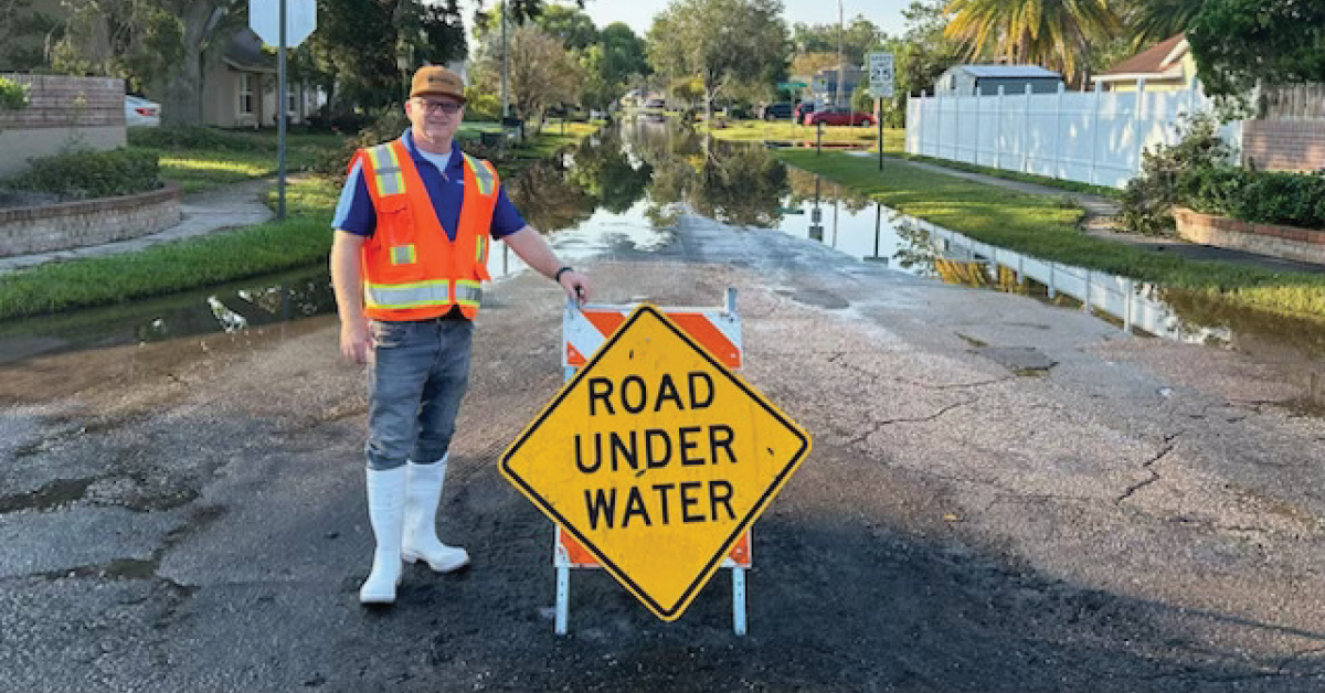
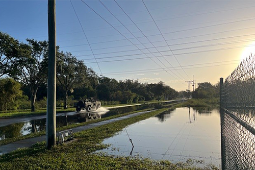
Recently, I was out in flood-affected neighborhoods visiting homes and other areas to document conditions for ongoing municipal and Florida Department of Transportation projects.
These opportunities, although challenging, allow us to capture real-world data that informs how we solve flooding. Flooded areas are often difficult to access, especially in urban settings or areas with damaged infrastructure, such as roads and bridges. This can delay data collection or prevent access to critical points entirely. Flooded areas can also be dangerous, with fast-moving water, unstable ground, and submerged hazards, such as debris, which can make data collection risky for field engineers and inspectors.
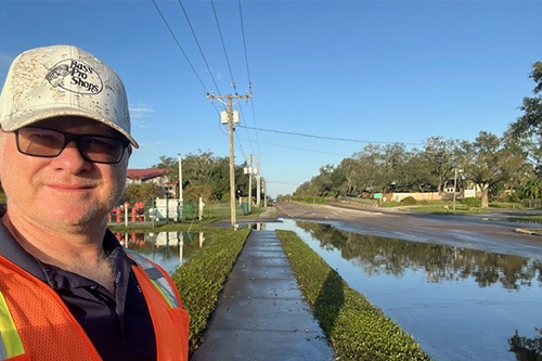
I consider myself a bit of a storm chaser. When significant rainfall events hit—like Tropical Storm Debby and hurricanes Helene and Milton —I make it a point to document flooding conditions firsthand as much as possible. This information is invaluable when designing solutions for neighborhoods and other areas that regularly experience flooding.
We often know there’s an issue, but without accurate records, we don’t always know the full extent of the flooding. Typically, the city, county, and department of transportation maintenance teams provide this data that helps us understand the problem and to design drainage systems to better manage stormwater. However, fieldwork allows me to personally pinpoint what’s causing the flooding, whether it’s undersized pipes, poorly graded roadways, or a tailwater system that isn’t draining effectively. Interviewing nearby residents and businesses can also be very helpful in determining the duration, frequency, and extent of the flooding.
Getting Calculations Right Can Save Lives
I conduct storm reconnaissance both during and after storms, though primarily once it’s safe to do so. Observing the aftermath often provides a clearer picture because we are not designing drainage or roadway systems to handle extreme events, such as 100-year storms—unless it's for something critical, like an emergency access road or an evacuation route. For local residential roads, drainage systems are usually designed for lesser storm events.
Depending on the project, I’ll assess conditions during the rain itself, but sometimes I wait, especially when creek systems lag in when they crest or reach peak stage. It can take several hours or even days for rivers or creeks to reach their peak levels.
If I need to document hydroplaning risks, I’ll do it during the rain. Seeing these issues firsthand brings a project to life and adds meaning to the work, knowing we are making communities safer for the public. It’s also personal to me—my brother hydroplaned on I-75 in Tampa, and it could have cost him his life. That's why getting hydroplaning calculations right is crucial in designing safer roadways.
Designing for Resilience and the Future
Additionally, when we model drainage systems, we must think long-term. In coastal areas, sea level rise is a critical factor, especially as we’re seeing a rise in extreme weather events resulting from climate change. Without accounting for future conditions, projects designed today could be undersized in just a few decades, which is why many coastal regions now require us to incorporate sea level rise into our designs.
This hands-on approach stems from my background working for the Florida Department of Transportation as a Drainage Engineer where I also served on its State Emergency Response Team (SERT) assessing storm damage and investigating flooding complaints.
It’s become second nature to conduct thorough, rain-soaked field reviews for any project I’m working on. While some newer engineers may rely on satellite imagery, I have found that nothing compares to being out in the field and seeing the conditions for myself. I share my knowledge with DRMP’s young drainage engineers to show them the value of firsthand experience and to encourage them to prioritize field reviews.
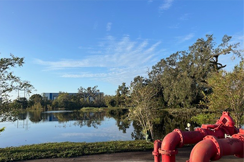
Some of the innovative stormwater best management practices (BMP’s) that we have incorporated have included backflow prevention devices, CDS units, denitrification walls, and stormwater pumping stations.
Ultimately, these storm events aren’t just data points—they're reminders of the importance of designing systems that protect communities. This work directly impacts people’s safety, and knowing that, makes every field review, every storm-chasing excursion, feel worth it.
Related Articles
 Sep10DRMP’s Learning Culture Sets the Standard for the A/E/C IndustryInvesting in the next generation of engi...See Details
 Sep10DRMP Provides All the Right Ingredients for a Fulfilling Career Employees at DRMP get the full package �...See Details
 Sep8DRMP Contracts with HGACBuy to Streamline Disaster Recovery ServicesDRMP has contracted with HGACBuy to assi...See Details
 Sep4DRMP’s Wildlife Crossing Expertise Protects Florida’s Ecosystems, Public Safety, and Endangered SpeciesAs we celebrate National Wildlife Day, a...See Details

Categories
- All
- Alternative Delivery
- Civil Services
- Construction Services
- Disaster Resilience and Sustainability
- DRMPCares
- Ecological Services
- Electrical Engineering
- eWIRE
- Federal Services
- Geographic Information Systems
- Hurricane
- Land Development
- Learning & Development
- NEPA
- Project Development & Environment
- Structural Engineering
- Subsurface Utility Engineering
- Surveying & Mapping
- Traffic Impact Analysis
- Transportation
- Transportation Planning/Project Development
- Utilities Engineering
- Water Resources/Stormwater Management
Contributors
- Michael K. Albano, PE
- Bruno J. Arriola, PE, ENV SP
- Brent Bass, PE, PSM
- Cody Bayer, PE
- Maria Bazemore, PWS, AICP
- Paul Benvie, PE
- Donald W. Brown, PE
- Kyle Brown, PE
- Jake Burton
- Zach J. Carnahan, PE
- Brian Crowl, PE
- Patrick Day, PE
- Nick DeVito, PE
- Matt Floyd, PSM
- Deshon M. Fox, PE
- Scott Garth, PE, LEED AP ND
- Ryan M. Grab, CST II
- Robyn Hartz, INCE
- Justin Hayes, EI
- Lucas S. Helms, PE
- Jim Highland, PE
- Ryan Ianacone, CST II
- David Johnson, PE
- TJ Lallathin, Jr., PE, DBIA
- Jay McInnis, PE, CPM
- George McLatchey, PWS, CEP
- Michael McNeese
- Ryan Mitchell, PE
- Megan E. Mott, PE
- Josh Norman
- Melissa Padilla Cintron, SIT
- Pavan Paiavula, PE
- Ryan Pellarin, PE, CCM
- AJ Perkinson, PLS
- Julian Poole, PE
- Joce Pritchett, PE
- Leo Rodriguez, PE
- John Schick
- Rachel L. Schmidt, PWS
- Logan Shappell
- Rynal Stephenson, PE
- Deston Taylor, PE, PTOE
- August Thick II, PLS, CST III
- Orville Williams
- Amanda E. Woods, PE
Recent Articles
- 09/10/25DRMP’s Learning Culture Sets the Standard for the A/E/C Industry
- 09/10/25DRMP Provides All the Right Ingredients for a Fulfilling Career
- 09/8/25DRMP Contracts with HGACBuy to Streamline Disaster Recovery Services
- 09/4/25DRMP’s Wildlife Crossing Expertise Protects Florida’s Ecosystems, Public Safety, and Endangered Species


