- Discover
-
Expertise
-
Alternative Delivery
- I-275 at I-4 Downtown Tampa Interchange Design-Build
- Wekiva Parkway Section 8 Interchange
- US 17/92 Interchange at SR 436
- SR 9B Extension from I-95 to US 1
- A. Max Brewer Bridge Replacement
- I-95 Widening from the Indian River/Brevard County Line to Malabar Road
- SR 528 (Beachline Expressway) at Innovation Way Interchange
- SR 570 Polk Parkway Widening from I-4 to Pace Road
- I-95 Express Lanes and Ramp Signals – Phase 3A-1
- Pollard Road Extension over Peace Creek
- I-485 Widening from I-77 to Rea Road
- Monroe Bypass/Connector Design-Build
- Construction Services
- Ecological Services
-
Federal Services
- Range of the Future Study
- US Coast Guard Air Station (Clearwater)
- Ascension Island Fire Station Renovation
- Patrick Space Force Base Water Lines Repair
- Patrick Space Force Base Living Shoreline Restoration
- P-505 Electrical Hardening and Black Start CHP at Marine Corps Air Station Beaufort
- Naval Station at Guantanamo Bay Survey Services
- Repair Phillips Parkway and Speed Limit Study
- Ascension Island Auxiliary Airfield Surveying and Mapping Services
-
Geographic Information Systems (GIS)
- Thermal Design/Comprehensive Campus LiDAR Collection
- Greater Orlando Aviation Authority (GOAA) Strategic Commerical Land Development Program
- University of Florida Sanitary Sewer GIS Mapping
- Ascension Island Auxiliary Airfield GIS Integration
- Santa Rosa County School District's School Transportation & Capacity GIS Analysis
- Gainesville Community Redevelopment Agency Socioeconomic Analysis and Site Suitability Report
- Real Estate Site Suitability and Development Analysis
- SR 836 (Dolphin Expressway) GIS Asset Inventory of Pre-Post Construction
- Alachua County Public Schools GIS and School Planning Professional Services
- Patrick Space Force Base Living Shoreline Restoration GIS Analysis
- Florida Army National Guard Readiness Center GIS Inventory & Integration
- Comprehensive Transit Study Puerto Rico GIS Analysis
- Land Development
- Structural Engineering
-
Subsurface Utility Engineering (SUE)
- Thermal Design/Comprehensive Campus LiDAR Collection
- P-505 Electrical Hardening and Black Start CHP at Marine Corps Air Station Beaufort
- Resurface & Safety Improvements Turnpike Mainline
- University of Florida Rabon Utility Mapping
- FP&L Subsurface Utility Engineering Continuing On-Call Contract
- Lockheed Martin Subsurface Utility Engineering Services
- Palm Coast Parkway Subsurface Utility Engineering Services
- Surveying & Mapping/Geospatial
-
Traffic Impact Analysis
- 505 West Chapel Hill Street
- 5th Street Station
- Beale Farm Industrial Park
- Blue Mountain Mist Resort
- The Villages at McCullers Walk
- Fredericksburg National Baseball Stadium
- Hendrick Southpoint Auto Mall
- Apex Friendship Elementary School
- Whole Foods Center
- Barclay West
- Grove 98
- Pullen Drive Extension/Catholic Diocese
- Trails/Parks & Recreation Facilities
- Transportation
-
Utilities Engineering
- Ascension Island Fire Station Renovation
- M-1 Canal Water Main Extension
- 5th Street Bridge Utility Replacement
- Captain’s Cove Wastewater Plant Revisions & Permit Renewal
- City of Fort Myers Downtown Utility & Streetscape Improvement
- Florida Caverns State Park Lift Station Rehab
- Tween Waters Inn Wastewater Plant Permit Renewal
- City of Fort Myers Wastewater Capacity Studies
- Patrick Space Force Base Water Lines Repair
- Big Lagoon Boat Ramp Wastewater System
- St. Joseph State Park Septic Tank Replacement
- WildBlue Development Wastewater Modeling
- A-1 Gator Wastewater Capacity Increase
- Visualization Services
- Water Resources/Stormwater Management
-
Alternative Delivery
- Careers
- News
- #DRMPerspective
- Team With Us
- Locations
« Back
Modernizing Access: New Bridge Design Enhances Safety and Environment
February 14th, 2024
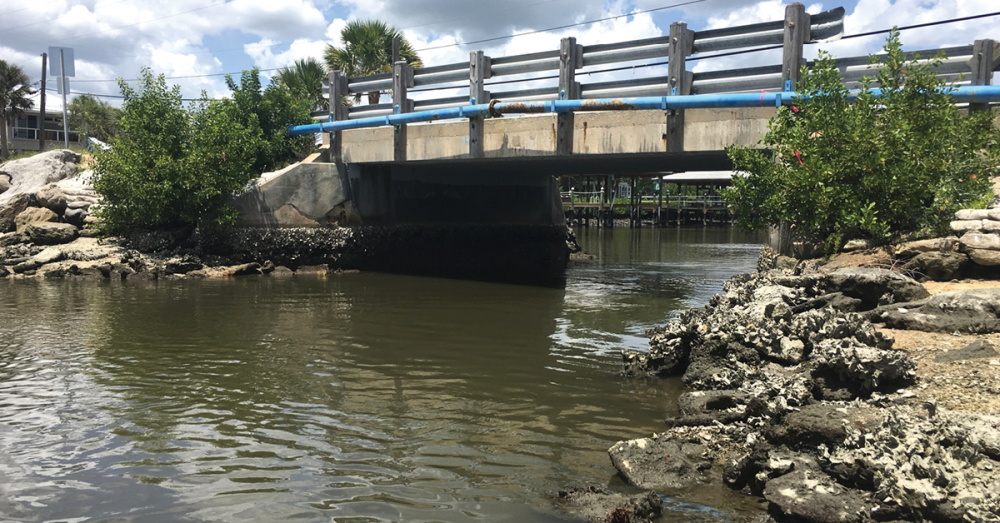
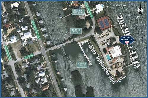
Located within the scenic Yacht Club Cut in New Smyrna Beach, Fla., is an aging bridge that provides critical accessibility.
The 5th Street Bridge, with one travel lane in each direction to accommodate two-way traffic, serves as the sole vehicle route connecting Riverside Drive to a quaint island enclave that is home to the historic Smyrna Yacht Club and 24 waterfront residences along Commodore Drive.
Since its construction in 1965, this single-span bridge has served the community, but time has taken its toll on the structure. With the bridge’s deteriorating conditions and the need to improve access and safety, the City of New Smyrna Beach selected DRMP as the prime consultant to design a replacement bridge. The new bridge design not only addresses current infrastructure challenges but also enhances the surrounding environment.
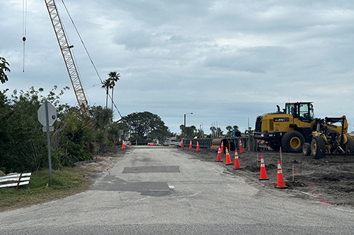
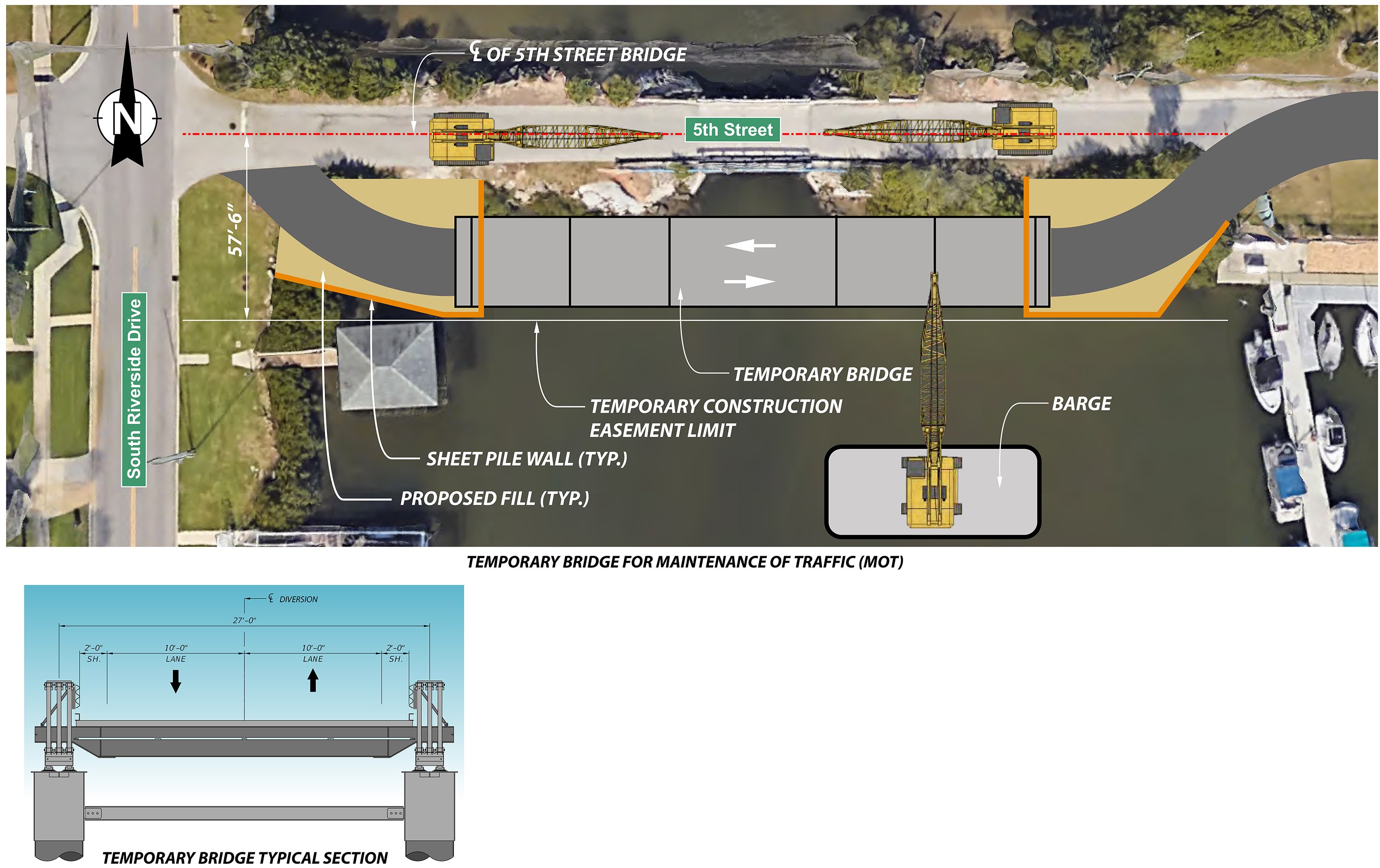
As the project manager, I am excited to report the considerable progress of this project since it launched in 2018. Design of the project began in 2018 and was completed in 2023 with construction beginning in fall 2023. Last month, the contractor, P&S Paving, installed a temporary steel bridge to the south of the existing bridge to provide access while the new bridge is being built. Currently the existing bridge is being demolished, and the new bridge construction is underway.
Safer Bridge with Environmental Benefits
The original bridge connecting to the yacht club is undergoing an upgrade with a new 160-foot, three-span bridge set to replace it. It will be constructed for a service life of 75 years. The more modern design provides two 9-foot-wide travel lanes and 2-foot-wide shoulders on the approaches on each side of the bridge and a 5-foot-wide sidewalk on the north side of the bridge, making it a safer structure than the original.
With delivery trucks making frequent trips to the yacht club, the new bridge design will allow for more room as cars travel side-by-side over the bridge. The addition of a sidewalk also makes it safer for pedestrians to cross the bridge.
One of the key benefits of this project is the incorporation of rubble riprap. This design involves the removal of several feet of existing embankment and the reconstruction of sloped abutments using rubble riprap.
By implementing sloped abutments at each end of the bridge, we aim to significantly mitigate the wash-out that occurred with the existing structure. The rubble riprap consists of large rocks, which will help reduce flow velocities within the channel at the end spans and protect the bridge long-term. Additionally, the reconstruction of both sides of the bridge approaches will not only ensure a smoother ride for commuters but also facilitate efficient water drainage further enhancing the bridge’s resilience.
Our new bridge design also will widen the channel through Yacht Club Cut and promote additional water flow under the bridge, while restoring water flows back to what they were prior to the construction of the original bridge in 1965. It is the hope that improving the water flows will attract natural species back to the area. We are also going to be raising the bridge over the channel approximately 2 feet, so there will be more than a 5-foot vertical clearance on average above the top of the water.
As part of the project, our firm’s Environmental Services Group conducted an environmental review to determine necessary steps to avoid minimizing or mitigating environmental impacts. Our firm designed a living shoreline and relocated oyster beds and mangroves in the project area to approximately 3 acres of wetlands to mitigate impacts associated with the bridge replacement.
Project Preparation
The first two to three months of this project involved prepping the site for the construction of a temporary bridge, which involved driving piles in the channel. The temporary bridge, located south of the existing bridge, will be in place for about a year and will have a speed limit of approximately 15 mph. Although these temporary bridges are typically used on highways with speeds of up to 65 mph, due to the specific area, the speed limit going over Yacht Club Cut will be posted at 15 mph.
The existing bridge supports various utilities on both sides, such as water, sewer, and gas lines, with overhead electric and cable situated adjacent to the north side.
DRMP was tasked with replacing these utilities, including water mains, sewer mains, electric, and communication cables. Employing directional drilling techniques, our team designed the utility infrastructure to minimize disruption by avoiding the need to relocate utilities twice, ensuring continuous service during both temporary and permanent bridge construction.
Our team carefully coordinated the directional drills to steer clear of bridge piling and keep them outside the bridge footprint. Project permitting involved obtaining a Sovereign Submerged Land Lease. Our expertise allowed the client to successfully modernize the affected utilities and manage any construction-related utility challenges.
The replacement of the 5th Street Bridge improves accessibility, safety, and environmental sustainability for the New Smyrna Beach community. Through innovative design, careful planning, and coordination, this project not only addresses infrastructure challenges but also promotes resilience and environmental stewardship. As construction progresses, we look forward to witnessing the positive impacts of this transformative project.
Amanda Woods, PE, serves as Senior Vice President/Director of Transportation for DRMP’s Transportation Market Sector.
Posted in the categories All, Structural Engineering, Transportation, Transportation Planning/Project Development , Utilities Engineering.
Related Articles
- Nov21Giving Buses a Head Start in Raleigh, N.C. Raleigh's bustling corridors can make it...See Details
- Nov20Celebrating National GIS Day 2024As we celebrate National GIS Day, DRMP�...See Details
- Nov6Ewire Featured Story: PDES Team Guides Projects for Federal Compliance and SuccessLed by an experienced and versatile grou...See Details
- Nov6Expertise Highlight: Combating Flooding in Underserved Arkansas Communities In many predominantly Black rural towns ...See Details
Categories
- All
- Alternative Delivery
- Construction Services
- Disaster Resilience and Sustainability
- DRMPCares
- Ecological Services
- Federal Services
- Geographic Information Systems
- Land Development
- NEPA
- Project Development & Environment
- Structural Engineering
- Subsurface Utility Engineering
- Surveying & Mapping
- Traffic Impact Analysis
- Transportation
- Transportation Planning/Project Development
- Utilities Engineering
- Water Resources/Stormwater Management
Contributors
- Michael K. Albano, PE
- Bruno J. Arriola, PE, ENV SP
- Brent Bass, PE, PSM
- Cody Bayer, PE
- Donald W. Brown, PE
- Kyle Brown, PE
- Zach J. Carnahan, PE
- Brian Crowl, PE
- Patrick Day, PE
- Nick DeVito, PE
- Matt Floyd, PSM
- Deshon M. Fox, PE
- Scott Garth, PE, LEED AP ND
- Ryan M. Grab, CST II
- Robyn Hartz
- Jim Highland, PE
- TJ Lallathin, Jr., PE, DBIA
- Kelly Marton, GISP
- Meaghan McCarthy
- Jay McInnis, PE, CPM
- George McLatchey, PWS, CEP
- Michael McNeese
- Jeff Miller
- Ryan Mitchell, PE
- Lisa Moon, PE
- Megan E. Mott, PE
- Josh Norman
- Melissa Padilla Cintron, SIT
- Pavan Paiavula, PE
- Julian Poole, PE
- Joce Pritchett, PE
- Abby Rains
- Leo Rodriguez, PE
- Rachel L. Schmidt, PWS
- Logan Shappell
- Brian V. Smith
- Rynal Stephenson, PE
- Deston Taylor, EI
- August Thick II, PLS, CST III
- Steven L. Wallace, PE
- Orville Williams
- Amanda E. Woods, PE
Recent Articles
- 11/21/24Giving Buses a Head Start in Raleigh, N.C.
- 11/20/24Celebrating National GIS Day 2024
- 11/6/24Ewire Featured Story: PDES Team Guides Projects for Federal Compliance and Success
- 11/6/24Expertise Highlight: Combating Flooding in Underserved Arkansas Communities
- 11/6/24 DRMP Employees Join Forces to Create Lasting Impact in Local Communities