- Discover
-
Expertise
-
Alternative Delivery
- I-275 at I-4 Downtown Tampa Interchange Design-Build
- Wekiva Parkway Section 8 Interchange
- US 17/92 Interchange at SR 436
- SR 9B Extension from I-95 to US 1
- A. Max Brewer Bridge Replacement
- I-95 Widening from the Indian River/Brevard County Line to Malabar Road
- SR 528 (Beachline Expressway) at Innovation Way Interchange
- SR 570 Polk Parkway Widening from I-4 to Pace Road
- I-95 Express Lanes and Ramp Signals – Phase 3A-1
- Pollard Road Extension over Peace Creek
- I-485 Widening from I-77 to Rea Road
- Monroe Bypass/Connector Design-Build
- Construction Services
- Ecological Services
-
Federal Services
- Range of the Future Study
- US Coast Guard Air Station (Clearwater)
- Ascension Island Fire Station Renovation
- Patrick Space Force Base Water Lines Repair
- Patrick Space Force Base Living Shoreline Restoration
- P-505 Electrical Hardening and Black Start CHP at Marine Corps Air Station Beaufort
- Naval Station at Guantanamo Bay Survey Services
- Repair Phillips Parkway and Speed Limit Study
- Ascension Island Auxiliary Airfield Surveying and Mapping Services
-
Geographic Information Systems (GIS)
- Thermal Design/Comprehensive Campus LiDAR Collection
- Greater Orlando Aviation Authority (GOAA) Strategic Commerical Land Development Program
- University of Florida Sanitary Sewer GIS Mapping
- Ascension Island Auxiliary Airfield GIS Integration
- Santa Rosa County School District's School Transportation & Capacity GIS Analysis
- Gainesville Community Redevelopment Agency Socioeconomic Analysis and Site Suitability Report
- Real Estate Site Suitability and Development Analysis
- SR 836 (Dolphin Expressway) GIS Asset Inventory of Pre-Post Construction
- Alachua County Public Schools GIS and School Planning Professional Services
- Patrick Space Force Base Living Shoreline Restoration GIS Analysis
- Florida Army National Guard Readiness Center GIS Inventory & Integration
- Comprehensive Transit Study Puerto Rico GIS Analysis
- Land Development
- Structural Engineering
-
Subsurface Utility Engineering (SUE)
- Thermal Design/Comprehensive Campus LiDAR Collection
- P-505 Electrical Hardening and Black Start CHP at Marine Corps Air Station Beaufort
- Resurface & Safety Improvements Turnpike Mainline
- University of Florida Rabon Utility Mapping
- FP&L Subsurface Utility Engineering Continuing On-Call Contract
- Lockheed Martin Subsurface Utility Engineering Services
- Palm Coast Parkway Subsurface Utility Engineering Services
- Surveying & Mapping/Geospatial
-
Traffic Impact Analysis
- 505 West Chapel Hill Street
- 5th Street Station
- Beale Farm Industrial Park
- Blue Mountain Mist Resort
- The Villages at McCullers Walk
- Fredericksburg National Baseball Stadium
- Hendrick Southpoint Auto Mall
- Apex Friendship Elementary School
- Whole Foods Center
- Barclay West
- Grove 98
- Pullen Drive Extension/Catholic Diocese
- Trails/Parks & Recreation Facilities
- Transportation
-
Utilities Engineering
- Ascension Island Fire Station Renovation
- M-1 Canal Water Main Extension
- 5th Street Bridge Utility Replacement
- Captain’s Cove Wastewater Plant Revisions & Permit Renewal
- City of Fort Myers Downtown Utility & Streetscape Improvement
- Florida Caverns State Park Lift Station Rehab
- Tween Waters Inn Wastewater Plant Permit Renewal
- City of Fort Myers Wastewater Capacity Studies
- Patrick Space Force Base Water Lines Repair
- Big Lagoon Boat Ramp Wastewater System
- St. Joseph State Park Septic Tank Replacement
- WildBlue Development Wastewater Modeling
- A-1 Gator Wastewater Capacity Increase
- Visualization Services
- Water Resources/Stormwater Management
-
Alternative Delivery
- Careers
- News
- #DRMPerspective
- Team With Us
- Locations
« Back
Guiding the Future of DeLand's Lake Moore Conservation Area
August 29th, 2024
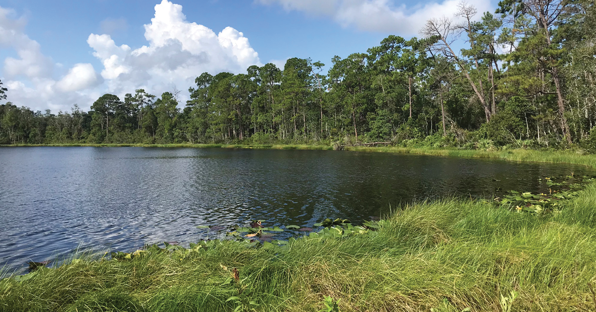
The City of DeLand, Fla., last year expanded its green spaces with the acquisition of the Lake Moore Conservation Area (LMCA), a 128-acre property near the city’s downtown previously owned by the Volusia Groves & Cattle Co. The procurement of LMCA by the City was part of the Volusia Forever Stewardship Program.
This new addition to the city's landscape is set to become a vital part of its conservation and recreational efforts. To bring this vision to life, the City entrusted DRMP to develop a property management plan, assess the land's environmental conditions, proposed use, and outline strategies for its future use and recreational improvements.
DRMP’s Environmental Services Group helps clients with environmental assessments, strategic management plans, and regulatory compliance for public lands. Our expertise ensures that projects like the Lake Moore Conservation Area are planned and managed to support conservation goals and recreational use while meeting legal requirements.
Featuring 2.64 miles of trails and approximately 0.14 miles of east Dr. Martin Luther King Jr. Boulevard and 0.5 miles west of County Road 4139 – LMCA offers opportunities for passive recreation and environmental preservation.
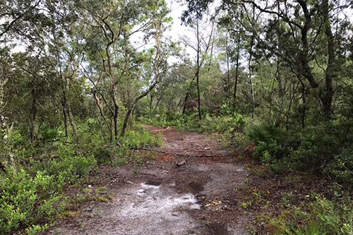
DRMP’s environmental assessment and property management plan aligns with the City’s objectives and management measures outlined in the LMCA’s Perpetual Conservation Easement. The Volusia County Commission approved the plan on Aug. 20, 2024.
We emphasized in the plan that all proposed developments and resource alterations will require appropriate permits and legal approvals. Approval of the management plan does not exempt the project from complying with local, state, or federal regulations.
Recreational Activities
The City is dedicated to offering passive recreational opportunities that require minimal infrastructure and land modification. These activities include hiking, walking, wildlife observation, birdwatching, non-motorized boating, and fishing. Our environmental assessment determined the proposed activities will not negatively impact drainage, flood control, water conservation, or wildlife habitats. All plans adhere to the Recreational Carrying Capacity Guidelines set by the Florida Department of Environmental Protection (FDEP). The LMCA will feature:
- Color-coded pedestrian dirt trails of varying lengths
- Scenic picnic areas
- Bear-proof trash cans near picnic spots
- Non-motorized boating access on Lake Moore for canoes and kayaks
- Educational kiosks and informational signage
- A trailhead providing visitor information about LMCA
- Enhanced environmental education with species checklists and interpretive displays about the park’s history and natural features
The property features a diverse landscape including wetland hardwoods, mesic flatwoods, marshes, and lakes. It also has a mix of shrubs and trees, including various oaks, pines, and magnolias, along with a range of other plant species.
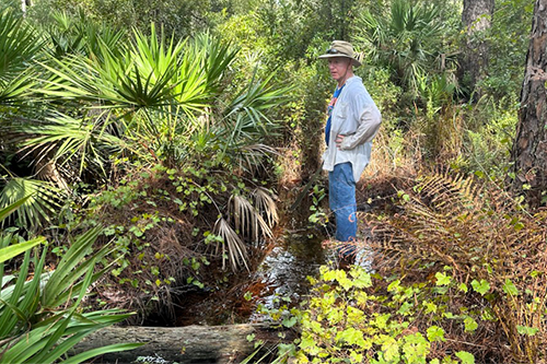
Central to the LMCA is Lake Moore, a 17.19-acre freshwater lake. Additionally, DRMP’s environmental scientists evaluated the soil types, revealing that approximately 47 percent of the project area comprises pine flatwoods and longleaf pine.
A new trailhead and parking area will be established near Dr. Martin Luther King Jr. Boulevard with a parking study to ensure optimal design. Five unpaved trails totaling 2.64 miles will offer routes for walking, jogging, and hiking, with an elevated boardwalk planned for the Orange Trail to improve accessibility in wet areas. Educational kiosks and signs will provide visitors with information on the park's history and local wildlife.
Under the plan, Lake Moore will see the addition of a new stationary dock and a kayak launch to support picnicking, fishing, and paddling. These developments are set to begin in 2025, depending on funding.
Wildlife Assessment
We also conducted a protected species assessment for LMCA, using data and aerial imagery to identify wildlife and plan for species listed as threatened and endangered. This evaluation follows guidelines from the U.S. Fish & Wildlife Service (USFWS), Florida Fish & Wildlife Conservation Commission (FFWCC), and the Florida Natural Areas Inventory (FNAI). LMCA is within the consultation areas for the Florida scrub jay and red-cockaded woodpecker and also falls within the Core Foraging Area for the wood stork. The assessment identified 21 federally or state-protected species potentially present in or near LMCA, including alligators, Eastern Indigo snakes, gopher tortoises, Florida pine snakes, Florida Black Bears, and several birds of prey. Additionally, DRMP’s Environmental Scientists assessed non-native and invasive plant species, as well as cultural and historical resources.
The City aims to:
- Protect, monitor, and restore native vegetation and natural communities
- Update species occurrence inventories
- Maintain habitat conditions for designated species
- Monitor and control non-native and invasive species
- Provide quality recreational facilities and ensure safety
- Enhance public access to environmental education
- Implement Best Management Practices (BMPs) and adhere to the Perpetual Conservation Easement's capacity requirements
The City's goal is to maintain and restore LMCA’s natural communities, native vegetation, and protected species. DRMP is honored to provide our expertise to develop this plan to help preserve the area's unique ecological character while providing a valuable recreational resource for the community.
George McLatchey, PWS, CEP, is a DRMP Vice President and Environmental Services Division Manager.
Related Articles
- Nov21Giving Buses a Head Start in Raleigh, N.C. Raleigh's bustling corridors can make it...See Details
- Nov20Celebrating National GIS Day 2024As we celebrate National GIS Day, DRMP�...See Details
- Nov6Ewire Featured Story: PDES Team Guides Projects for Federal Compliance and SuccessLed by an experienced and versatile grou...See Details
- Nov6Expertise Highlight: Combating Flooding in Underserved Arkansas Communities In many predominantly Black rural towns ...See Details
Categories
- All
- Alternative Delivery
- Construction Services
- Disaster Resilience and Sustainability
- DRMPCares
- Ecological Services
- Federal Services
- Geographic Information Systems
- Land Development
- NEPA
- Project Development & Environment
- Structural Engineering
- Subsurface Utility Engineering
- Surveying & Mapping
- Traffic Impact Analysis
- Transportation
- Transportation Planning/Project Development
- Utilities Engineering
- Water Resources/Stormwater Management
Contributors
- Michael K. Albano, PE
- Bruno J. Arriola, PE, ENV SP
- Brent Bass, PE, PSM
- Cody Bayer, PE
- Donald W. Brown, PE
- Kyle Brown, PE
- Zach J. Carnahan, PE
- Brian Crowl, PE
- Patrick Day, PE
- Nick DeVito, PE
- Matt Floyd, PSM
- Deshon M. Fox, PE
- Scott Garth, PE, LEED AP ND
- Ryan M. Grab, CST II
- Robyn Hartz
- Jim Highland, PE
- TJ Lallathin, Jr., PE, DBIA
- Kelly Marton, GISP
- Meaghan McCarthy
- Jay McInnis, PE, CPM
- George McLatchey, PWS, CEP
- Michael McNeese
- Jeff Miller
- Ryan Mitchell, PE
- Lisa Moon, PE
- Megan E. Mott, PE
- Josh Norman
- Melissa Padilla Cintron, SIT
- Pavan Paiavula, PE
- Julian Poole, PE
- Joce Pritchett, PE
- Abby Rains
- Leo Rodriguez, PE
- Rachel L. Schmidt, PWS
- Logan Shappell
- Brian V. Smith
- Rynal Stephenson, PE
- Deston Taylor, EI
- August Thick II, PLS, CST III
- Steven L. Wallace, PE
- Orville Williams
- Amanda E. Woods, PE
Recent Articles
- 11/21/24Giving Buses a Head Start in Raleigh, N.C.
- 11/20/24Celebrating National GIS Day 2024
- 11/6/24Ewire Featured Story: PDES Team Guides Projects for Federal Compliance and Success
- 11/6/24Expertise Highlight: Combating Flooding in Underserved Arkansas Communities
- 11/6/24 DRMP Employees Join Forces to Create Lasting Impact in Local Communities