- Discover
-
Expertise
-
Alternative Delivery
- I-275 at I-4 Downtown Tampa Interchange Design-Build
- Wekiva Parkway Section 8 Interchange
- US 17/92 Interchange at SR 436
- SR 9B Extension from I-95 to US 1
- A. Max Brewer Bridge Replacement
- I-95 Widening from the Indian River/Brevard County Line to Malabar Road
- SR 528 (Beachline Expressway) at Innovation Way Interchange
- SR 570 Polk Parkway Widening from I-4 to Pace Road
- I-95 Express Lanes and Ramp Signals – Phase 3A-1
- Pollard Road Extension over Peace Creek
- I-485 Widening from I-77 to Rea Road
- Monroe Bypass/Connector Design-Build
- Construction Services
- Ecological Services
-
Federal Services
- Range of the Future Study
- US Coast Guard Air Station (Clearwater)
- Ascension Island Fire Station Renovation
- Patrick Space Force Base Water Lines Repair
- Patrick Space Force Base Living Shoreline Restoration
- P-505 Electrical Hardening and Black Start CHP at Marine Corps Air Station Beaufort
- Naval Station at Guantanamo Bay Survey Services
- Repair Phillips Parkway and Speed Limit Study
- Ascension Island Auxiliary Airfield Surveying and Mapping Services
-
Geographic Information Systems (GIS)
- Thermal Design/Comprehensive Campus LiDAR Collection
- Greater Orlando Aviation Authority (GOAA) Strategic Commerical Land Development Program
- University of Florida Sanitary Sewer GIS Mapping
- Ascension Island Auxiliary Airfield GIS Integration
- Santa Rosa County School District's School Transportation & Capacity GIS Analysis
- Gainesville Community Redevelopment Agency Socioeconomic Analysis and Site Suitability Report
- Real Estate Site Suitability and Development Analysis
- SR 836 (Dolphin Expressway) GIS Asset Inventory of Pre-Post Construction
- Alachua County Public Schools GIS and School Planning Professional Services
- Patrick Space Force Base Living Shoreline Restoration GIS Analysis
- Florida Army National Guard Readiness Center GIS Inventory & Integration
- Comprehensive Transit Study Puerto Rico GIS Analysis
- Land Development
- Structural Engineering
-
Subsurface Utility Engineering (SUE)
- Thermal Design/Comprehensive Campus LiDAR Collection
- P-505 Electrical Hardening and Black Start CHP at Marine Corps Air Station Beaufort
- Resurface & Safety Improvements Turnpike Mainline
- University of Florida Rabon Utility Mapping
- FP&L Subsurface Utility Engineering Continuing On-Call Contract
- Lockheed Martin Subsurface Utility Engineering Services
- Palm Coast Parkway Subsurface Utility Engineering Services
- Surveying & Mapping/Geospatial
-
Traffic Impact Analysis
- 505 West Chapel Hill Street
- 5th Street Station
- Beale Farm Industrial Park
- Blue Mountain Mist Resort
- The Villages at McCullers Walk
- Fredericksburg National Baseball Stadium
- Hendrick Southpoint Auto Mall
- Apex Friendship Elementary School
- Whole Foods Center
- Barclay West
- Grove 98
- Pullen Drive Extension/Catholic Diocese
- Trails/Parks & Recreation Facilities
- Transportation
-
Utilities Engineering
- Ascension Island Fire Station Renovation
- M-1 Canal Water Main Extension
- 5th Street Bridge Utility Replacement
- Captain’s Cove Wastewater Plant Revisions & Permit Renewal
- City of Fort Myers Downtown Utility & Streetscape Improvement
- Florida Caverns State Park Lift Station Rehab
- Tween Waters Inn Wastewater Plant Permit Renewal
- City of Fort Myers Wastewater Capacity Studies
- Patrick Space Force Base Water Lines Repair
- Big Lagoon Boat Ramp Wastewater System
- St. Joseph State Park Septic Tank Replacement
- WildBlue Development Wastewater Modeling
- A-1 Gator Wastewater Capacity Increase
- Water Resources/Stormwater Management
-
Alternative Delivery
- Careers
- Insights
- Connect
- Powered By Trilon

DRMP's PD&E Study Supports Mexico Beach, Fla., Revitalization with Multi-Use Path
August 27th, 2024


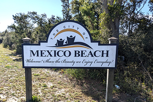
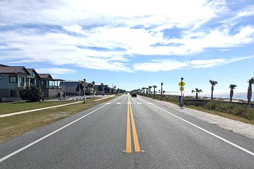
Located along Florida’s Gulf Coast in Bay County, Mexico Beach is a small coastal community connected by US 98 (SR 30), a crucial roadway for residents and visitors. It provides access to the beach, homes, businesses, and neighboring communities along the shoreline. After Hurricane Michael devastated the area in 2018, rebuilding efforts have brought new attention to how this corridor can better serve the city.
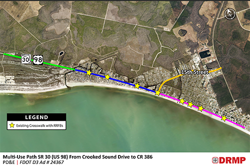
The Florida Department of Transportation (FDOT) selected DRMP to conduct a Project Development and Environment (PD&E) study for a proposed multi-use path along US 98. The project is part of FDOT’s Great Northwest Coastal Trail system and is intended to strengthen regional connectivity while supporting long-term transportation needs.
The proposed 4.2-mile multi-use path would extend along US 98 from west of the Mexico Beach city limits at Crooked Sound Drive, with an additional segment connecting the US 98 and 15th Street intersection to CR 386 along 15th Street. It is designed to improve bicycle and pedestrian safety, expand recreational opportunities, and support economic growth.
DRMP’s Project Development and Environmental Services (PDES) team helped assist Mexico Beach’s recovery from Hurricane Michael's devastating impact, which struck the area as a Category 4 storm and damaged or destroyed 85 percent of the city’s homes. The multi-use path is an important step toward revitalizing the community.
Since the hurricane, the city has focused on rebuilding by studying resilience, collaborating with state and federal agencies, and implementing new ordinances to enhance growth while preserving its small-town charm.
Project Goals
The primary goals of this PD&E Study – which started earlier this year and is expected to be completed in mid-2026 – are to develop and evaluate viable alternatives that align with the project’s objectives; assess environmental impacts; and analyze the project's effects on the social, economic, cultural, natural, and physical environment. The idea is to improve regional and community connectivity through a dedicated multi-use path that supports pedestrian and bicycle traffic.
A key element of the PD&E Study is public involvement. By fostering an inclusive dialogue, our goals are to keep the public informed about project developments and potential impacts, and gather feedback from a wide range of stakeholders to refine the project scope and objectives.
Residents are already expressing excitement for the project.
“I own two properties on US 98 in Mexico Beach, and I wanted to write and let you know I support this project,” wrote one resident in an email to FDOT officials. “It is very much needed.”
Another resident also expressed support for the project to FDOT officials. “We have a property in Mexico Beach on 40th street. We are super excited about the project and can't wait for it to be completed. So needed! All your project goals will definitely be accomplished. Thank you for doing it.”
Why This Project Matters
The proposed multi-use path is a strategic response to the growing demand for alternative transportation options. With increased population growth and tourism, there is a pressing need for facilities that support non-motorized movement.
The path will improve safety and provide dedicated facilities for pedestrians and cyclists, which will help reduce conflicts with motor vehicles. It also will contribute to improved quality of life, offering a safe and enjoyable way for residents and visitors to recreate and explore.
Key to the city’s resiliency plan are stormwater management projects and a citywide Greenway-Blueway trail system to improve water quality, reduce flooding, and bolster storm resilience. The multi-use path along US 98 is a significant component of this effort, supported by the Environmental Protection Agency and FEMA studies and included in Bay County’s Long-Range Transportation plan.
DRMP's approach involves using Mobile LiDAR for efficient and accurate data collection, integrating hydrographic data for a comprehensive project file, and considering Access Management and ADA guidelines in the roadway design with the proposed shared-use path on the north side of US 98 to ensure safety and functionality.
As we advance this project toward final design, DRMP remains committed to ensuring thorough agency coordination, public involvement, technical support, and environmental compliance. By collaborating with all stakeholders, our goal is to achieve FDOT approval for the preferred alternative and successfully complete this project, which will benefit the community and the environment.
Posted in the categories All, Disaster Resilience and Sustainability , NEPA , Project Development & Environment , Surveying & Mapping, Transportation, Transportation Planning/Project Development .
Related Articles
 Jul21Wekiva Parkway Section 8 Interchange Closes Gap, Improves Regional Travel The Wekiva Parkway Section 8 Interchange...See Details
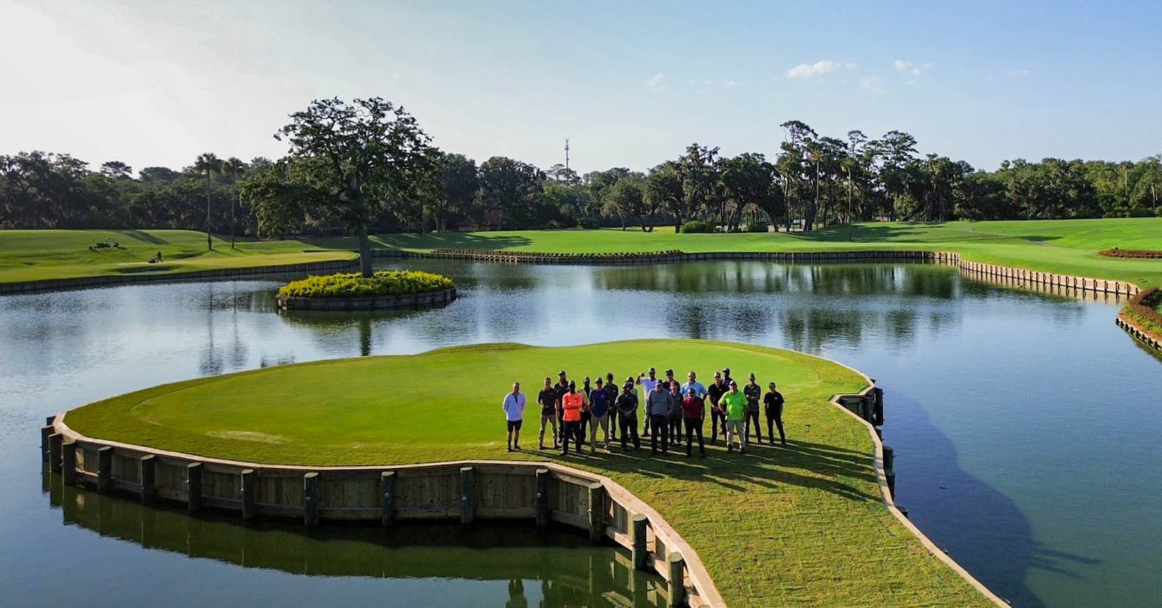 Jul14Surveying One of Golf’s Most Legendary Holes DRMP provided survey services for the re...See Details
 Jul7Port St. Lucie Intersection Upgrade Improves Safety at Village and Tradition ParkwaysDRMP delivered a comprehensive redesign ...See Details
 Jun25What Does Safety Look Like at DRMP Through a Safety Leader’s Eyes?Creating a safe workplace requires atten...See Details

Categories
- All
- Alternative Delivery
- Civil Services
- Construction Services
- Disaster Resilience and Sustainability
- DRMPCares
- Ecological Services
- Electrical Engineering
- eWIRE
- Federal Services
- Geographic Information Systems
- Hurricane
- Land Development
- Learning & Development
- NEPA
- Project Development & Environment
- Structural Engineering
- Subsurface Utility Engineering
- Surveying & Mapping
- Traffic Impact Analysis
- Transportation
- Transportation Planning/Project Development
- Utilities Engineering
- Water Resources/Stormwater Management
Contributors
- Michael K. Albano, PE
- Bruno J. Arriola, PE, ENV SP
- Alia Awwad, PE
- Brent Bass, PE, PSM
- Cody Bayer, PE
- Maria Bazemore, PWS, AICP
- Paul Benvie, PE
- Donald W. Brown, PE
- Kyle Brown, PE
- Jake Burton
- Zach J. Carnahan, PE
- David Couch
- Brian Crowl, PE
- Patrick Day, PE
- Nick DeVito, PE
- Joe Di Benedetto, PLS, LS
- Scott Garth, PE, LEED AP ND
- Ryan M. Grab, CST II
- Robyn Hartz, INCE
- Justin Hayes, EI
- Lucas S. Helms, PE
- Jim Highland, PE
- Ryan Ianacone, CST II
- Erica Jernigan, PE
- Ravneet Kathuria
- TJ Lallathin, Jr., PE, DBIA
- Jay McInnis, PE, CPM
- George McLatchey, PWS, CEP
- Ryan Mitchell, PE
- Megan E. Mott, PE
- Josh Norman
- Melissa Padilla Cintron, SIT
- Pavan Paiavula, PE
- Ryan Pellarin, PE, CCM
- AJ Perkinson, PLS
- Julian Poole, PE
- Kayla Poulos, PE
- Kim Sadowski, PE, RSP1
- John Schick, PTP
- Rachel L. Schmidt, PWS
- Logan Shappell
- Rynal Stephenson, PE
- Albert Taylor
- Deston Taylor, PE, PTOE
- Keelyn Taylor, PhD
- August Thick II, PLS
- Thomas Tracz, PSM
- Hung Tu, PE, SE
- Grady Vaughan, PE, PTOE, PTP
- Orville Williams
- Amanda E. Woods, PE


