- Discover
-
Expertise
-
Alternative Delivery
- I-275 at I-4 Downtown Tampa Interchange Design-Build
- Wekiva Parkway Section 8 Interchange
- US 17/92 Interchange at SR 436
- SR 9B Extension from I-95 to US 1
- A. Max Brewer Bridge Replacement
- I-95 Widening from the Indian River/Brevard County Line to Malabar Road
- SR 528 (Beachline Expressway) at Innovation Way Interchange
- SR 570 Polk Parkway Widening from I-4 to Pace Road
- I-95 Express Lanes and Ramp Signals – Phase 3A-1
- Pollard Road Extension over Peace Creek
- I-485 Widening from I-77 to Rea Road
- Monroe Bypass/Connector Design-Build
- Construction Services
- Ecological Services
-
Federal Services
- Range of the Future Study
- US Coast Guard Air Station (Clearwater)
- Ascension Island Fire Station Renovation
- Patrick Space Force Base Water Lines Repair
- Patrick Space Force Base Living Shoreline Restoration
- P-505 Electrical Hardening and Black Start CHP at Marine Corps Air Station Beaufort
- Naval Station at Guantanamo Bay Survey Services
- Repair Phillips Parkway and Speed Limit Study
- Ascension Island Auxiliary Airfield Surveying and Mapping Services
-
Geographic Information Systems (GIS)
- Thermal Design/Comprehensive Campus LiDAR Collection
- Greater Orlando Aviation Authority (GOAA) Strategic Commerical Land Development Program
- University of Florida Sanitary Sewer GIS Mapping
- Ascension Island Auxiliary Airfield GIS Integration
- Santa Rosa County School District's School Transportation & Capacity GIS Analysis
- Gainesville Community Redevelopment Agency Socioeconomic Analysis and Site Suitability Report
- Real Estate Site Suitability and Development Analysis
- SR 836 (Dolphin Expressway) GIS Asset Inventory of Pre-Post Construction
- Alachua County Public Schools GIS and School Planning Professional Services
- Patrick Space Force Base Living Shoreline Restoration GIS Analysis
- Florida Army National Guard Readiness Center GIS Inventory & Integration
- Comprehensive Transit Study Puerto Rico GIS Analysis
- Land Development
- Structural Engineering
-
Subsurface Utility Engineering (SUE)
- Thermal Design/Comprehensive Campus LiDAR Collection
- P-505 Electrical Hardening and Black Start CHP at Marine Corps Air Station Beaufort
- Resurface & Safety Improvements Turnpike Mainline
- University of Florida Rabon Utility Mapping
- FP&L Subsurface Utility Engineering Continuing On-Call Contract
- Lockheed Martin Subsurface Utility Engineering Services
- Palm Coast Parkway Subsurface Utility Engineering Services
- Surveying & Mapping/Geospatial
-
Traffic Impact Analysis
- 505 West Chapel Hill Street
- 5th Street Station
- Beale Farm Industrial Park
- Blue Mountain Mist Resort
- The Villages at McCullers Walk
- Fredericksburg National Baseball Stadium
- Hendrick Southpoint Auto Mall
- Apex Friendship Elementary School
- Whole Foods Center
- Barclay West
- Grove 98
- Pullen Drive Extension/Catholic Diocese
- Trails/Parks & Recreation Facilities
- Transportation
-
Utilities Engineering
- Ascension Island Fire Station Renovation
- M-1 Canal Water Main Extension
- 5th Street Bridge Utility Replacement
- Captain’s Cove Wastewater Plant Revisions & Permit Renewal
- City of Fort Myers Downtown Utility & Streetscape Improvement
- Florida Caverns State Park Lift Station Rehab
- Tween Waters Inn Wastewater Plant Permit Renewal
- City of Fort Myers Wastewater Capacity Studies
- Patrick Space Force Base Water Lines Repair
- Big Lagoon Boat Ramp Wastewater System
- St. Joseph State Park Septic Tank Replacement
- WildBlue Development Wastewater Modeling
- A-1 Gator Wastewater Capacity Increase
- Water Resources/Stormwater Management
-
Alternative Delivery
- Careers
- Insights
- Connect
- Powered By Trilon
Deadly Gainesville Corridor Transformed with Cutting Edge Surveying and Pedestrian Safety Upgrades
March 26th, 2026


The tragic deaths of two University of Florida (UF) students struck by vehicles on University Avenue (State Road 26) in Gainesville in 2020 and 2021 brought renewed attention to the safety of pedestrians along this busy corridor.
In response, the Florida Department of Transportation (FDOT) launched the SR 26 Safety Improvements project to enhance safety along the corridor from Gale Lemerand Drive to Northwest 14th Street.
DRMP’s Survey Services played a critical role in the project, providing the survey and subsurface utility engineering (SUE) data needed to support the design and construction of raised crosswalks, enhanced lighting, and shorter crossing distances. In August 2025, the project received the Safety – Small Project award from the Southeastern Association of State Highway and Transportation Officials (SASHTO) as part of the 2025 America’s Transportation Awards.
Local Expertise in Gainesville
In addition to SR 26, DRMP’s survey and SUE teams have extensive experience supporting major corridors, campus infrastructure, and utility projects throughout the Gainesville region.
With a strong local presence, DRMP coordinates with field crews and stakeholders to deliver high-quality survey and SUE data on schedule. The team’s regional knowledge, advanced technology, and field expertise ensure reliable results and help agencies and institutions make informed decisions for long-term planning.
Equipped with mobile LiDAR, Unmanned Aerial Vehicle (UAV) scanning, 3D topographic mapping, and comprehensive utility verification capabilities, DRMP captures roadway alignments, drainage structures, underground utilities, and hard-to-access areas. Our experts work closely with engineers, planners, and utility providers to verify existing conditions, minimize construction risks, and help projects move forward efficiently and safely.
Above and Below the Surface
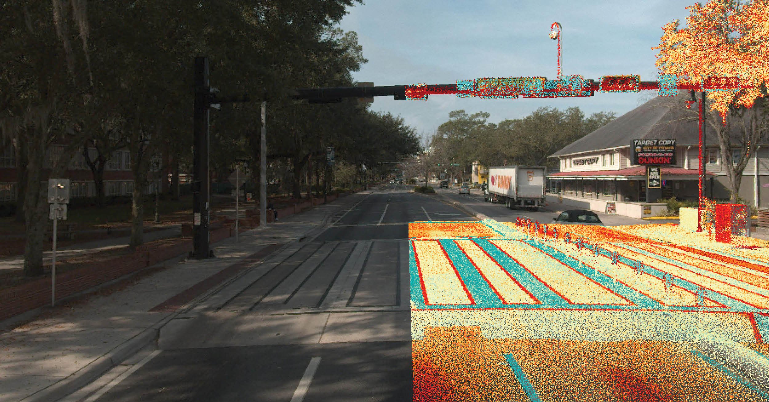
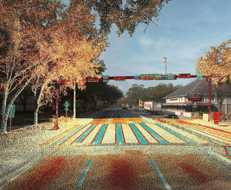
Making a busy corridor such as SR 26 safer for everyone starts with understanding exactly what’s already there. For the SR 26 Safety Improvements project, DRMP laid the groundwork by setting precise reference points to ensure every feature along the corridor was accurately mapped. We documented existing alignments, mapped utilities for eight companies, and measured drainage structures, pipe sizes, and other key infrastructure. Clearance surveys were completed for light poles and mast arms, and mobile LiDAR captured hard-to-see areas, giving designers a complete view of current conditions. By providing this detailed, verified information, DRMP helped the design team plan and deliver improvements efficiently and safely.
DRMP applied the same approach to other major corridors, including SR 24, SR 121, US 301, and West Newberry Road. Using 3D topographic surveys, right-of-way mapping, mobile and UAV LiDAR scanning, and utility verification, we created reliable datasets for designers and engineers. These datasets guide roadway improvements, intersection upgrades, and pedestrian safety enhancements.
Mapping the University of Florida
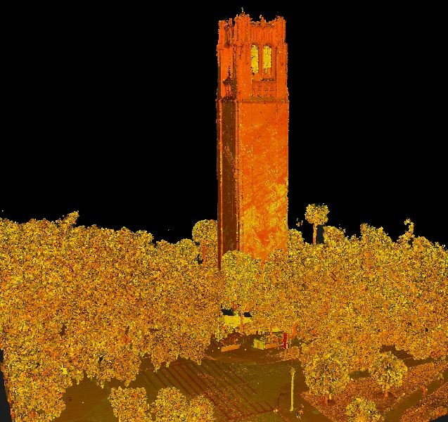
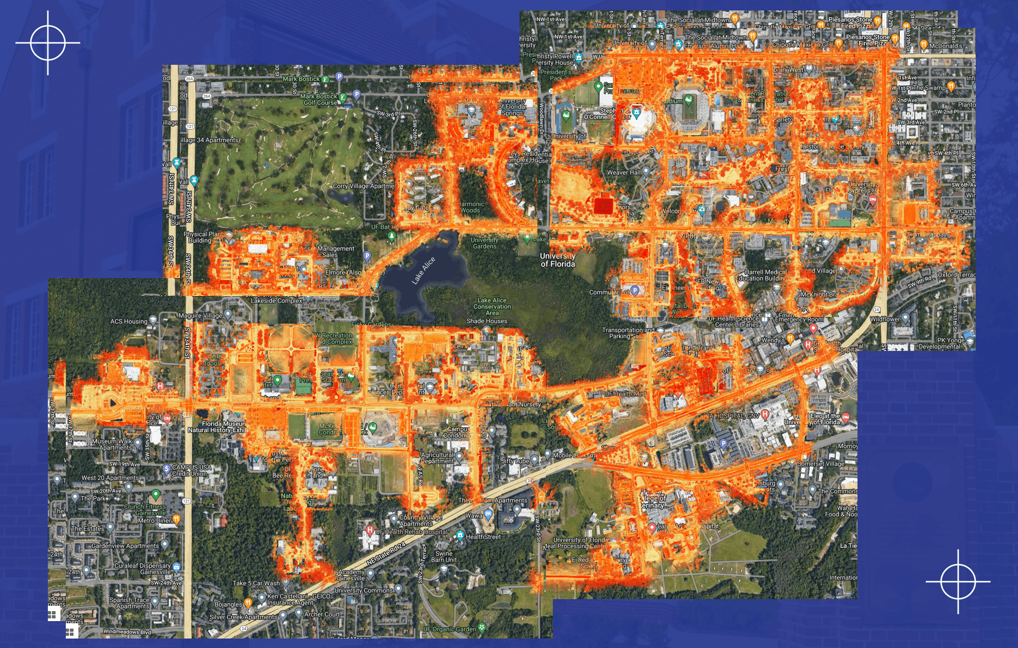
Through an ongoing continuing services contract with UF, DRMP completed a 68-mile LiDAR and GIS survey capturing roadways, parking areas, green spaces, and forested areas around the campus. Mobile LiDAR scans of over 20 miles of roadways assisted with studies on pedestrian safety, ADA compliance, and street lighting. Additional scans of lakes, sports fields, and other areas that are difficult to access produced a fully integrated 3D model of the campus. This dataset allows UF to plan campus growth, coordinate infrastructure projects, and verify design plans without disrupting academic or athletic activities.
Utility-specific projects, such as the UF-623 Central Energy Plant and Museum Road Thermal Replacement, highlight DRMP’s SUE expertise. For Museum Road, DRMP mapped buried utilities using Quality Level B designation, identifying the location, type, size, and material of underground lines. To confirm exact positions, we performed Quality Level A verification with limited test holes and trenching. Hundreds of verifications ensured 141 utility lines and duct banks were accurately documented.
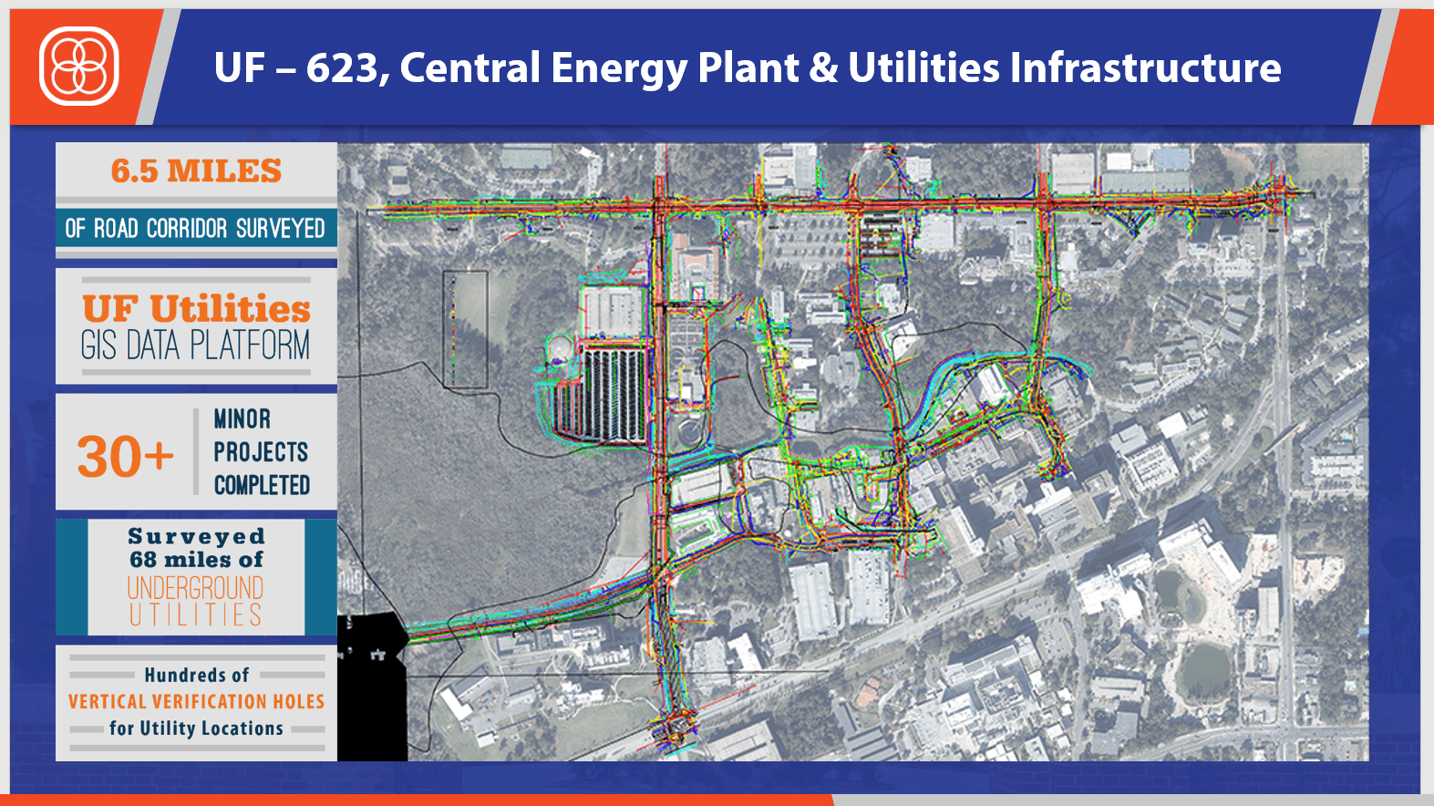
All field data was integrated into digital maps and GIS databases, producing 3D models, web maps, and easy-to-use visual tools for planners and engineers. Combined with surveys of roads, drainage, and terrain, this information turns complex underground and above-ground data into actionable insights.
DRMP’s work in Gainesville demonstrates how precise surveying, advanced scanning technologies, and utility verification come together to make infrastructure safer, construction smarter, and planning more reliable. By seeing above and below the surface, DRMP helps communities and agencies build with confidence and efficiency. For more information on our surveying and mapping services contact us here.
Thomas Tracz, PSM, serves as a Senior Project Manager for DRMP’s Survey and Mapping/Geospatial Market Sector.

Related Articles
 Jul23DRMP Gives Families a Lift Through Its Charity Bike BuildDRMP employees took time out of their da...See Details
 Jul21Wekiva Parkway Section 8 Interchange Closes Gap, Improves Regional Travel The Wekiva Parkway Section 8 Interchange...See Details
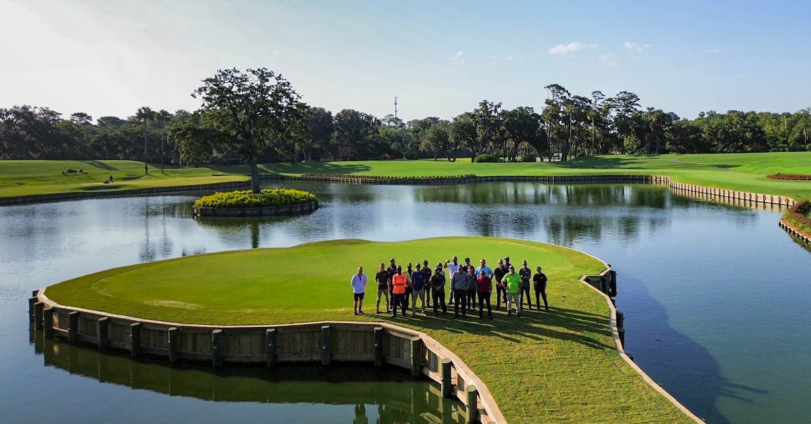 Jul14Surveying One of Golf’s Most Legendary Holes DRMP provided survey services for the re...See Details
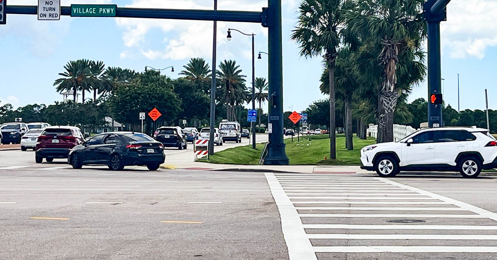 Jul7Port St. Lucie Intersection Upgrade Improves Safety at Village and Tradition ParkwaysDRMP delivered a comprehensive redesign ...See Details

Categories
- All
- Alternative Delivery
- Civil Services
- Construction Services
- Disaster Resilience and Sustainability
- DRMPCares
- Ecological Services
- Electrical Engineering
- eWIRE
- Federal Services
- Geographic Information Systems
- Hurricane
- Land Development
- Learning & Development
- NEPA
- Project Development & Environment
- Structural Engineering
- Subsurface Utility Engineering
- Surveying & Mapping
- Traffic Impact Analysis
- Transportation
- Transportation Planning/Project Development
- Utilities Engineering
- Water Resources/Stormwater Management
Contributors
- Michael K. Albano, PE
- Bruno J. Arriola, PE, ENV SP
- Alia Awwad, PE
- Brent Bass, PE, PSM
- Cody Bayer, PE
- Maria Bazemore, PWS, AICP
- Paul Benvie, PE
- Donald W. Brown, PE
- Kyle Brown, PE
- Jake Burton
- Zach J. Carnahan, PE
- David Couch
- Brian Crowl, PE
- Patrick Day, PE
- Nick DeVito, PE
- Joe Di Benedetto, PLS, LS
- Scott Garth, PE, LEED AP ND
- Ryan M. Grab, CST II
- Robyn Hartz, INCE
- Justin Hayes, EI
- Lucas S. Helms, PE
- Jim Highland, PE
- Ryan Ianacone, CST II
- Erica Jernigan, PE
- Ravneet Kathuria
- TJ Lallathin, Jr., PE, DBIA
- Jay McInnis, PE, CPM
- George McLatchey, PWS, CEP
- Ryan Mitchell, PE
- Megan E. Mott, PE
- Josh Norman
- Melissa Padilla Cintron, SIT
- Pavan Paiavula, PE
- Ryan Pellarin, PE, CCM
- AJ Perkinson, PLS
- Julian Poole, PE
- Kayla Poulos, PE
- Kim Sadowski, PE, RSP1
- John Schick, PTP
- Rachel L. Schmidt, PWS
- Logan Shappell
- Rynal Stephenson, PE
- Albert Taylor
- Deston Taylor, PE, PTOE
- Keelyn Taylor, PhD
- August Thick II, PLS
- Thomas Tracz, PSM
- Hung Tu, PE, SE
- Grady Vaughan, PE, PTOE, PTP
- Orville Williams
- Amanda E. Woods, PE


