- Discover
-
Expertise
-
Alternative Delivery
- I-275 at I-4 Downtown Tampa Interchange Design-Build
- Wekiva Parkway Section 8 Interchange
- US 17/92 Interchange at SR 436
- SR 9B Extension from I-95 to US 1
- A. Max Brewer Bridge Replacement
- I-95 Widening from the Indian River/Brevard County Line to Malabar Road
- SR 528 (Beachline Expressway) at Innovation Way Interchange
- SR 570 Polk Parkway Widening from I-4 to Pace Road
- I-95 Express Lanes and Ramp Signals – Phase 3A-1
- Pollard Road Extension over Peace Creek
- I-485 Widening from I-77 to Rea Road
- Monroe Bypass/Connector Design-Build
- Construction Services
- Ecological Services
-
Federal Services
- Range of the Future Study
- US Coast Guard Air Station (Clearwater)
- Ascension Island Fire Station Renovation
- Patrick Space Force Base Water Lines Repair
- Patrick Space Force Base Living Shoreline Restoration
- P-505 Electrical Hardening and Black Start CHP at Marine Corps Air Station Beaufort
- Naval Station at Guantanamo Bay Survey Services
- Repair Phillips Parkway and Speed Limit Study
- Ascension Island Auxiliary Airfield Surveying and Mapping Services
-
Geographic Information Systems (GIS)
- Thermal Design/Comprehensive Campus LiDAR Collection
- Greater Orlando Aviation Authority (GOAA) Strategic Commerical Land Development Program
- University of Florida Sanitary Sewer GIS Mapping
- Ascension Island Auxiliary Airfield GIS Integration
- Santa Rosa County School District's School Transportation & Capacity GIS Analysis
- Gainesville Community Redevelopment Agency Socioeconomic Analysis and Site Suitability Report
- Real Estate Site Suitability and Development Analysis
- SR 836 (Dolphin Expressway) GIS Asset Inventory of Pre-Post Construction
- Alachua County Public Schools GIS and School Planning Professional Services
- Patrick Space Force Base Living Shoreline Restoration GIS Analysis
- Florida Army National Guard Readiness Center GIS Inventory & Integration
- Comprehensive Transit Study Puerto Rico GIS Analysis
- Land Development
- Structural Engineering
-
Subsurface Utility Engineering (SUE)
- Thermal Design/Comprehensive Campus LiDAR Collection
- P-505 Electrical Hardening and Black Start CHP at Marine Corps Air Station Beaufort
- Resurface & Safety Improvements Turnpike Mainline
- University of Florida Rabon Utility Mapping
- FP&L Subsurface Utility Engineering Continuing On-Call Contract
- Lockheed Martin Subsurface Utility Engineering Services
- Palm Coast Parkway Subsurface Utility Engineering Services
- Surveying & Mapping/Geospatial
-
Traffic Impact Analysis
- 505 West Chapel Hill Street
- 5th Street Station
- Beale Farm Industrial Park
- Blue Mountain Mist Resort
- The Villages at McCullers Walk
- Fredericksburg National Baseball Stadium
- Hendrick Southpoint Auto Mall
- Apex Friendship Elementary School
- Whole Foods Center
- Barclay West
- Grove 98
- Pullen Drive Extension/Catholic Diocese
- Trails/Parks & Recreation Facilities
- Transportation
-
Utilities Engineering
- Ascension Island Fire Station Renovation
- M-1 Canal Water Main Extension
- 5th Street Bridge Utility Replacement
- Captain’s Cove Wastewater Plant Revisions & Permit Renewal
- City of Fort Myers Downtown Utility & Streetscape Improvement
- Florida Caverns State Park Lift Station Rehab
- Tween Waters Inn Wastewater Plant Permit Renewal
- City of Fort Myers Wastewater Capacity Studies
- Patrick Space Force Base Water Lines Repair
- Big Lagoon Boat Ramp Wastewater System
- St. Joseph State Park Septic Tank Replacement
- WildBlue Development Wastewater Modeling
- A-1 Gator Wastewater Capacity Increase
- Water Resources/Stormwater Management
-
Alternative Delivery
- Careers
- Insights
- Connect
- Powered By Trilon
DRMP’s Innovative GIS Tool Streamlines Parcel Data for Faster, Smarter Project Delivery
April 15th, 2026


When a bridge or roadway project is planned, the surrounding development raises important questions: Which parcels will be affected? Who owns them? How will construction impact property lines? Traditionally, answering these questions meant accessing multiple state websites to get this information, downloading mismatched files, and spending hours – or sometimes days – to assemble accurate parcel data.
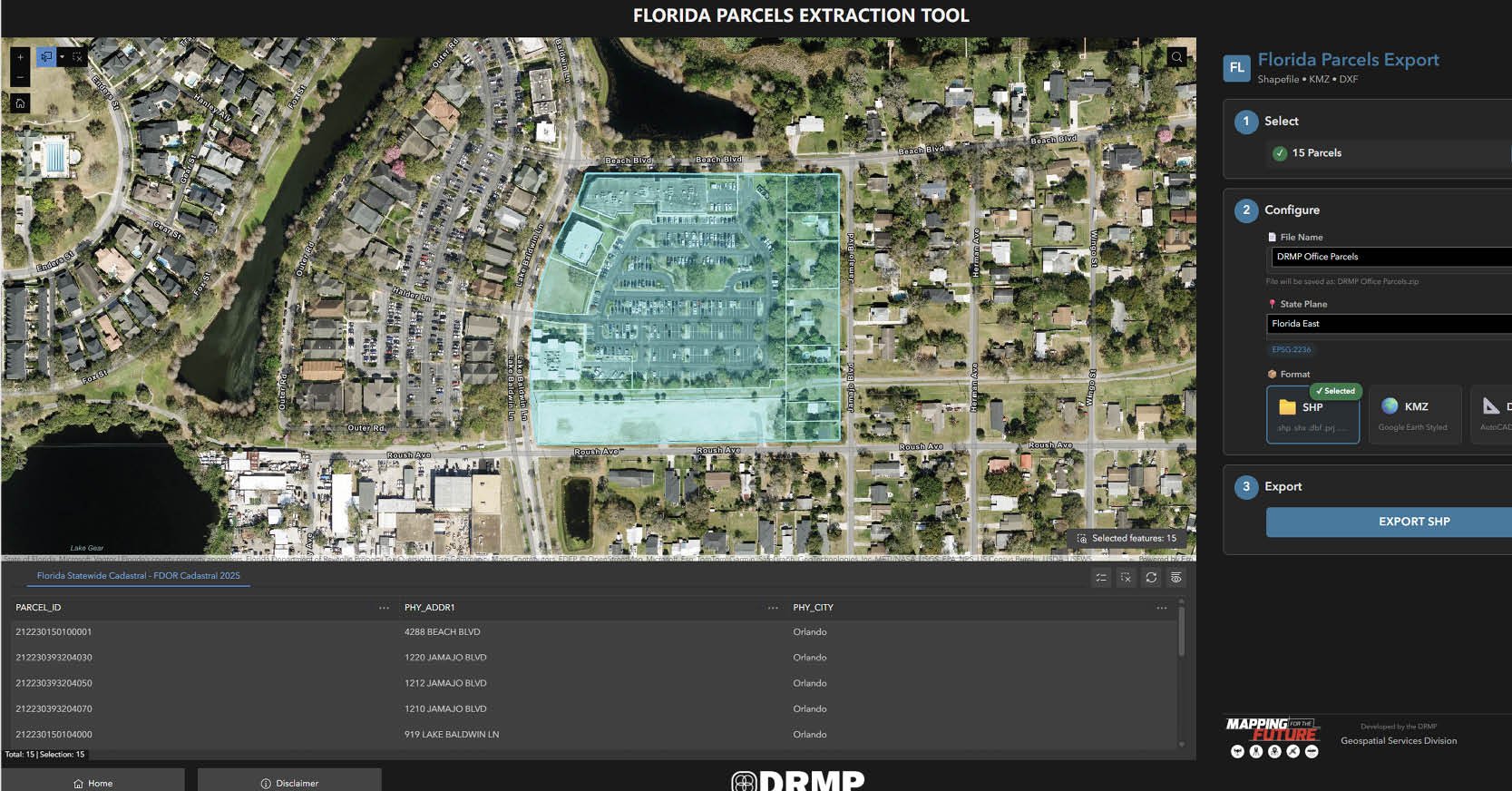
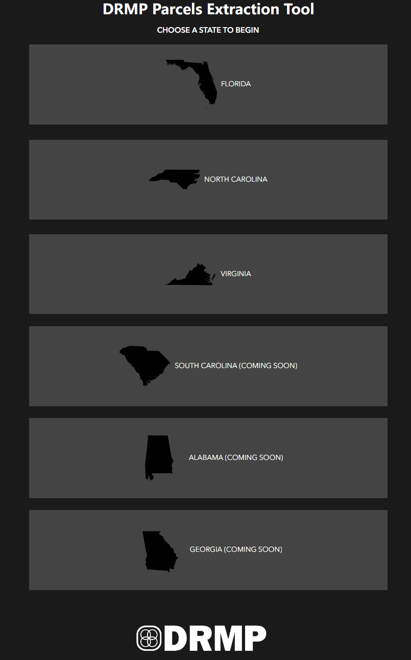
To streamline this process, DRMP’s Geospatial Services Division developed the Parcels Extraction Tool, an internal application designed to simplify access to parcel data in multiple states where DRMP operates, including Florida, North Carolina, and Virginia, with plans to add additional states. With just a few clicks, users can select parcels and instantly view ownership details, parcel ID numbers, and addresses. The tool also enables visualization of affected areas in 3D after the data is downloaded and exported to KMZ, Shapefile, or DXF formats.
An Innovative Solution
The idea for this tool came from Brent Bass, PE, PSM, a DRMP vice president and geospatial services division manager, and our Geographic Information Systems (GIS) team was responsible for developing it. Brent envisioned a tool that would allow users to access parcel data for any county all in one place in just a few clicks.
Many planners, surveyors, engineers, and environmental specialists have difficulty accessing parcel data in multiple formats and on various state systems. Survey and environmental design workflows often produce different outputs, which adds complexity.
With the Parcels Extraction Tool, users can quickly select only the parcels they need, name the output file, export the data in multiple formats, and use maps that keep measurements and distances accurate. The tool also lets users zoom anywhere on the map without needing coordinates.
For example, when planning a roadway project, our team can easily identify which parcels will be affected and evaluate right-of-way impacts, allowing for more precise decisions that help reduce project delays and costs.
The tool is innovative not just in functionality but also in design. While DRMP usually relies on standard ESRI widgets, our GIS team customized out-of-the-box ESRI widgets to make the tool functional, user-friendly, and intuitive. After multiple iterations, the tool was refined so that complex parcel selection and visualization could be executed faster and easier.
The tool is primarily used by all disciplines for land information, planning, and surveying. Almost every department at DRMP needs some type of parcel information. Within days of the tool’s release, daily users increased from 25–50 to 50–100. Our survey teams are among the most active users.
Simplifying Parcel Data
Before this tool, gathering parcel data was a manual, time-consuming process. Users often had to visit county property appraiser or department of revenue (DOR) websites, search for parcels individually, and then reformat the data for use in their projects.
For projects in Florida, the tool connects directly to publicly available statewide data, providing access to more than 10 million parcels. Although the state publishes this information in standardized formats, those formats do not always align with engineering and design workflows.
Similar challenges exist in other states. In North Carolina, parcel data is available through NC OneMap, while in Virginia, it is provided by the Virginia Department of Emergency Management (VDEM). In each case, the data is accurate, but it often requires reformatting before it can be used effectively.
DRMP’s tool addresses this gap by connecting directly to public data services, including those delivered through a Representational State Transfer Application Programming Interface (REST API). A REST API allows software systems to request and exchange data automatically over the internet, eliminating the need for manual downloads or navigation using multiple platforms.
By consuming data from these sources and converting it into the required format, the tool delivers ready-to-use outputs. This reduces the need for multiple software steps and significantly improves efficiency from data collection to project execution.
As projects grow in scale and complexity, DRMP plans to expand the tool’s capabilities to support additional states and accommodate a wider range of data formats as needed. This continued development will help streamline workflows and ensure our teams can access and use parcel data more efficiently for projects. To learn more about our GIS services, click here.

Ravneet Kathuria serves as a GIS Analyst for DRMP's Surveying and Mapping/Geospatial Division.
Posted in the categories All, Geographic Information Systems.
Related Articles
 Jul23DRMP Gives Families a Lift Through Its Charity Bike BuildDRMP employees took time out of their da...See Details
 Jul21Wekiva Parkway Section 8 Interchange Closes Gap, Improves Regional Travel The Wekiva Parkway Section 8 Interchange...See Details
 Jul14Surveying One of Golf’s Most Legendary Holes DRMP provided survey services for the re...See Details
 Jul7Port St. Lucie Intersection Upgrade Improves Safety at Village and Tradition ParkwaysDRMP delivered a comprehensive redesign ...See Details

Categories
- All
- Alternative Delivery
- Civil Services
- Construction Services
- Disaster Resilience and Sustainability
- DRMPCares
- Ecological Services
- Electrical Engineering
- eWIRE
- Federal Services
- Geographic Information Systems
- Hurricane
- Land Development
- Learning & Development
- NEPA
- Project Development & Environment
- Structural Engineering
- Subsurface Utility Engineering
- Surveying & Mapping
- Traffic Impact Analysis
- Transportation
- Transportation Planning/Project Development
- Utilities Engineering
- Water Resources/Stormwater Management
Contributors
- Michael K. Albano, PE
- Bruno J. Arriola, PE, ENV SP
- Alia Awwad, PE
- Brent Bass, PE, PSM
- Cody Bayer, PE
- Maria Bazemore, PWS, AICP
- Paul Benvie, PE
- Donald W. Brown, PE
- Kyle Brown, PE
- Jake Burton
- Zach J. Carnahan, PE
- David Couch
- Brian Crowl, PE
- Patrick Day, PE
- Nick DeVito, PE
- Joe Di Benedetto, PLS, LS
- Scott Garth, PE, LEED AP ND
- Ryan M. Grab, CST II
- Robyn Hartz, INCE
- Justin Hayes, EI
- Lucas S. Helms, PE
- Jim Highland, PE
- Ryan Ianacone, CST II
- Erica Jernigan, PE
- Ravneet Kathuria
- TJ Lallathin, Jr., PE, DBIA
- Jay McInnis, PE, CPM
- George McLatchey, PWS, CEP
- Ryan Mitchell, PE
- Megan E. Mott, PE
- Josh Norman
- Melissa Padilla Cintron, SIT
- Pavan Paiavula, PE
- Ryan Pellarin, PE, CCM
- AJ Perkinson, PLS
- Julian Poole, PE
- Kayla Poulos, PE
- Kim Sadowski, PE, RSP1
- John Schick, PTP
- Rachel L. Schmidt, PWS
- Logan Shappell
- Rynal Stephenson, PE
- Albert Taylor
- Deston Taylor, PE, PTOE
- Keelyn Taylor, PhD
- August Thick II, PLS
- Thomas Tracz, PSM
- Hung Tu, PE, SE
- Grady Vaughan, PE, PTOE, PTP
- Orville Williams
- Amanda E. Woods, PE


