- Discover
-
Expertise
-
Alternative Delivery
- I-275 at I-4 Downtown Tampa Interchange Design-Build
- Wekiva Parkway Section 8 Interchange
- US 17/92 Interchange at SR 436
- SR 9B Extension from I-95 to US 1
- A. Max Brewer Bridge Replacement
- I-95 Widening from the Indian River/Brevard County Line to Malabar Road
- SR 528 (Beachline Expressway) at Innovation Way Interchange
- SR 570 Polk Parkway Widening from I-4 to Pace Road
- I-95 Express Lanes and Ramp Signals – Phase 3A-1
- Pollard Road Extension over Peace Creek
- I-485 Widening from I-77 to Rea Road
- Monroe Bypass/Connector Design-Build
- Construction Services
- Ecological Services
-
Federal Services
- Range of the Future Study
- US Coast Guard Air Station (Clearwater)
- Ascension Island Fire Station Renovation
- Patrick Space Force Base Water Lines Repair
- Patrick Space Force Base Living Shoreline Restoration
- P-505 Electrical Hardening and Black Start CHP at Marine Corps Air Station Beaufort
- Naval Station at Guantanamo Bay Survey Services
- Repair Phillips Parkway and Speed Limit Study
- Ascension Island Auxiliary Airfield Surveying and Mapping Services
-
Geographic Information Systems (GIS)
- Thermal Design/Comprehensive Campus LiDAR Collection
- Greater Orlando Aviation Authority (GOAA) Strategic Commerical Land Development Program
- University of Florida Sanitary Sewer GIS Mapping
- Ascension Island Auxiliary Airfield GIS Integration
- Santa Rosa County School District's School Transportation & Capacity GIS Analysis
- Gainesville Community Redevelopment Agency Socioeconomic Analysis and Site Suitability Report
- Real Estate Site Suitability and Development Analysis
- SR 836 (Dolphin Expressway) GIS Asset Inventory of Pre-Post Construction
- Alachua County Public Schools GIS and School Planning Professional Services
- Patrick Space Force Base Living Shoreline Restoration GIS Analysis
- Florida Army National Guard Readiness Center GIS Inventory & Integration
- Comprehensive Transit Study Puerto Rico GIS Analysis
- Land Development
- Structural Engineering
-
Subsurface Utility Engineering (SUE)
- Thermal Design/Comprehensive Campus LiDAR Collection
- P-505 Electrical Hardening and Black Start CHP at Marine Corps Air Station Beaufort
- Resurface & Safety Improvements Turnpike Mainline
- University of Florida Rabon Utility Mapping
- FP&L Subsurface Utility Engineering Continuing On-Call Contract
- Lockheed Martin Subsurface Utility Engineering Services
- Palm Coast Parkway Subsurface Utility Engineering Services
- Surveying & Mapping/Geospatial
-
Traffic Impact Analysis
- 505 West Chapel Hill Street
- 5th Street Station
- Beale Farm Industrial Park
- Blue Mountain Mist Resort
- The Villages at McCullers Walk
- Fredericksburg National Baseball Stadium
- Hendrick Southpoint Auto Mall
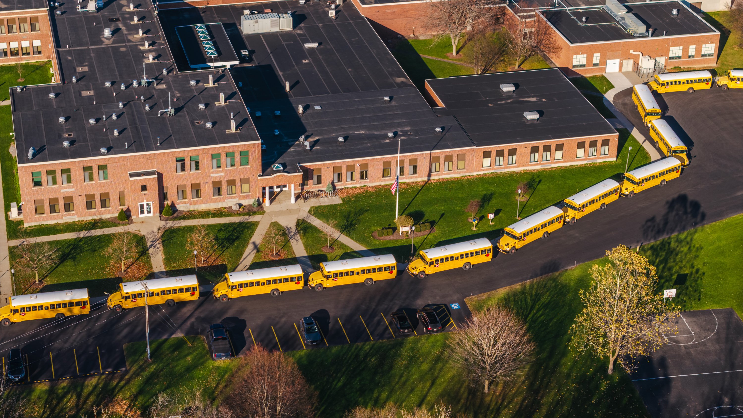
- Apex Friendship Elementary School
- Whole Foods Center
- Barclay West
- Grove 98
- Pullen Drive Extension/Catholic Diocese
- Trails/Parks & Recreation Facilities
- Transportation
-
Utilities Engineering
- Ascension Island Fire Station Renovation
- M-1 Canal Water Main Extension
- 5th Street Bridge Utility Replacement
- Captain’s Cove Wastewater Plant Revisions & Permit Renewal
- City of Fort Myers Downtown Utility & Streetscape Improvement
- Florida Caverns State Park Lift Station Rehab
- Tween Waters Inn Wastewater Plant Permit Renewal
- City of Fort Myers Wastewater Capacity Studies
- Patrick Space Force Base Water Lines Repair
- Big Lagoon Boat Ramp Wastewater System
- St. Joseph State Park Septic Tank Replacement
- WildBlue Development Wastewater Modeling
- A-1 Gator Wastewater Capacity Increase
- Water Resources/Stormwater Management
-
Alternative Delivery
- Careers
- Insights
- Connect
- Powered By Trilon

Is Your School Ready to Plan for Next Year’s Traffic Before It’s Too Late?
April 27th, 2026


For many families, neighborhood schools are no longer a short walk or bike ride away like they once were. As urban sprawl has expanded outward, many schools are now built along high-traffic corridors or on the edges of communities, farther from where most students live.
More parents are driving their children to school – out of safety concerns, distance, and convenience. Students are increasingly attending schools outside their immediate neighborhoods. And, with school choice and district flexibility, more kids are being bused or driven longer distances these days. All of this movement creates intense, concentrated school traffic.
Our Traffic Impact Analysis (TIA) team at DRMP works with public and private schools, charter schools, as well as universities nationwide to evaluate how these traffic movements operate and to develop solutions that improve safety, circulation efficiency, and campus access.
As the school year approaches its end, now is the ideal time for clients to engage DRMP’s traffic analysis team to analyze school traffic and develop traffic management plans for the upcoming school year.
Make It Count
Timing is one of the most important factors in analyzing school traffic. Traffic counts must be collected while school is in session to understand how arrival and dismissal operate. That creates narrow seasonal windows for data collection. Missing those periods limits what can be observed and delays the start of analysis.
Early engagement allows time for data collection, review, coordination with stakeholders, and development of recommendations before the school year begins. When planning starts too late, work is compressed into the back-to-school period when changes are harder to implement and operational demands are highest.
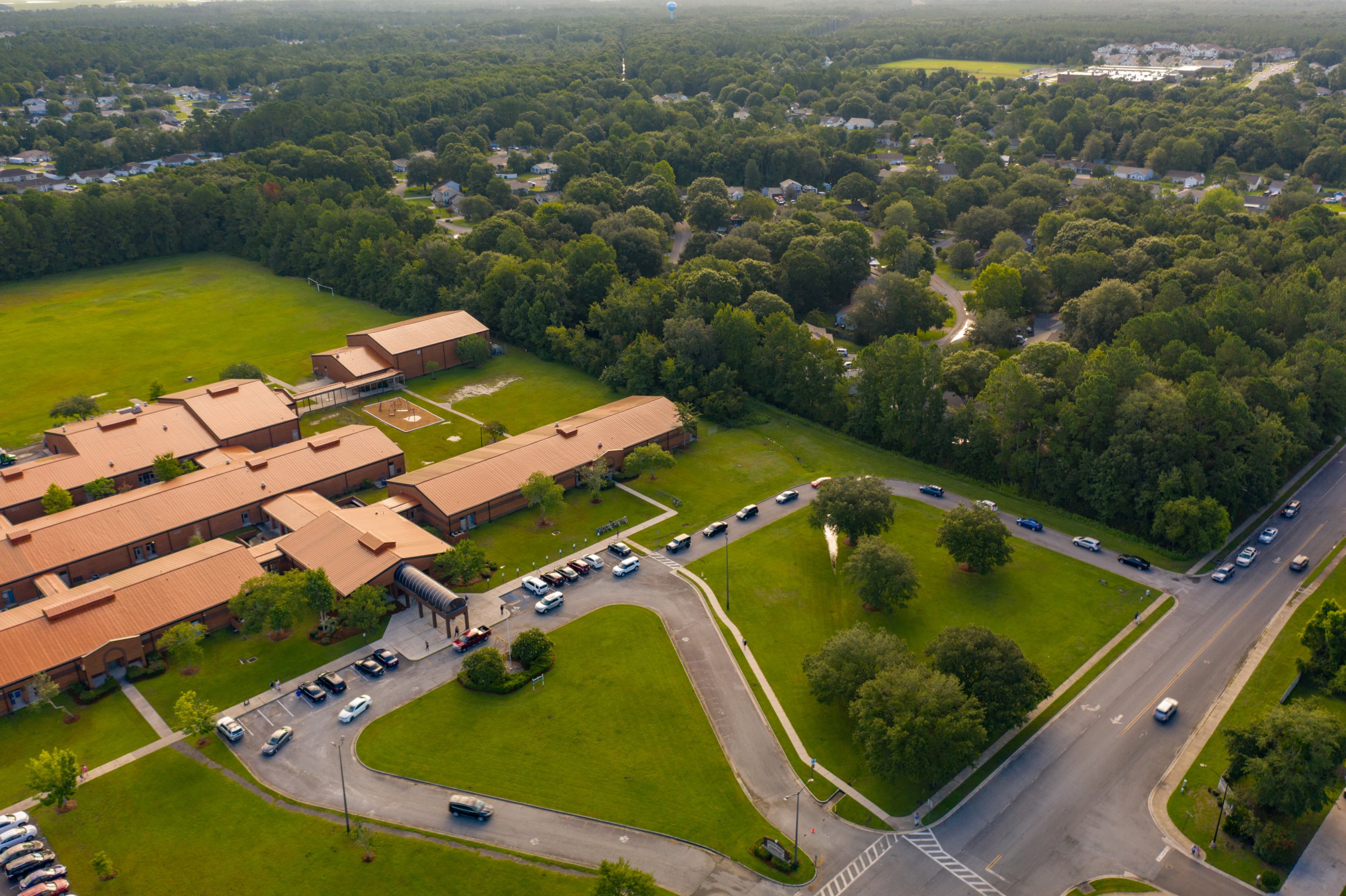
When we do an evaluation, we look at the roadway outside of and on campus property. That includes how vehicles enter and exit, where queues form and cars stack up, how bus traffic is separated from parent drop-off traffic, and how students move safely through the campus.
A Different Kind of Traffic Problem
After 26 years of planning and analyzing schools, one thing is clear. School traffic doesn’t behave like typical traffic patterns. It isn’t like a shopping center where vehicles arrive and depart continuously throughout the day and disperse into parking areas. School traffic is concentrated, directional, and time bound.
In a narrow time window, large volumes of vehicles and buses converge at the same access points to drop off or pick up students and then exit onto the roadway. Instead of dispersing, vehicles queue in sequence, often backing up through internal circulation and onto adjacent roadways. That creates a pattern that is unique to schools and unlike most other land uses. There is no gradual spread of traffic throughout the day, only defined morning and afternoon peaks tied to the school schedule.
Designing Movement Around Schools Today
What makes school traffic planning even more complicated today significantly depends on where a campus is located. Whether we are working with a rural or urban school determines how solutions are developed.
Many newer campuses are built where land is available and affordable, not necessarily close to the neighborhoods where students live. Even schools situated within neighborhoods experience more traffic today as more parents prefer to drive their kids to school. In fast-growing regions, entire school systems are being influenced by development and ongoing redistricting, which means students are coming from farther away and traveling in more directions than before.
Schools that once served nearby neighborhoods now function as regional facilities. This contributes to more cars, longer car lines, and greater pressure on campus layouts and surrounding public roads.
Rural vs. Urban Challenges
In rural settings, there can be more space to allow for longer on-site queueing and extended stacking lanes that keep vehicles contained within school property. In some cases, there is enough land to stack cars a half-mile or more on site. While these layouts require more land, they reduce interaction with surrounding roadways and give engineers more flexibility to manage circulation on site.
Urban schools situated in large cities and downtown areas operate under different conditions. There is limited space in these areas, which means there is little room for on-site queueing. Parents do not have as much room to stack, park, and wait, and moving vehicles through the system without blocking surrounding streets becomes the biggest challenge. These sites also require coordination with bus operations, pedestrian routes, and bicycle access within tight time windows.
We have performed traffic impact analyses and transportation management plans for urban schools in North Carolina (where I’m based out of), including schools in downtown Raleigh and in Greensboro. In both cases, the main issue was managing parent pickup in a way that did not interfere with surrounding streets.
Traffic strategies in these environments include implementing structured pickup times, staggered dismissal schedules, and use of nearby public or private properties for staging student drop offs and pickups when available. In some cases, students can be walked off campus in a coordinated way, or older students may have access to public transportation options. There are a range of strategies available, and each site requires a different approach based on its constraints.
Traffic management strategies in these settings focus on how a site operates rather than physical expansion. This often requires coordination between campus operations and surrounding land use to control peak demand and prevent queues from spilling into public streets. The approach has to remain flexible and responsive to the limitations of each site.
In fast-growing regions of the country such as Wake County, North Carolina, continued growth and redistricting add further complexity. The Wake County Public School System serves more than 161,000 students and is one of the largest school districts in the area.
Each campus requires a tailored approach based on its conditions. Our experience with diverse school environments allows us to develop practical, site-specific solutions that address challenges where standard approaches fall short. Many of these conditions require creative thinking and engineering judgment built through years of field experience. Ready to improve your school’s traffic flow? Contact our team today.

Rynal Stephenson, PE, serves as Chief Traffic Analysis Engineer for DRMP’s Transportation Market Sector.
Posted in the categories All, Traffic Impact Analysis.
Related Articles
 Jul23DRMP Gives Families a Lift Through Its Charity Bike BuildDRMP employees took time out of their da...See Details
 Jul21Wekiva Parkway Section 8 Interchange Closes Gap, Improves Regional Travel The Wekiva Parkway Section 8 Interchange...See Details
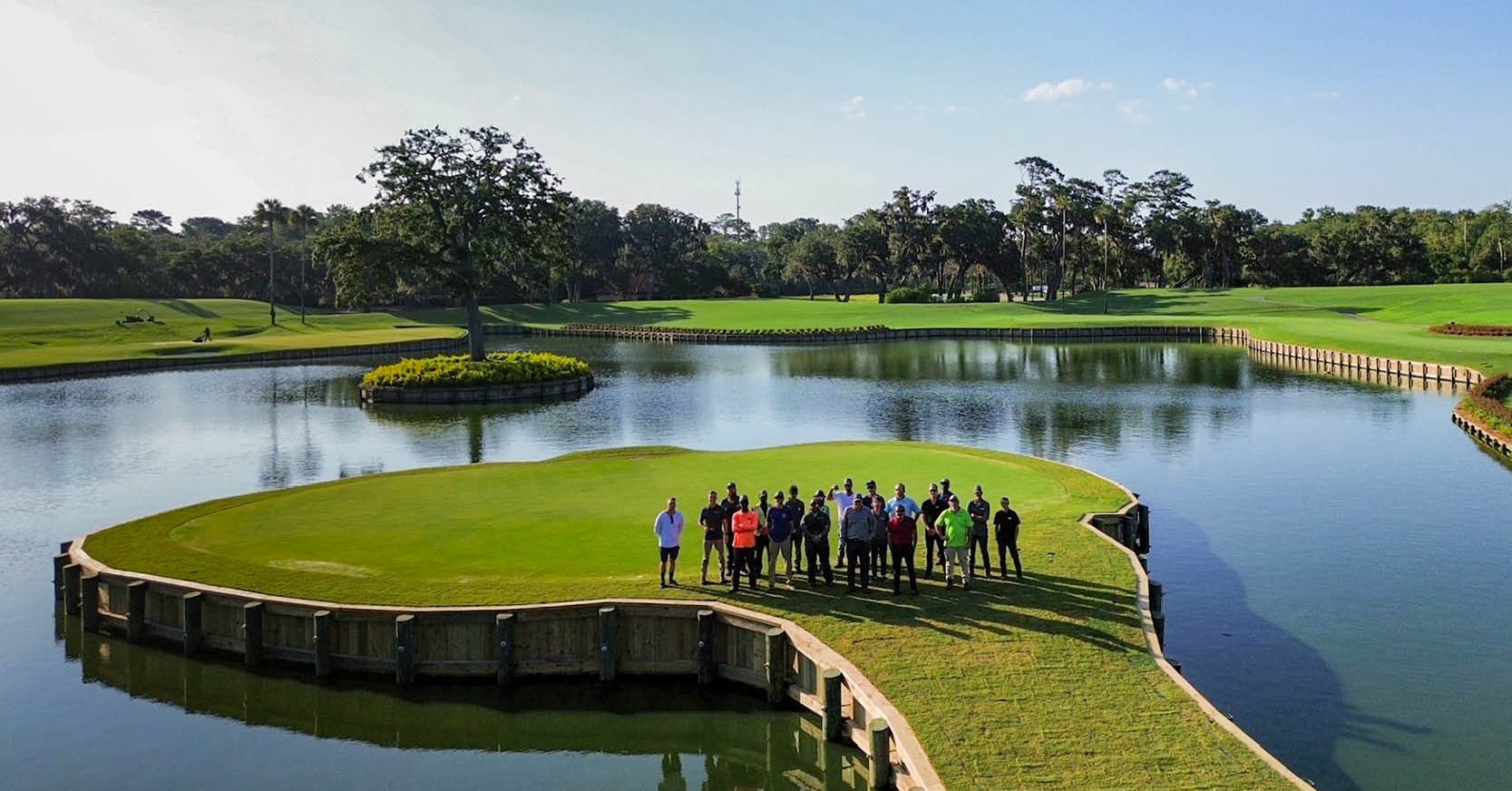 Jul14Surveying One of Golf’s Most Legendary Holes DRMP provided survey services for the re...See Details
 Jul7Port St. Lucie Intersection Upgrade Improves Safety at Village and Tradition ParkwaysDRMP delivered a comprehensive redesign ...See Details

Categories
- All
- Alternative Delivery
- Civil Services
- Construction Services
- Disaster Resilience and Sustainability
- DRMPCares
- Ecological Services
- Electrical Engineering
- eWIRE
- Federal Services
- Geographic Information Systems
- Hurricane
- Land Development
- Learning & Development
- NEPA
- Project Development & Environment
- Structural Engineering
- Subsurface Utility Engineering
- Surveying & Mapping
- Traffic Impact Analysis
- Transportation
- Transportation Planning/Project Development
- Utilities Engineering
- Water Resources/Stormwater Management
Contributors
- Michael K. Albano, PE
- Bruno J. Arriola, PE, ENV SP
- Alia Awwad, PE
- Brent Bass, PE, PSM
- Cody Bayer, PE
- Maria Bazemore, PWS, AICP
- Paul Benvie, PE
- Donald W. Brown, PE
- Kyle Brown, PE
- Jake Burton
- Zach J. Carnahan, PE
- David Couch
- Brian Crowl, PE
- Patrick Day, PE
- Nick DeVito, PE
- Joe Di Benedetto, PLS, LS
- Scott Garth, PE, LEED AP ND
- Ryan M. Grab, CST II
- Robyn Hartz, INCE
- Justin Hayes, EI
- Lucas S. Helms, PE
- Jim Highland, PE
- Ryan Ianacone, CST II
- Erica Jernigan, PE
- Ravneet Kathuria
- TJ Lallathin, Jr., PE, DBIA
- Jay McInnis, PE, CPM
- George McLatchey, PWS, CEP
- Ryan Mitchell, PE
- Megan E. Mott, PE
- Josh Norman
- Melissa Padilla Cintron, SIT
- Pavan Paiavula, PE
- Ryan Pellarin, PE, CCM
- AJ Perkinson, PLS
- Julian Poole, PE
- Kayla Poulos, PE
- Kim Sadowski, PE, RSP1
- John Schick, PTP
- Rachel L. Schmidt, PWS
- Logan Shappell
- Rynal Stephenson, PE
- Albert Taylor
- Deston Taylor, PE, PTOE
- Keelyn Taylor, PhD
- August Thick II, PLS
- Thomas Tracz, PSM
- Hung Tu, PE, SE
- Grady Vaughan, PE, PTOE, PTP
- Orville Williams
- Amanda E. Woods, PE


