- Discover
-
Expertise
-
Alternative Delivery
- I-275 at I-4 Downtown Tampa Interchange Design-Build
- Wekiva Parkway Section 8 Interchange
- US 17/92 Interchange at SR 436
- SR 9B Extension from I-95 to US 1
- A. Max Brewer Bridge Replacement
- I-95 Widening from the Indian River/Brevard County Line to Malabar Road
- SR 528 (Beachline Expressway) at Innovation Way Interchange
- SR 570 Polk Parkway Widening from I-4 to Pace Road
- I-95 Express Lanes and Ramp Signals – Phase 3A-1
- Pollard Road Extension over Peace Creek
- I-485 Widening from I-77 to Rea Road
- Monroe Bypass/Connector Design-Build
- Construction Services
- Ecological Services
-
Federal Services
- Range of the Future Study
- US Coast Guard Air Station (Clearwater)
- Ascension Island Fire Station Renovation
- Patrick Space Force Base Water Lines Repair
- Patrick Space Force Base Living Shoreline Restoration
- P-505 Electrical Hardening and Black Start CHP at Marine Corps Air Station Beaufort
- Naval Station at Guantanamo Bay Survey Services
- Repair Phillips Parkway and Speed Limit Study
- Ascension Island Auxiliary Airfield Surveying and Mapping Services
-
Geographic Information Systems (GIS)
- Thermal Design/Comprehensive Campus LiDAR Collection
- Greater Orlando Aviation Authority (GOAA) Strategic Commerical Land Development Program
- University of Florida Sanitary Sewer GIS Mapping
- Ascension Island Auxiliary Airfield GIS Integration
- Santa Rosa County School District's School Transportation & Capacity GIS Analysis
- Gainesville Community Redevelopment Agency Socioeconomic Analysis and Site Suitability Report
- Real Estate Site Suitability and Development Analysis
- SR 836 (Dolphin Expressway) GIS Asset Inventory of Pre-Post Construction
- Alachua County Public Schools GIS and School Planning Professional Services
- Patrick Space Force Base Living Shoreline Restoration GIS Analysis
- Florida Army National Guard Readiness Center GIS Inventory & Integration
- Comprehensive Transit Study Puerto Rico GIS Analysis
- Land Development
- Structural Engineering
-
Subsurface Utility Engineering (SUE)
- Thermal Design/Comprehensive Campus LiDAR Collection
- P-505 Electrical Hardening and Black Start CHP at Marine Corps Air Station Beaufort
- Resurface & Safety Improvements Turnpike Mainline
- University of Florida Rabon Utility Mapping
- FP&L Subsurface Utility Engineering Continuing On-Call Contract
- Lockheed Martin Subsurface Utility Engineering Services
- Palm Coast Parkway Subsurface Utility Engineering Services
- Surveying & Mapping/Geospatial
-
Traffic Impact Analysis
- 505 West Chapel Hill Street
- 5th Street Station
- Beale Farm Industrial Park
- Blue Mountain Mist Resort
- The Villages at McCullers Walk
- Fredericksburg National Baseball Stadium
- Hendrick Southpoint Auto Mall
- Apex Friendship Elementary School
- Whole Foods Center
- Barclay West
- Grove 98
- Pullen Drive Extension/Catholic Diocese
- Trails/Parks & Recreation Facilities
- Transportation
-
Utilities Engineering
- Ascension Island Fire Station Renovation
- M-1 Canal Water Main Extension
- 5th Street Bridge Utility Replacement
- Captain’s Cove Wastewater Plant Revisions & Permit Renewal
- City of Fort Myers Downtown Utility & Streetscape Improvement
- Florida Caverns State Park Lift Station Rehab
- Tween Waters Inn Wastewater Plant Permit Renewal
- City of Fort Myers Wastewater Capacity Studies
- Patrick Space Force Base Water Lines Repair
- Big Lagoon Boat Ramp Wastewater System
- St. Joseph State Park Septic Tank Replacement
- WildBlue Development Wastewater Modeling
- A-1 Gator Wastewater Capacity Increase
- Water Resources/Stormwater Management
-
Alternative Delivery
- Careers
- Insights
- Connect
- Powered By Trilon
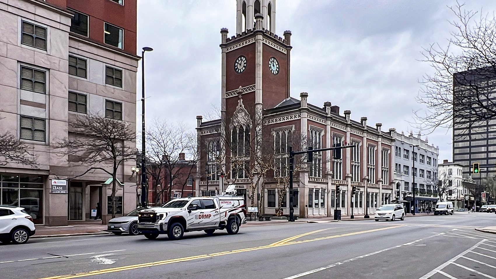
DRMP and Fuss & O’Neill Collaborate on Mobile LiDAR for New Hampshire Turnpike
June 2nd, 2026


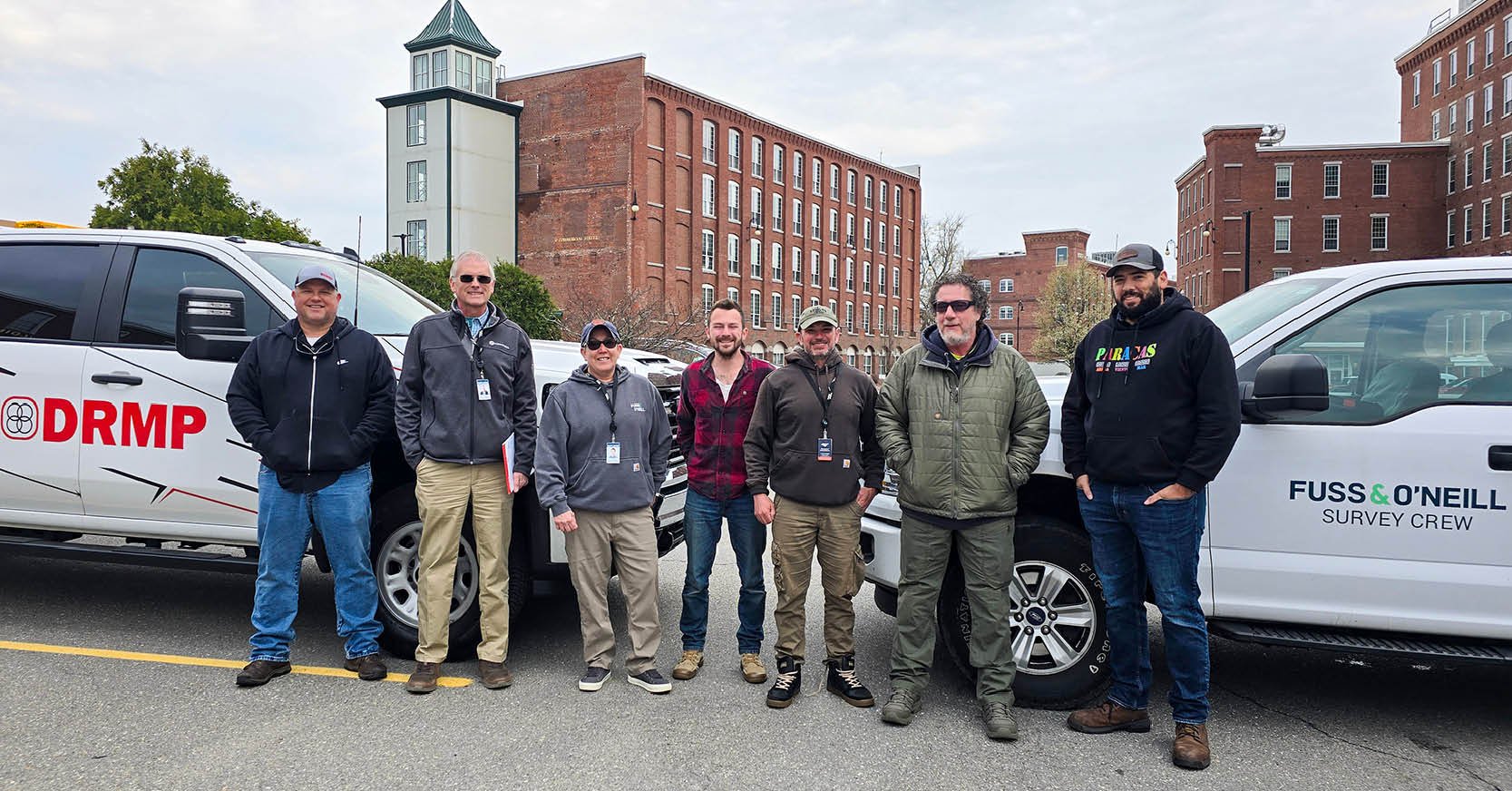
When fellow Trilon partner firm Fuss & O’Neill needed mobile LiDAR expertise for one of the largest survey projects in its New Hampshire office’s history, the firm turned to DRMP.
Supporting the New Hampshire Department of Transportation’s (NHDOT) widening of the F.E. Everett Turnpike (I-293) and exits 6 and 7 Interchange Reconstruction project (Manchester 16099), DRMP partnered with Fuss & O’Neill to deliver advanced mobile LiDAR scanning services along a 3.5-mile stretch of the turnpike in Manchester.
The project includes major improvements around exits 6 and 7 where roadway widening and interchange upgrades are planned through a constrained urban corridor bordered by the Merrimack River and Manchester’s historic Amoskeag Mill District. Once one of the world’s largest textile manufacturing centers, the district is now home to offices, technology space, and mixed-use development.
For DRMP, the project presented an opportunity to showcase the firm’s mobile LiDAR capabilities in the Northeast while helping a sister company safely and efficiently deliver complex survey data for a high-profile transportation project.
Mobile LiDAR Advantage
Fuss & O’Neill serves as the prime consultant for the survey portion of the project to provide conventional survey services throughout the corridor, while DRMP is leading the project’s mobile LiDAR data collection efforts as a subconsultant.
Traditional survey methods on an active, busy interstate often require extensive lane closures and expose field crews to potential traffic hazards. By incorporating mobile LiDAR technology, DRMP helped reduce those risks while significantly accelerating field operations.
“The collaboration went extremely smooth – smoother than I would have ever expected,” said Greg Brown, LLS, PLS, senior project manager at Fuss & O’Neill. “Everything moved quicker than I had anticipated, and our team got to see firsthand how DRMP’s mobile LiDAR process works in the field.”
DRMP’s mobile LiDAR experts captured detailed roadway and hard-surface conditions throughout the corridor, while Fuss & O’Neill is performing conventional survey efforts for soft surfaces, such as grassy areas, right-of-way boundaries, and supplemental topographic data.
Together, the firms are creating a complete existing conditions model that will support the interim improvement project and future phases of corridor design. The interim project includes improvements along approximately 1.25 miles near exit 6 where NHDOT plans to widen portions of the roadway and add a merge lane to help alleviate congestion near the Amoskeag Circle. Although the immediate design effort is limited to the interim improvements, DRMP completed mobile LiDAR scanning for the entire 3.5-mile corridor, including city streets connecting to the interchanges, so NHDOT will have existing conditions data available for future phases of the F.E. Everett Turnpike widening project.
Coordinating Across States and Teams
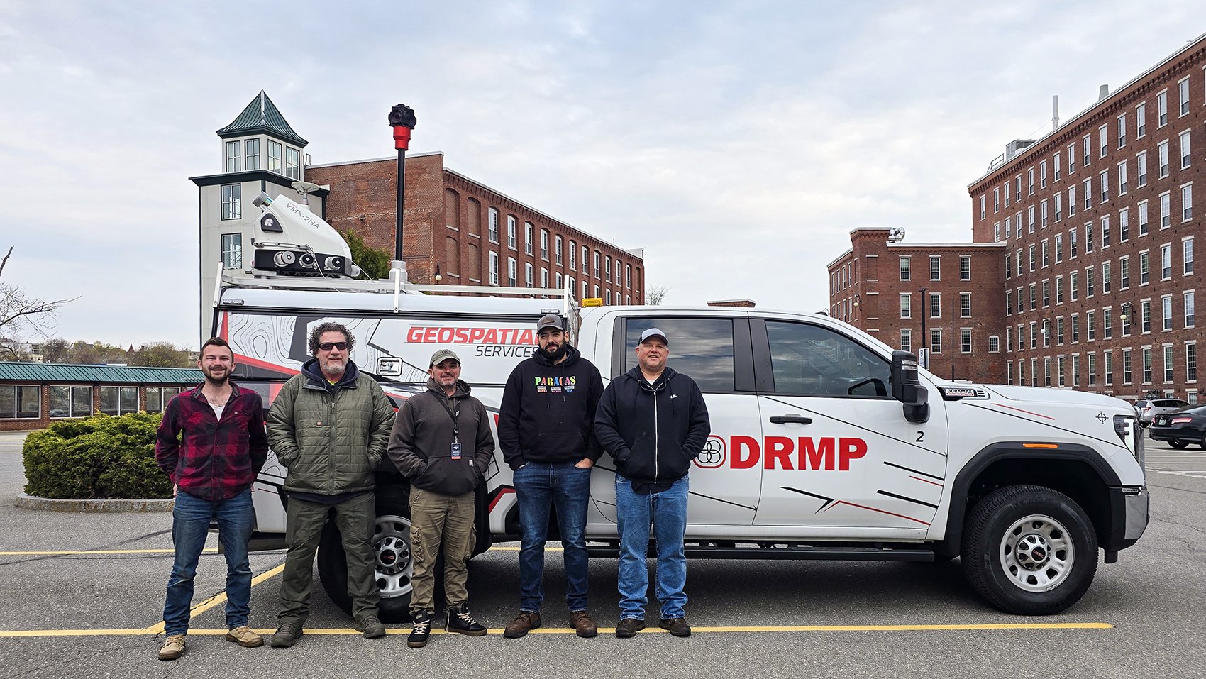
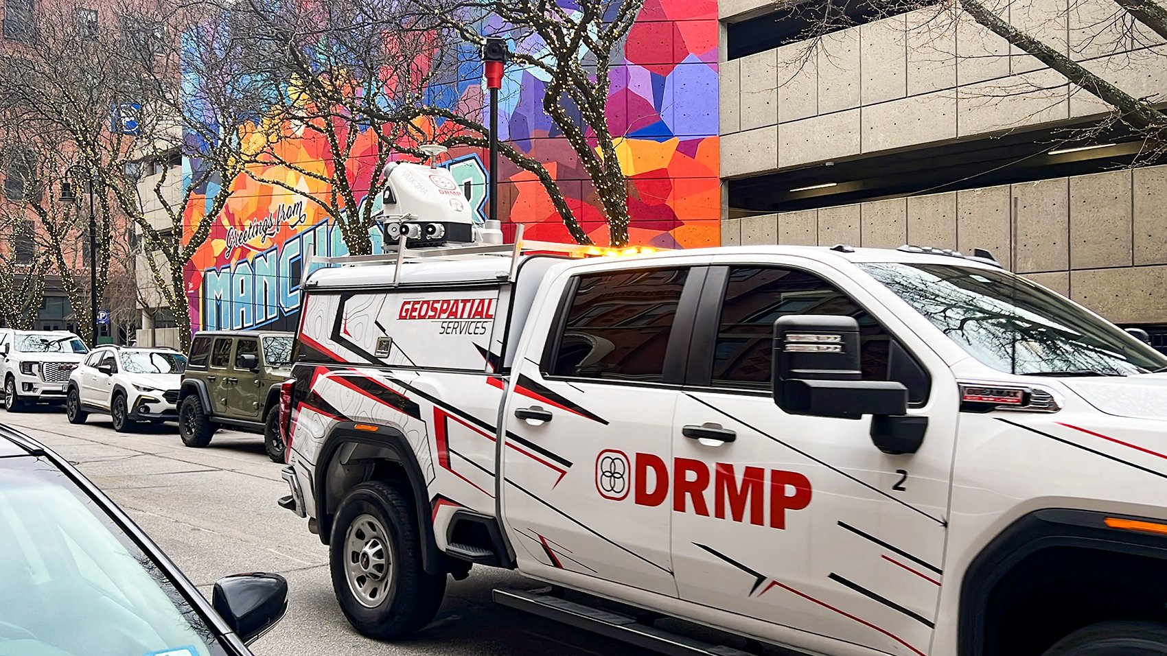
DRMP crews drove up from North Carolina and worked with Fuss & O’Neill’s survey team to establish reference targets throughout the corridor for the mobile LiDAR scanning process, painting markings approximately every 500 feet. DRMP also provided a field template and demonstrated the target-painting process so Fuss & O’Neill’s crews could replicate the methodology on future projects. New Hampshire does not currently have established standards for mobile LiDAR target spacing or control requirements. Standards vary by state, with some requiring more control targets than others. DRMP Vice President and Geospatial Services Division Manager Brent Bass, PE, PSM, elected to use the more restrictive standards of 500 feet, as required by the Florida Department of Transportation (FDOT) and the North Carolina Department of Transportation (NCDOT), to ensure the highest level of accuracy and consistency in the dataset.
DRMP’s scanning survey team flew from Florida to North Carolina to pick up its second mobile LiDAR scanning vehicle stationed in the Carolinas before making the approximately 14-hour drive to New Hampshire to support the project. Once on site, the team met with Fuss & O’Neill staff for a hands-on “show and tell” of the equipment and workflow so both teams could align on the field process and expectations before work began.
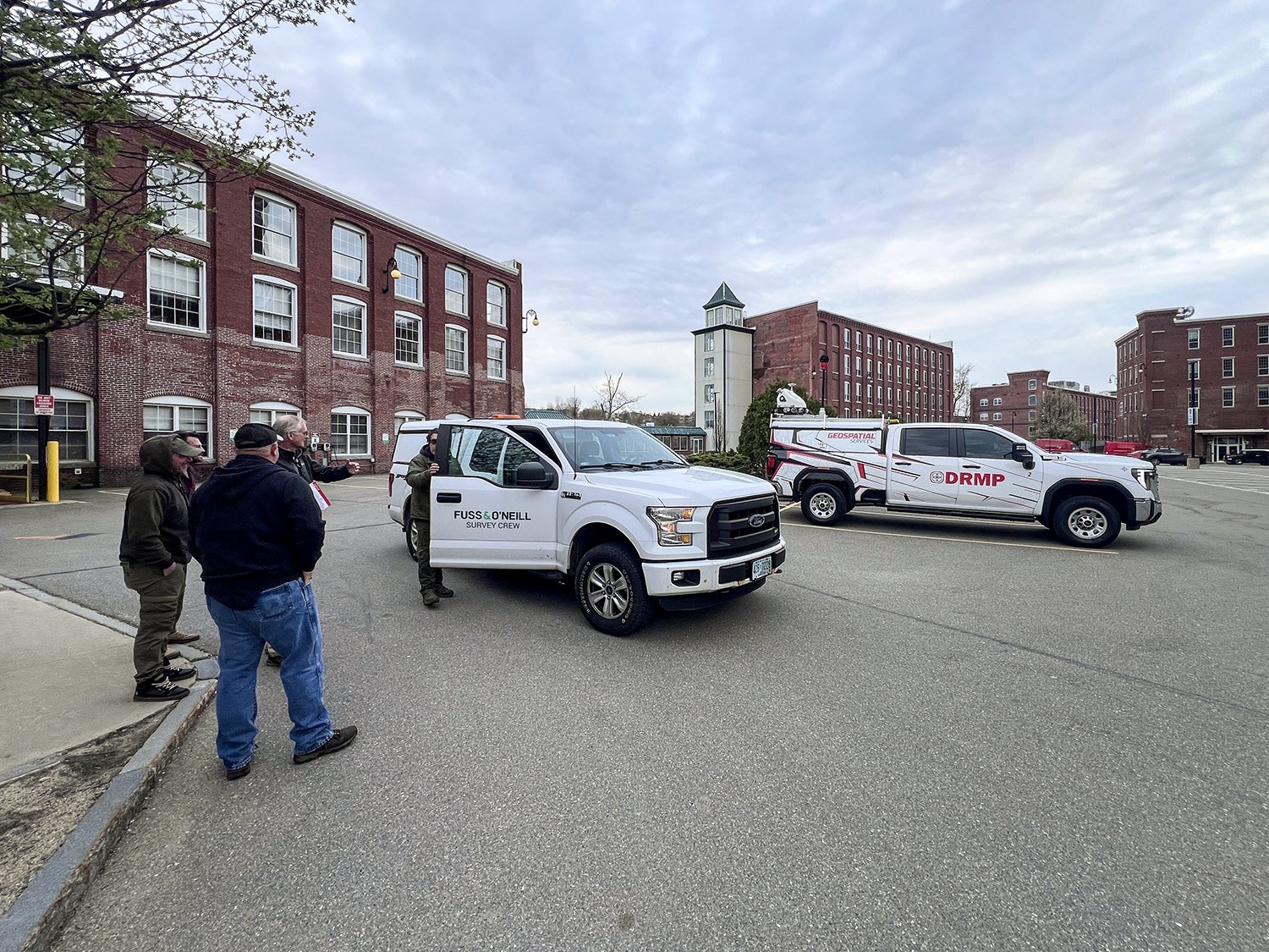
Fuss & O’Neill’s survey crews collected precise ground coordinates at these control and validation points. Those reference points allow for the scanned data to be properly positioned so it matched exact locations along the project corridor.
Demonstrating the Value of Mobile LiDAR
While mobile LiDAR has become increasingly common on transportation projects nationwide, the technology was still relatively new to some project stakeholders in New Hampshire.
Initially, DRMP was only tasked with scanning the interim improvement area, approximately 1.25 miles. After seeing the benefits of the technology, however, NHDOT expanded the scope and requested scanning for the entire 3.5-mile corridor so the data would already be available for future design phases.
Following data collection, DRMP will begin processing the point cloud data and performing feature extraction to develop a comprehensive 3D model of the corridor.
“This project went very smooth,” Bass said. “It required a lot of logistics planning. It couldn't have gone any better. The Fuss & O'Neill team has been just absolutely wonderful to work with.”
This project is a prime example of the value of collaboration across the Trilon platform, combining DRMP’s mobile LiDAR expertise with Fuss & O’Neill’s local survey knowledge and established client relationships. The combined effort will deliver a coordinated, data-rich solution supporting NHDOT’s turnpike improvements with advanced technology and expertise.
Posted in the categories All, Surveying & Mapping.
Related Articles
 Jul21Wekiva Parkway Section 8 Interchange Closes Gap, Improves Regional Travel The Wekiva Parkway Section 8 Interchange...See Details
 Jul14Surveying One of Golf’s Most Legendary Holes DRMP provided survey services for the re...See Details
 Jul7Port St. Lucie Intersection Upgrade Improves Safety at Village and Tradition ParkwaysDRMP delivered a comprehensive redesign ...See Details
 Jun25What Does Safety Look Like at DRMP Through a Safety Leader’s Eyes?Creating a safe workplace requires atten...See Details

Categories
- All
- Alternative Delivery
- Civil Services
- Construction Services
- Disaster Resilience and Sustainability
- DRMPCares
- Ecological Services
- Electrical Engineering
- eWIRE
- Federal Services
- Geographic Information Systems
- Hurricane
- Land Development
- Learning & Development
- NEPA
- Project Development & Environment
- Structural Engineering
- Subsurface Utility Engineering
- Surveying & Mapping
- Traffic Impact Analysis
- Transportation
- Transportation Planning/Project Development
- Utilities Engineering
- Water Resources/Stormwater Management
Contributors
- Michael K. Albano, PE
- Bruno J. Arriola, PE, ENV SP
- Alia Awwad, PE
- Brent Bass, PE, PSM
- Cody Bayer, PE
- Maria Bazemore, PWS, AICP
- Paul Benvie, PE
- Donald W. Brown, PE
- Kyle Brown, PE
- Jake Burton
- Zach J. Carnahan, PE
- David Couch
- Brian Crowl, PE
- Patrick Day, PE
- Nick DeVito, PE
- Joe Di Benedetto, PLS, LS
- Scott Garth, PE, LEED AP ND
- Ryan M. Grab, CST II
- Robyn Hartz, INCE
- Justin Hayes, EI
- Lucas S. Helms, PE
- Jim Highland, PE
- Ryan Ianacone, CST II
- Erica Jernigan, PE
- Ravneet Kathuria
- TJ Lallathin, Jr., PE, DBIA
- Jay McInnis, PE, CPM
- George McLatchey, PWS, CEP
- Ryan Mitchell, PE
- Megan E. Mott, PE
- Josh Norman
- Melissa Padilla Cintron, SIT
- Pavan Paiavula, PE
- Ryan Pellarin, PE, CCM
- AJ Perkinson, PLS
- Julian Poole, PE
- Kayla Poulos, PE
- Kim Sadowski, PE, RSP1
- John Schick, PTP
- Rachel L. Schmidt, PWS
- Logan Shappell
- Rynal Stephenson, PE
- Albert Taylor
- Deston Taylor, PE, PTOE
- Keelyn Taylor, PhD
- August Thick II, PLS
- Thomas Tracz, PSM
- Hung Tu, PE, SE
- Grady Vaughan, PE, PTOE, PTP
- Orville Williams
- Amanda E. Woods, PE


