- Discover
-
Expertise
-
Alternative Delivery
- I-275 at I-4 Downtown Tampa Interchange Design-Build
- Wekiva Parkway Section 8 Interchange
- US 17/92 Interchange at SR 436
- SR 9B Extension from I-95 to US 1
- A. Max Brewer Bridge Replacement
- I-95 Widening from the Indian River/Brevard County Line to Malabar Road
- SR 528 (Beachline Expressway) at Innovation Way Interchange
- SR 570 Polk Parkway Widening from I-4 to Pace Road
- I-95 Express Lanes and Ramp Signals – Phase 3A-1
- Pollard Road Extension over Peace Creek
- I-485 Widening from I-77 to Rea Road
- Monroe Bypass/Connector Design-Build
- Construction Services
- Ecological Services
-
Federal Services
- Range of the Future Study
- US Coast Guard Air Station (Clearwater)
- Ascension Island Fire Station Renovation
- Patrick Space Force Base Water Lines Repair
- Patrick Space Force Base Living Shoreline Restoration
- P-505 Electrical Hardening and Black Start CHP at Marine Corps Air Station Beaufort
- Naval Station at Guantanamo Bay Survey Services
- Repair Phillips Parkway and Speed Limit Study
- Ascension Island Auxiliary Airfield Surveying and Mapping Services
-
Geographic Information Systems (GIS)
- Thermal Design/Comprehensive Campus LiDAR Collection
- Greater Orlando Aviation Authority (GOAA) Strategic Commerical Land Development Program
- University of Florida Sanitary Sewer GIS Mapping
- Ascension Island Auxiliary Airfield GIS Integration
- Santa Rosa County School District's School Transportation & Capacity GIS Analysis
- Gainesville Community Redevelopment Agency Socioeconomic Analysis and Site Suitability Report
- Real Estate Site Suitability and Development Analysis
- SR 836 (Dolphin Expressway) GIS Asset Inventory of Pre-Post Construction
- Alachua County Public Schools GIS and School Planning Professional Services
- Patrick Space Force Base Living Shoreline Restoration GIS Analysis
- Florida Army National Guard Readiness Center GIS Inventory & Integration
- Comprehensive Transit Study Puerto Rico GIS Analysis
- Land Development
- Structural Engineering
-
Subsurface Utility Engineering (SUE)
- Thermal Design/Comprehensive Campus LiDAR Collection
- P-505 Electrical Hardening and Black Start CHP at Marine Corps Air Station Beaufort
- Resurface & Safety Improvements Turnpike Mainline
- University of Florida Rabon Utility Mapping
- FP&L Subsurface Utility Engineering Continuing On-Call Contract
- Lockheed Martin Subsurface Utility Engineering Services
- Palm Coast Parkway Subsurface Utility Engineering Services
- Surveying & Mapping/Geospatial
-
Traffic Impact Analysis
- 505 West Chapel Hill Street
- 5th Street Station
- Beale Farm Industrial Park
- Blue Mountain Mist Resort
- The Villages at McCullers Walk
- Fredericksburg National Baseball Stadium
- Hendrick Southpoint Auto Mall
- Apex Friendship Elementary School
- Whole Foods Center
- Barclay West
- Grove 98
- Pullen Drive Extension/Catholic Diocese
- Trails/Parks & Recreation Facilities
- Transportation
-
Utilities Engineering
- Ascension Island Fire Station Renovation
- M-1 Canal Water Main Extension
- 5th Street Bridge Utility Replacement
- Captain’s Cove Wastewater Plant Revisions & Permit Renewal
- City of Fort Myers Downtown Utility & Streetscape Improvement
- Florida Caverns State Park Lift Station Rehab
- Tween Waters Inn Wastewater Plant Permit Renewal
- City of Fort Myers Wastewater Capacity Studies
- Patrick Space Force Base Water Lines Repair
- Big Lagoon Boat Ramp Wastewater System
- St. Joseph State Park Septic Tank Replacement
- WildBlue Development Wastewater Modeling
- A-1 Gator Wastewater Capacity Increase
- Water Resources/Stormwater Management
-
Alternative Delivery
- Careers
- News
- #DRMPerspective
- Team With Us
- Locations


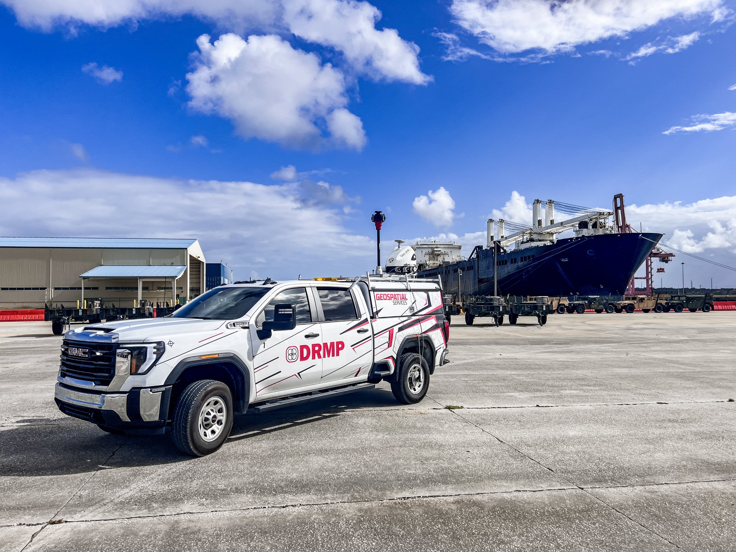
DRMP Experts to Showcase Mobile LiDAR’s Role in Advancing Military Engineering at SAME JETS 2025
October 15th, 2025


JACKSONVILLE, Fla. – Mobile LiDAR is transforming how data informs military engineering and infrastructure design. This technology delivers survey-grade accuracy while allowing work to continue safely around active installations, reducing disruptions and improving project efficiency. For military and federal clients, that means faster access to reliable data that supports smarter, safer engineering decisions.
DRMP will highlight the benefits of using this technology at the 2025 Society of American Military Engineers (SAME) Tri-Regional Joint Engineer Training Symposium (JETS), hosted by the Jacksonville Post, Oct. 21-23 at the Hyatt Regency Jacksonville Riverfront.
Federal Survey Manager Randy Tompkins, PSM, PLS, PS, and Mobile LiDAR Group Leader Bryant King, CST 1, will present “Precision in Motion: Advancing Military Engineering Design with Mobile LiDAR.” Their session will explore how DRMP helps agencies integrate LiDAR data into design and asset management systems to create accurate digital twins that improve decision-making and long-term facility management.
“Mobile LiDAR is becoming a standard tool for large engineering and surveying firms, but adoption within federal agencies is still emerging,” Tompkins said. “As agencies recognize the long-term value of high-accuracy geospatial data for asset management, planning, and resilience, LiDAR has evolved from an ‘innovative’ technology to an essential part of modern infrastructure and defense projects.”
Tompkins and King will share examples of Department of Defense (DoD) projects and case studies that demonstrate Mobile LiDAR’s effectiveness in architecture, engineering and construction, facility and infrastructure asset management, and resilience. They will discuss integration strategies, challenges, and the technology’s future potential.
“A few years ago, Mobile LiDAR was cutting-edge. Now it’s becoming standard practice. What’s changed is how seamlessly the data integrates into design and asset management systems. That’s where the real value is, turning accurate field data into actionable insight.
Advancements in LiDAR technology enable surveyors to capture detailed, three-dimensional (3D) data quickly and accurately across natural landscapes and built environments. On a recent DoD airfield project, DRMP mapped the entire airfield without interrupting flight operations. DRMP collected billions of data points (XYZ) in one day, creating a precise 3D model (Digital Twin) that informed site grading, infrastructure planning, and asset management. What would have taken weeks with traditional methods was completed safely in days without mission delays.
The session will also highlight how Mobile LiDAR supports real-time decision-making in emergencies and military scenarios. Following storm damage or during base expansion planning, DRMP’s experts can deploy vehicle-based LiDAR units to generate current terrain and infrastructure data within hours. This rapid turnaround allows engineers and commanders to make informed, data-driven decisions quickly and with confidence.
“Mobile LiDAR lets us collect the data we need without disrupting the mission,” Tompkins said. “We can work safely around active environments, capture more detail, and deliver information engineers and planners can trust.”
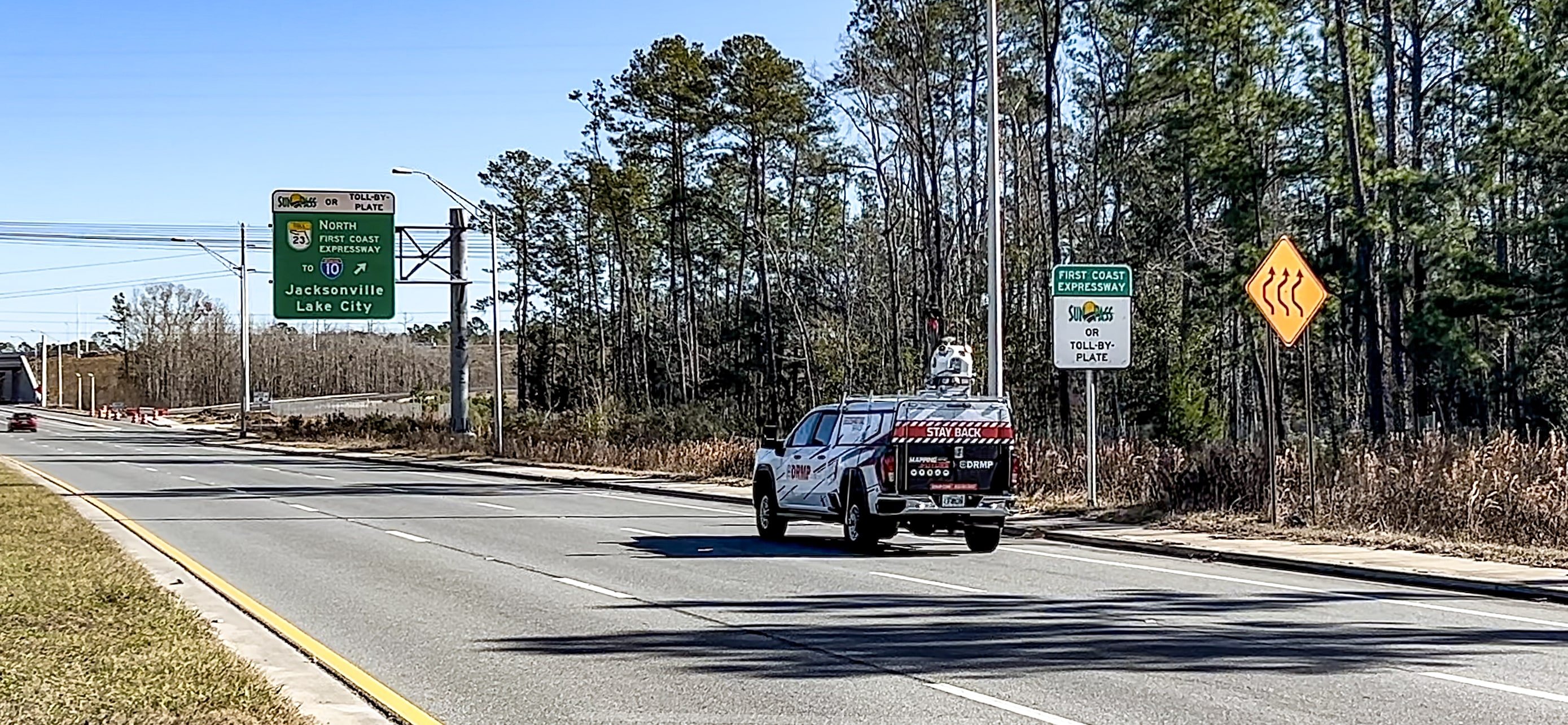
Mounted on vehicles or other mobile platforms, Mobile LiDAR systems collect large amounts of data at speeds often exceeding 60 mph. This reduces the time and costs associated with manual measurements and is especially valuable for roadway development, floodplain mapping, and environmental assessments. LiDAR’s ability to penetrate vegetation also makes it effective for forestry, urban planning, and archaeological studies.
Tompkins and King will also discuss how Mobile LiDAR complements unmanned aerial vehicle (UAV) LiDAR. Mobile LiDAR excels at collecting dense, high-accuracy data along corridors, flight lines, and developed areas, while UAV LiDAR is better for vertical structures, terrain modeling, and hard-to-reach spots. However, UAV operations on military installations can be difficult due to strict airspace regulations and security restrictions, making Mobile LiDAR a faster, more practical option for many federal projects.
“Every project shows how valuable it is to have complete, accurate data available when you need it,” King said. “That’s the capability Mobile LiDAR brings to our federal clients.”
About DRMP
DRMP is a multi-discipline firm serving clients in the public, private and industrial sectors in the development of infrastructure and has been in business since 1977. DRMP currently employs 700 professionals in 23 office locations spread strategically across our service area. Today, DRMP is ranked among Engineering News-Record’s “Top 500 Design Firms” in the United States. For more information, please visit www.drmp.com.
In Other News
 Oct14DRMP Strengthens Traffic Design Capabilities in Charlotte with New Project Manager
CHARLOTTE, N.C. – DRM...See Details
Oct14DRMP Strengthens Traffic Design Capabilities in Charlotte with New Project Manager
CHARLOTTE, N.C. – DRM...See Details Oct8DRMP’s Kim Sadowski Selected for 2026 Florida Engineering Leadership Institute
ORLANDO, Fla. – Congr...See Details
Oct8DRMP’s Kim Sadowski Selected for 2026 Florida Engineering Leadership Institute
ORLANDO, Fla. – Congr...See Details Oct8DRMP Promotes Samantha Bruce to New Safety Coordinator Role
ORLANDO, Fla. – DRMP ...See Details
Oct8DRMP Promotes Samantha Bruce to New Safety Coordinator Role
ORLANDO, Fla. – DRMP ...See Details Oct2 DRMP Charlotte Promotes Darren White, Supporting Team and Leadership Growth
CHARLOTTE, N.C. – As ...See Details
Oct2 DRMP Charlotte Promotes Darren White, Supporting Team and Leadership Growth
CHARLOTTE, N.C. – As ...See Details

Recent Articles
- 10/15/25Honoring the Life and Legacy of Tom Neyer, PE
- 10/15/25DRMP Experts to Showcase Mobile LiDAR’s Role in Advancing Military Engineering at SAME JETS 2025
- 10/14/25DRMP Strengthens Traffic Design Capabilities in Charlotte with New Project Manager
- 10/8/25DRMP’s Kim Sadowski Selected for 2026 Florida Engineering Leadership Institute
- 10/8/25DRMP Promotes Samantha Bruce to New Safety Coordinator Role
- 10/2/25 DRMP Charlotte Promotes Darren White, Supporting Team and Leadership Growth
- 09/26/25DRMP Honors Terry and Kim Durden’s Legacy in Florida Land Surveying Community
- 09/25/25DRMP Strengthens Geospatial Services Leadership with Promotions of Mark Brown and Bryant King
Archive
Events Calendar
DRMP eWIRE

Our bi-monthly digital newsletter offering the latest company news.


